Framed Print > North America > United States of America > New York > Related Images
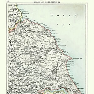
Framed Print : A chart of the East coast of Scotland from a sea-atlas containing an hydrographical


![]()
Framed Photos from Fine Art Finder
A chart of the East coast of Scotland from a sea-atlas containing an hydrographical
XOS1765726 A chart of the East coast of Scotland from a sea-atlas containing an hydrographical description of most of the sea-coasts of the known parts of the world by Samuel Thornton, 1707 (hand coloured print) by English School, (18th century); New York Public Library, USA; (add.info.: North is to right, top is West.); English, out of copyright
Media ID 12742645
© www.bridgemanimages.com
Atlas Firth Of Forth Hydrography Navigation Rhumb Lines River Tay Sea Chart Shipping St Andrews
12"x10" Modern Frame
Discover the rich maritime history of Scotland with our stunning Framed Prints from Media Storehouse. Featuring an intricately detailed chart of the East coast from a rare 18th-century sea-atlas, this exquisite artwork by Samuel Thornton showcases the hydrographical description of most of the known parts of the world. The chart, sourced from Bridgeman Images through Fine Art Finder, adds an elegant and educational touch to any room, transporting you back in time to the age of exploration. With our high-quality framing options, this unique piece is sure to make a captivating addition to your home or office decor.
10x8 Print in an MDF Wooden Frame with 180 gsm Satin Finish Paper. Glazed using shatter proof thin plexi glass. Frame thickness is 1 inch and depth 0.75 inch. Fluted cardboard backing held with clips. Supplied ready to hang with sawtooth hanger and rubber bumpers. Spot clean with a damp cloth. Packaged foam wrapped in a card.
Contemporary Framed and Mounted Prints - Professionally Made and Ready to Hang
Estimated Image Size (if not cropped) is 25.4cm x 25.4cm (10" x 10")
Estimated Product Size is 30.5cm x 25.4cm (12" x 10")
These are individually made so all sizes are approximate
Artwork printed orientated as per the preview above, with landscape (horizontal) or portrait (vertical) orientation to match the source image.
FEATURES IN THESE COLLECTIONS
> Fine Art Finder
> Maps (celestial & Terrestrial)
> Fine Art Finder
> Schools
> English School
> North America
> United States of America
> New York
> Related Images
EDITORS COMMENTS
This print showcases "A chart of the East coast of Scotland from a sea-atlas containing a hydrographical description of most of the sea-coasts of the known parts of the world" by Samuel Thornton, dating back to 1707. The hand-colored print, created by an English School artist in the 18th century, is housed at the New York Public Library in the USA. The intricately detailed map depicts various elements essential for navigation and cartography enthusiasts. With its focus on maritime routes and shipping lanes, this historical artifact offers a glimpse into Britain's rich seafaring history. Notably, it highlights key features such as Edinburgh Firth, Firth of Forth, River Tay, St Andrews, and pictorial relief. What makes this piece truly fascinating is that North is depicted to be on the right side while West occupies the top portion. This unconventional orientation adds an element of intrigue to an already visually stunning work. Accompanied by rhumb lines that aid in measuring distances and plotting courses accurately at sea, this hydrographical masterpiece serves as both a practical tool for sailors and a testament to human ingenuity in mapping uncharted territories. Thanks to Fine Art Finder's collaboration with Bridgeman Images. com. , we can now appreciate this remarkable artwork without any commercial restrictions. So take your time exploring every intricate detail within this mesmerizing depiction of Scotland's east coast - where land meets ocean in perfect harmony.
MADE IN THE USA
Safe Shipping with 30 Day Money Back Guarantee
FREE PERSONALISATION*
We are proud to offer a range of customisation features including Personalised Captions, Color Filters and Picture Zoom Tools
SECURE PAYMENTS
We happily accept a wide range of payment options so you can pay for the things you need in the way that is most convenient for you
* Options may vary by product and licensing agreement. Zoomed Pictures can be adjusted in the Cart.