Framed Print > Animals > Birds > Columbiformes > Doves > Black Dove
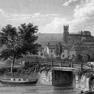
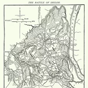
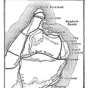
Framed Print : Map of the Cinque Ports (Victorian engraving)
")
")
![]()
Framed Photos from Fine Art Storehouse
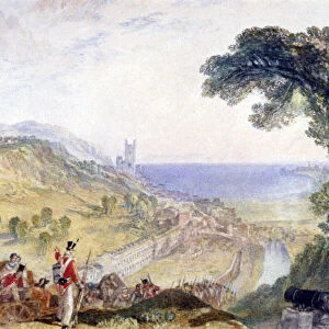
Map of the Cinque Ports (Victorian engraving)
An old map of the Cinque Ports, which are five historic ports on the south-eastern corner of Kent, England. The Confederation of Cinque Ports (Cinque is pronounced asinka) was originally formed for trade and military purposes but now exists as a mainly ceremonial organisation. The original Ports were Hastings, New Romney, Hythe, Dover and Sandwich, though when Romney silted up, Rye became one of the Ports. From Our Own Country: Descriptive, Historical, Pictoriala published by Cassell & Co Ltd, 1885
Unleash your creativity and transform your space into a visual masterpiece!
whitemay
Media ID 13667309
© This content is subject to copyright
Battle British Culture Direction Dover England East Sussex English Channel English Culture Harbor Hastings Kent England Line Art Monochrome Nostalgia Sandwich Social History Sussex Beachy Head Cinque Ports Dungeness Folkestone Hythe Pevensey Bay Romney Winchelsea
18"x14" Modern Frame
Discover the rich history of the Cinque Ports with our stunning Framed Print of "Map of the Cinque Ports (Victorian engraving)" from the Fine Art Storehouse by Whitemay. This exquisite piece showcases an intricately detailed Victorian engraving of the five historic ports on the south-eastern corner of Kent, England. The Confederation of Cinque Ports, also known as the Five Burroughs, has a long and fascinating history that dates back to the Middle Ages. Bring the charm of this maritime tradition into your home or office with our beautifully crafted framed print. Each print is carefully framed and ready to hang, making it an excellent addition to any decor. Experience the allure of the Cinque Ports with our Framed Print, a timeless piece that tells a captivating story.
16x12 Print in an MDF Wooden Frame with 180 gsm Satin Finish Paper. Glazed using shatter proof thin plexiglass. Frame thickness is 1 inch and depth 0.75 inch. Fluted cardboard backing held with clips. Supplied ready to hang with sawtooth hanger and rubber bumpers. Spot clean with a damp cloth. Packaged foam wrapped in a card.
Contemporary Framed and Mounted Prints - Professionally Made and Ready to Hang
Estimated Image Size (if not cropped) is 35.6cm x 40.6cm (14" x 16")
Estimated Product Size is 35.6cm x 45.7cm (14" x 18")
These are individually made so all sizes are approximate
Artwork printed orientated as per the preview above, with portrait (vertical) orientation to match the source image.
FEATURES IN THESE COLLECTIONS
> Fine Art Storehouse
> History
> Battles & Wars
> Historcal Battle Maps and Plans
> Fine Art Storehouse
> Map
> Historical Maps
> Animals
> Birds
> Columbiformes
> Doves
> Black Dove
> Animals
> Birds
> Columbiformes
> Doves
> Related Images
> Arts
> Minimalist artwork
> Monochrome artwork
> Black and white artwork
> Arts
> Minimalist artwork
> Monochrome artwork
> Fine art
> Arts
> Minimalist artwork
> Monochrome artwork
> Monochrome paintings
> Europe
> United Kingdom
> England
> East Sussex
> Battle
> Europe
> United Kingdom
> England
> East Sussex
> Hastings
> Europe
> United Kingdom
> England
> East Sussex
> Related Images
> Europe
> United Kingdom
> England
> East Sussex
> Rye
> Europe
> United Kingdom
> England
> East Sussex
> Winchelsea
EDITORS COMMENTS
This Victorian engraving showcases an old map of the Cinque Ports, a group of five historic ports nestled in the southeastern corner of Kent, England. Originally established for trade and military purposes, the Confederation of Cinque Ports has evolved into a primarily ceremonial organization. The original ports included Hastings, New Romney, Hythe, Dover, and Sandwich; however, when Romney silted up over time, Rye took its place among these renowned harbors. Published in 1885 by Cassell & Co Ltd as part of "Our Own Country: Descriptive Historical Pictorial" this vertical panoramic print offers a glimpse into the past with its black and white depiction. From Dungeness to Winchelsea and Pevensey Bay to Folkestone—each location is meticulously illustrated on this enchanting map. Transporting us back through time with its monochrome charm and intricate details, this engraved image invites us to explore British culture and social history from the 19th century. It captures not only the geographical features but also evokes nostalgia for a bygone era filled with battles fought along these shores. As we gaze upon this remarkable piece of cartography depicting ancient coastlines along the English Channel's edge, it serves as a reminder that history is etched within every line. A testament to England's rich maritime heritage and cultural significance, this print preserves our connection to centuries past while igniting our curiosity about these famous destinations within East Sussex.
MADE IN THE USA
Safe Shipping with 30 Day Money Back Guarantee
FREE PERSONALISATION*
We are proud to offer a range of customisation features including Personalised Captions, Color Filters and Picture Zoom Tools
SECURE PAYMENTS
We happily accept a wide range of payment options so you can pay for the things you need in the way that is most convenient for you
* Options may vary by product and licensing agreement. Zoomed Pictures can be adjusted in the Cart.