Framed Print > North America > United States of America > New York > New York > Maps
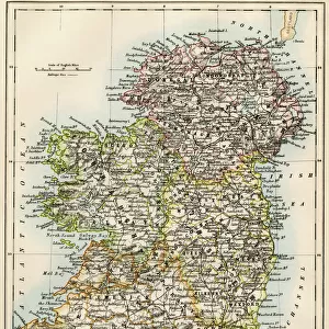
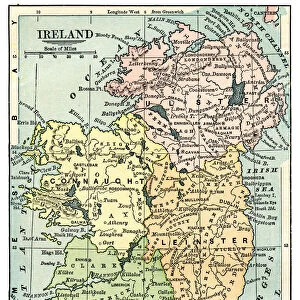
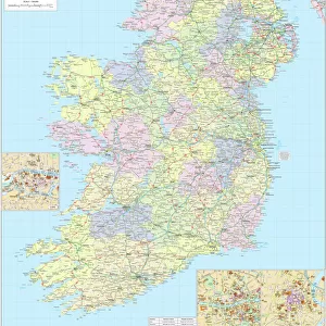
Framed Print : Ireland map 1875


![]()
Framed Photos from Fine Art Storehouse
Ireland map 1875
The Independent Course Comprehensive Geography by James Monteith, A.S. Barnes & Co, New York & Chicago 1875
Unleash your creativity and transform your space into a visual masterpiece!
THEPALMER
Media ID 13612193
© This content is subject to copyright
Globe Navigational Equipment Ireland Paper
12"x10" Modern Frame
Step back in time with our exquisite 'Ireland Map 1875' Framed Print from The Palmer Collection at Media Storehouse. This vintage map, originally published in James Monteith's 'The Independent Course in Geography' by A.S. Barnes & Co in 1875, showcases Ireland's historical cartography with intricate detail. The antique charm of this map is beautifully preserved in our high-quality frame, making it an exceptional addition to any home or office. Travel back in time and explore the rich history of Ireland with this captivating piece.
10x8 Print in an MDF Wooden Frame with 180 gsm Satin Finish Paper. Glazed using shatter proof thin plexi glass. Frame thickness is 1 inch and depth 0.75 inch. Fluted cardboard backing held with clips. Supplied ready to hang with sawtooth hanger and rubber bumpers. Spot clean with a damp cloth. Packaged foam wrapped in a card.
Contemporary Framed and Mounted Prints - Professionally Made and Ready to Hang
Estimated Image Size (if not cropped) is 25.4cm x 25.4cm (10" x 10")
Estimated Product Size is 25.4cm x 30.5cm (10" x 12")
These are individually made so all sizes are approximate
Artwork printed orientated as per the preview above, with landscape (horizontal) or portrait (vertical) orientation to match the source image.
FEATURES IN THESE COLLECTIONS
> Fine Art Storehouse
> The Magical World of Illustration
> Palmer Illustrated Collection
> Fine Art Storehouse
> Map
> Historical Maps
> Europe
> Republic of Ireland
> Maps
> Maps and Charts
> Related Images
> North America
> United States of America
> Maps
> North America
> United States of America
> New York
> New York
> Maps
> North America
> United States of America
> New York
> Related Images
EDITORS COMMENTS
This print takes us back in time to the year 1875, when James Monteith's "The Independent Course Comprehensive Geography" was published by A. S. Barnes & Co in New York and Chicago. The focus of this particular image is an intricately detailed map of Ireland, showcasing its geographical features with remarkable precision. Printed on aged paper, this antique engraving transports us to a world where cartography was both a science and an art form. The delicate lines etched into the illustration highlight the country's rivers, mountains, and coastlines, offering a glimpse into Ireland's physical geography as it existed over a century ago. As we examine this vertical composition closely, our eyes are drawn to navigational equipment scattered around the map - symbols of exploration and discovery that remind us of the importance placed on global connectivity during that era. This juxtaposition between old-world charm and modernity adds depth to the overall aesthetic appeal of the piece. "The Independent Course Comprehensive Geography" serves as more than just a historical artifact; it is also a testament to human curiosity and our innate desire for knowledge about distant lands. Through THEPALMER's lens, this print captures not only an exquisite work of cartographic art but also invites us to reflect upon how far we have come in understanding our planet since 1875.
MADE IN THE USA
Safe Shipping with 30 Day Money Back Guarantee
FREE PERSONALISATION*
We are proud to offer a range of customisation features including Personalised Captions, Color Filters and Picture Zoom Tools
SECURE PAYMENTS
We happily accept a wide range of payment options so you can pay for the things you need in the way that is most convenient for you
* Options may vary by product and licensing agreement. Zoomed Pictures can be adjusted in the Cart.