Framed Print > Fine Art Storehouse > Map
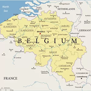
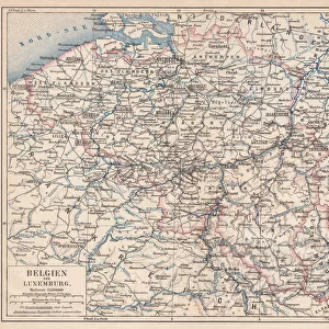
Framed Print : City map of Antwerp and surrounding, Belgium, lithograph, published 1897


![]()
Framed Photos from Fine Art Storehouse
City map of Antwerp and surrounding, Belgium, lithograph, published 1897
City map of Antwerp and surrounding, Belgium. Lithograph, published in 1897
Unleash your creativity and transform your space into a visual masterpiece!
Media ID 14646620
Antwerp Belgian Culture Belgium Benelux Canal City Map Colorful European Culture Flanders Haven Past Plan Port Surroundings Scheldt Scheldt River
18"x14" Modern Frame
Discover the rich history and charm of Antwerp, Belgium with our exquisite Framed Print featuring a stunning lithograph of the city map published in 1897. This beautiful piece of fine art showcases intricate details of Antwerp and its surrounding areas, transporting you back in time. The lithograph, published over a century ago, showcases the city's architectural wonders and historical landmarks with exceptional precision. Each print is carefully framed in a contemporary style, adding an elegant touch to any room in your home or office. Bring a piece of Belgian history into your space and create a unique conversation starter with our City Map of Antwerp Framed Print from Media Storehouse's Fine Art Collection.
16x12 Print in an MDF Wooden Frame with 180 gsm Satin Finish Paper. Glazed using shatter proof thin plexiglass. Frame thickness is 1 inch and depth 0.75 inch. Fluted cardboard backing held with clips. Supplied ready to hang with sawtooth hanger and rubber bumpers. Spot clean with a damp cloth. Packaged foam wrapped in a card.
Contemporary Framed and Mounted Prints - Professionally Made and Ready to Hang
Estimated Image Size (if not cropped) is 40.6cm x 35.6cm (16" x 14")
Estimated Product Size is 45.7cm x 35.6cm (18" x 14")
These are individually made so all sizes are approximate
Artwork printed orientated as per the preview above, with landscape (horizontal) orientation to match the source image.
FEATURES IN THESE COLLECTIONS
> Fine Art Storehouse
> Map
> Historical Maps
EDITORS COMMENTS
This vibrant lithograph print from 1897 showcases the intricate city map of Antwerp and its surrounding areas in Belgium. The detailed illustration captures the essence of this historic European city, known for its rich Belgian culture and captivating landscapes. The map highlights key features such as the meandering Scheldt River, which has played a significant role in shaping Antwerp's history and development. The bustling downtown district is depicted with colorful engravings, showcasing the architectural beauty that defines this charming town. As you explore this antique print, you can envision how Antwerp thrived as a prominent port city during the 19th century. Its strategic location along canals and its thriving harbor made it an essential hub for trade within Europe and beyond. This lithograph offers a glimpse into Antwerp's past, allowing us to appreciate both its historical significance and aesthetic charm. Whether you are an avid collector or simply fascinated by European culture, this stunning piece serves as a visual time capsule that transports you back to the late 19th century.
MADE IN THE USA
Safe Shipping with 30 Day Money Back Guarantee
FREE PERSONALISATION*
We are proud to offer a range of customisation features including Personalised Captions, Color Filters and Picture Zoom Tools
SECURE PAYMENTS
We happily accept a wide range of payment options so you can pay for the things you need in the way that is most convenient for you
* Options may vary by product and licensing agreement. Zoomed Pictures can be adjusted in the Cart.