Framed Print > Europe > Austria > Maps
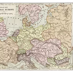
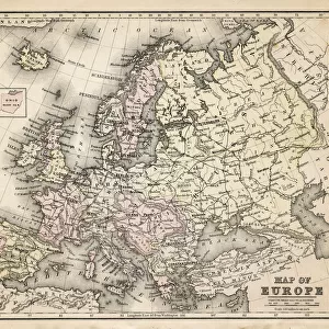
Framed Print : Map of Europe 1889


![]()
Framed Photos from Fine Art Storehouse
Map of Europe 1889
Indiana Educational Series The Complete Geography - Indianapolis 1889
Unleash your creativity and transform your space into a visual masterpiece!
THEPALMER
Media ID 14756326
© This content is subject to copyright
Austria Denmark Norway Portugal Russia Sweden
12"x10" Modern Frame
Step back in time with our exquisite Framed Print of "Map of Europe 1889" by THEPALMER from the Fine Art Storehouse Indiana Educational Series. This captivating vintage map, originally published in 1889, offers a fascinating glimpse into European geography from over a century ago. The intricate details and elegant design make this framed print an excellent addition to any home or office, transporting you to a bygone era. Bring history to life with this unique and captivating piece.
10x8 Print in an MDF Wooden Frame with 180 gsm Satin Finish Paper. Glazed using shatter proof thin plexi glass. Frame thickness is 1 inch and depth 0.75 inch. Fluted cardboard backing held with clips. Supplied ready to hang with sawtooth hanger and rubber bumpers. Spot clean with a damp cloth. Packaged foam wrapped in a card.
Contemporary Framed and Mounted Prints - Professionally Made and Ready to Hang
Estimated Image Size (if not cropped) is 25.4cm x 25.4cm (10" x 10")
Estimated Product Size is 30.5cm x 25.4cm (12" x 10")
These are individually made so all sizes are approximate
Artwork printed orientated as per the preview above, with landscape (horizontal) or portrait (vertical) orientation to match the source image.
FEATURES IN THESE COLLECTIONS
> Fine Art Storehouse
> Map
> Denmark Maps
> Fine Art Storehouse
> Map
> Historical Maps
> Fine Art Storehouse
> Map
> Italian Maps
> Europe
> Austria
> Related Images
> Europe
> Denmark
> Related Images
> Europe
> Germany
> Related Images
EDITORS COMMENTS
This print titled "Map of Europe 1889" takes us on a journey back in time to the late 19th century. A part of the Indiana Educational Series, this vintage map showcases the intricate details and artistic craftsmanship that were characteristic of cartography during that era. The map, originating from Indianapolis in 1889, provides a fascinating glimpse into how Europeans perceived their continent over a century ago. With its rich color palette and meticulous depiction of geographical boundaries, this print offers an immersive experience for history enthusiasts and geography lovers alike. From Portugal to Russia, it encompasses all major European countries such as Austria, Denmark, France, Germany, Italy, Norway, Spain, Sweden - each marked with precision and accuracy. The fine art quality of this photograph allows viewers to appreciate every minute detail on display. The aged texture adds depth and character to the image while preserving its historical significance. Whether displayed in a classroom or as an elegant addition to your home decor collection, "Map of Europe 1889" by THEPALMER is sure to spark conversations about our ever-evolving world. As we gaze upon this remarkable piece from Fine Art Storehouse's collection without considering commercial use but rather appreciating it purely for its aesthetic value - we are transported back in time; reminded of the vastness and diversity that has shaped our beloved continent throughout centuries past.
MADE IN THE USA
Safe Shipping with 30 Day Money Back Guarantee
FREE PERSONALISATION*
We are proud to offer a range of customisation features including Personalised Captions, Color Filters and Picture Zoom Tools
SECURE PAYMENTS
We happily accept a wide range of payment options so you can pay for the things you need in the way that is most convenient for you
* Options may vary by product and licensing agreement. Zoomed Pictures can be adjusted in the Cart.