Jigsaw Puzzle > Europe > Austria > Maps
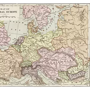
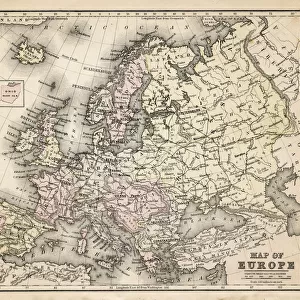
Jigsaw Puzzle : Map of Europe 1889


![]()
Jigsaw Puzzles from Fine Art Storehouse
Map of Europe 1889
Indiana Educational Series The Complete Geography - Indianapolis 1889
Unleash your creativity and transform your space into a visual masterpiece!
THEPALMER
Media ID 14756326
© This content is subject to copyright
Austria Denmark Norway Portugal Russia Sweden
Jigsaw Puzzle (520 Pieces)
Discover the historical wonders of Europe with our intricately designed jigsaw puzzle from Media Storehouse. Featuring the detailed and captivating "Map of Europe 1889" by THEPALMER from the Fine Art Storehouse, this puzzle is an educational treat for history and geography enthusiasts. Travel back in time to the Indianapolis 1889 edition of The Complete Geography series and piece together the complex yet rewarding puzzle. Immerse yourself in the rich history of Europe as you connect each piece to reveal the beautifully illustrated map. Perfect for individuals or families, this jigsaw puzzle is a fun and engaging way to learn and explore the historical geography of Europe. Engage your mind, challenge your problem-solving skills, and create a stunning display piece with the Media Storehouse Map of Europe 1889 puzzle.
Made in the USA, 520-piece puzzles measure 16" x 20" (40.6 x 50.8 cm). Every puzzle is meticulously printed on glossy photo paper, which has a strong 1.33 mm thickness. Delivered in a black storage cardboard box, these puzzles are both stylish and practical. (Note: puzzles contain small parts and are not suitable for children under 3 years of age.)
Jigsaw Puzzles are an ideal gift for any occasion
Estimated Product Size is 50.8cm x 40.5cm (20" x 15.9")
These are individually made so all sizes are approximate
Artwork printed orientated as per the preview above, with landscape (horizontal) or portrait (vertical) orientation to match the source image.
FEATURES IN THESE COLLECTIONS
> Fine Art Storehouse
> Map
> Denmark Maps
> Fine Art Storehouse
> Map
> Historical Maps
> Fine Art Storehouse
> Map
> Italian Maps
> Europe
> Austria
> Related Images
> Europe
> Denmark
> Related Images
> Europe
> Germany
> Related Images
EDITORS COMMENTS
This print titled "Map of Europe 1889" takes us on a journey back in time to the late 19th century. A part of the Indiana Educational Series, this vintage map showcases the intricate details and artistic craftsmanship that were characteristic of cartography during that era. The map, originating from Indianapolis in 1889, provides a fascinating glimpse into how Europeans perceived their continent over a century ago. With its rich color palette and meticulous depiction of geographical boundaries, this print offers an immersive experience for history enthusiasts and geography lovers alike. From Portugal to Russia, it encompasses all major European countries such as Austria, Denmark, France, Germany, Italy, Norway, Spain, Sweden - each marked with precision and accuracy. The fine art quality of this photograph allows viewers to appreciate every minute detail on display. The aged texture adds depth and character to the image while preserving its historical significance. Whether displayed in a classroom or as an elegant addition to your home decor collection, "Map of Europe 1889" by THEPALMER is sure to spark conversations about our ever-evolving world. As we gaze upon this remarkable piece from Fine Art Storehouse's collection without considering commercial use but rather appreciating it purely for its aesthetic value - we are transported back in time; reminded of the vastness and diversity that has shaped our beloved continent throughout centuries past.
MADE IN THE USA
Safe Shipping with 30 Day Money Back Guarantee
FREE PERSONALISATION*
We are proud to offer a range of customisation features including Personalised Captions, Color Filters and Picture Zoom Tools
SECURE PAYMENTS
We happily accept a wide range of payment options so you can pay for the things you need in the way that is most convenient for you
* Options may vary by product and licensing agreement. Zoomed Pictures can be adjusted in the Cart.