Framed Print > Arts > Artists > S > Charles John Smith
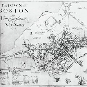
Framed Print : BOSTON MAP, 1722. Engraved facsimile by George G. Smith, 1835, of a map of Boston, Massachusetts, by John Bonner, first printed in 1722, showing changes in the citys topography through 1769


![]()
Framed Photos from Granger
BOSTON MAP, 1722. Engraved facsimile by George G. Smith, 1835, of a map of Boston, Massachusetts, by John Bonner, first printed in 1722, showing changes in the citys topography through 1769
BOSTON MAP, 1722.
Engraved facsimile by George G. Smith, 1835, of a map of Boston, Massachusetts, by John Bonner, first printed in 1722, showing changes in the citys topography through 1769
Granger holds millions of images spanning more than 25,000 years of world history, from before the Stone Age to the dawn of the Space Age
Media ID 6181542
1722 1769 1835 Bonner Boston Boston Harbor Charles River Colony Harbor Massachusetts Ship Smith Topography Typeface Facsimile
12"x10" Modern Frame
"Step back in time with our Boston Map Framed Print, an intriguing piece of historical cartography. This beautiful reproduction is an engraved facsimile of the original 1722 map of Boston, Massachusetts, created by John Bonner. The map, which was first printed in that year, offers a fascinating glimpse into the city's development during the 157-year period up to 1769. The map has been expertly crafted by George G. Smith in 1835, ensuring the finest details are captured. Hang this captivating work of art in your home or office to showcase the rich history of Boston. Presented in a high-quality frame, this framed print is a must-have for history enthusiasts and those who appreciate the beauty of historical maps." The Granger Collection, New York / The Granger Collection from Granger Art on Demand.
10x8 Print in an MDF Wooden Frame with 180 gsm Satin Finish Paper. Glazed using shatter proof thin plexi glass. Frame thickness is 1 inch and depth 0.75 inch. Fluted cardboard backing held with clips. Supplied ready to hang with sawtooth hanger and rubber bumpers. Spot clean with a damp cloth. Packaged foam wrapped in a card.
Contemporary Framed and Mounted Prints - Professionally Made and Ready to Hang
Estimated Image Size (if not cropped) is 25.4cm x 25.4cm (10" x 10")
Estimated Product Size is 30.5cm x 25.4cm (12" x 10")
These are individually made so all sizes are approximate
Artwork printed orientated as per the preview above, with landscape (horizontal) or portrait (vertical) orientation to match the source image.
FEATURES IN THESE COLLECTIONS
> Arts
> Artists
> S
> Charles John Smith
> Arts
> Artists
> S
> Charles Smith
> Arts
> Artists
> S
> George Smith
> Maps and Charts
> Early Maps
> Maps and Charts
> Related Images
> North America
> Related Images
> North America
> United States of America
> Massachusetts
> Boston
> Granger Art on Demand
> Boston Maps and Views
EDITORS COMMENTS
This print showcases a remarkable piece of history - the "BOSTON MAP, 1722". Engraved by George G. Smith in 1835, this facsimile of John Bonner's original map provides a fascinating glimpse into the changing topography of Boston, Massachusetts from its first printing in 1722 until 1769. The sepia-toned engraving beautifully captures the intricate details and delicate lines that make up this historical map. It transports us back to an early American era when Boston was still a burgeoning colony, with its bustling harbor and meandering Charles River prominently featured. As we study this meticulously crafted work of art, we can't help but marvel at how much the city has transformed over time. The evolving landscape is evident through subtle changes in typography and shifts in topographical elements. This visual representation serves as a testament to Boston's growth and development during those crucial years. Through this print, we are reminded of the significance that maps hold as invaluable tools for understanding our past and tracing our roots. It allows us to connect with our ancestors who navigated these streets centuries ago while also appreciating the rich history embedded within each street corner. Thanks to The Granger Collection's preservation efforts, we have access to such extraordinary pieces like this one - offering us an opportunity to explore and appreciate the evolution of cities like Boston throughout their storied histories.
MADE IN THE USA
Safe Shipping with 30 Day Money Back Guarantee
FREE PERSONALISATION*
We are proud to offer a range of customisation features including Personalised Captions, Color Filters and Picture Zoom Tools
SECURE PAYMENTS
We happily accept a wide range of payment options so you can pay for the things you need in the way that is most convenient for you
* Options may vary by product and licensing agreement. Zoomed Pictures can be adjusted in the Cart.