Framed Print > Granger Art on Demand > Maps
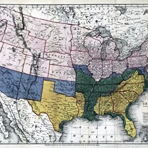
Framed Print : MAP: AMERICAN INDIANS. Map of linguistic stocks of American Indians. Lithograph, 1890


![]()
Framed Photos from Granger
MAP: AMERICAN INDIANS. Map of linguistic stocks of American Indians. Lithograph, 1890
MAP: AMERICAN INDIANS.
Map of linguistic stocks of American Indians. Lithograph, 1890
Granger holds millions of images spanning more than 25,000 years of world history, from before the Stone Age to the dawn of the Space Age
Media ID 12321325
American Indian Anthropology United States Linguistics
12"x10" Modern Frame
Add historical depth to your home or office with our Framed Prints from the Media Storehouse collection. This captivating piece features a rare 1890 lithograph map titled "MAP: AMERICAN INDIANS. Map of linguistic stocks of American Indians." by Granger, NYC, from The Granger Collection. This intriguing map showcases the linguistic stocks of American Indian tribes, offering a glimpse into the rich and diverse history of indigenous peoples. Bring this beautifully preserved piece of history into your space and spark intriguing conversations with the Map of American Indians Framed Print. Order now from Granger Art on Demand.
10x8 Print in an MDF Wooden Frame with 180 gsm Satin Finish Paper. Glazed using shatter proof thin plexi glass. Frame thickness is 1 inch and depth 0.75 inch. Fluted cardboard backing held with clips. Supplied ready to hang with sawtooth hanger and rubber bumpers. Spot clean with a damp cloth. Packaged foam wrapped in a card.
Contemporary Framed and Mounted Prints - Professionally Made and Ready to Hang
Estimated Image Size (if not cropped) is 25.4cm x 25.4cm (10" x 10")
Estimated Product Size is 25.4cm x 30.5cm (10" x 12")
These are individually made so all sizes are approximate
Artwork printed orientated as per the preview above, with landscape (horizontal) or portrait (vertical) orientation to match the source image.
EDITORS COMMENTS
This lithograph from 1890, titled "MAP: AMERICAN INDIANS" offers a fascinating glimpse into the linguistic diversity of American Indian tribes during that era. The intricate map showcases the various linguistic stocks spread across the United States, providing valuable insights into the rich tapestry of indigenous cultures. The lithograph is a testament to both the late 19th-century fascination with anthropology and an enduring appreciation for America's native heritage. Its detailed depiction invites viewers to explore and appreciate the incredible linguistic diversity that once flourished across this vast land. As we gaze upon this historical artifact, we are transported back in time, imagining how these diverse languages were spoken and passed down through generations. It serves as a reminder of the profound connection between language and culture, highlighting how each tribe had its unique way of communicating and understanding their world. Through this lithograph, Granger Art on Demand allows us to delve deeper into our nation's history by shedding light on lesser-known aspects of American Indian life. It encourages us to recognize and celebrate their contributions while fostering an understanding of their complex cultural landscape. With its meticulous details and vibrant colors, this print stands as a visual representation of America's indigenous past—a powerful tribute to those who came before us. As we admire it today, let us honor these diverse linguistic stocks by acknowledging their significance in shaping our shared heritage.
MADE IN THE USA
Safe Shipping with 30 Day Money Back Guarantee
FREE PERSONALISATION*
We are proud to offer a range of customisation features including Personalised Captions, Color Filters and Picture Zoom Tools
SECURE PAYMENTS
We happily accept a wide range of payment options so you can pay for the things you need in the way that is most convenient for you
* Options may vary by product and licensing agreement. Zoomed Pictures can be adjusted in the Cart.