Framed Print > Europe > United Kingdom > Scotland > Edinburgh > Edinburgh
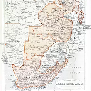
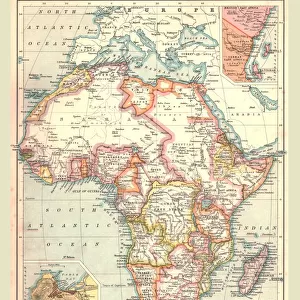
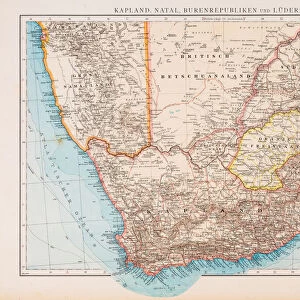
Framed Print : General Map of British South Africa, 1900. Creator: Unknown


![]()
Framed Photos from Heritage Images
General Map of British South Africa, 1900. Creator: Unknown
General Map of British South Africa, 1900. From " South Africa and the Transvaal War, Vol. I", by Louis Creswicke. [T. C. & E. C. Jack, Edinburgh, 1900]
Heritage Images features heritage image collections
Media ID 19780675
© The Print Collector/Heritage Images
Cartography Creswicke Jack Louis Louis Creswicke Map Making Mapmaking South Africa South Africa And The Transvaal War Tc And Ec Tc And Ec Jack British Empire
12"x10" Modern Frame
Discover the rich history of British South Africa with our stunning Framed Print of the General Map from the year 1900. This intriguing vintage map, taken from "South Africa and the Transvaal War, Vol. I" by Louis Creswicke, provides a captivating glimpse into the political landscape of the region during a pivotal period. The intricate details of the map are brought to life with our high-quality framing, making this a perfect addition to any home or office. Delve into the past and add a touch of history to your space with our General Map of British South Africa, 1900 Framed Print. Unknown creator, but known to ignite curiosity and conversation.
10x8 Print in an MDF Wooden Frame with 180 gsm Satin Finish Paper. Glazed using shatter proof thin plexi glass. Frame thickness is 1 inch and depth 0.75 inch. Fluted cardboard backing held with clips. Supplied ready to hang with sawtooth hanger and rubber bumpers. Spot clean with a damp cloth. Packaged foam wrapped in a card.
Contemporary Framed and Mounted Prints - Professionally Made and Ready to Hang
Estimated Image Size (if not cropped) is 25.4cm x 25.4cm (10" x 10")
Estimated Product Size is 25.4cm x 30.5cm (10" x 12")
These are individually made so all sizes are approximate
Artwork printed orientated as per the preview above, with landscape (horizontal) or portrait (vertical) orientation to match the source image.
FEATURES IN THESE COLLECTIONS
> Africa
> South Africa
> Maps
> Africa
> South Africa
> Related Images
> Arts
> Literature
> Illustration
> Arts
> Literature
> Europe
> United Kingdom
> Scotland
> Edinburgh
> Edinburgh
> Europe
> United Kingdom
> Scotland
> Lothian
> Edinburgh
> Maps and Charts
> British Empire Maps
> Maps and Charts
> Related Images
EDITORS COMMENTS
This print showcases a piece of history frozen in time - the "General Map of British South Africa, 1900". Created by an unknown artist, this map is a remarkable representation of the African continent during the colonial era. It was featured in Louis Creswicke's renowned book "South Africa and the Transvaal War, Vol. I", published by T. C. & E. C. Jack in Edinburgh in 1900. The map provides a comprehensive view of South Africa, highlighting its diverse geography and intricate cartography. It serves as a testament to the British Empire's influence on the region during that period, reflecting their colonial ambitions and territorial control. As we delve into this image, we are transported back to the late 19th century when exploration and colonization were at their peak. The artistry behind this illustration demonstrates meticulous attention to detail and precision in mapmaking techniques prevalent at that time. This print not only captures an important historical artifact but also represents a significant contribution to literature on African geography. Its presence evokes curiosity about how maps like these shaped perceptions of nations and territories within both academic circles and popular culture. Preserved by The Print Collector, this visual treasure allows us to appreciate the rich heritage of South Africa while contemplating its complex past marked by imperialism and colonialism.
MADE IN THE USA
Safe Shipping with 30 Day Money Back Guarantee
FREE PERSONALISATION*
We are proud to offer a range of customisation features including Personalised Captions, Color Filters and Picture Zoom Tools
SECURE PAYMENTS
We happily accept a wide range of payment options so you can pay for the things you need in the way that is most convenient for you
* Options may vary by product and licensing agreement. Zoomed Pictures can be adjusted in the Cart.