Framed Print > Arts > Artists > W > Christoph Weigel
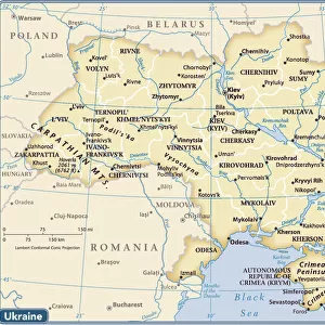
Framed Print : Map of Ukraine and surroundings of the Black Sea, um 1700. Creator: Weigel, Christoph, the Elder (1654-1725)
")

")

![]()
Framed Photos from Heritage Images
Map of Ukraine and surroundings of the Black Sea, um 1700. Creator: Weigel, Christoph, the Elder (1654-1725)
Map of Ukraine and surroundings of the Black Sea, um 1700. Private Collection
Heritage Images features heritage image collections
Media ID 36239609
© Fine Art Images/Heritage Images
Black Sea Cartography Christoph Copper Engraving Watercolour Ukraine Weigel Copper Engraving
12"x10" Modern Frame
Discover the rich history of Ukraine and the Black Sea region with our exquisite Framed Print from Media Storehouse. This beautifully detailed map, created by renowned cartographer Christoph Weigel the Elder in approximately 1700, showcases the intricate geography of the area during an intriguing period in history. Featuring the map of Ukraine and its surroundings, including the Black Sea, this vintage print is a captivating addition to any home or office. With its antique charm and authenticity, this Framed Print is not only a decorative piece but also a historical treasure. Bring a piece of the past into your space and transport yourself back in time with Media Storehouse's Framed Print of the Map of Ukraine and the Black Sea by Christoph Weigel the Elder.
10x8 Print in an MDF Wooden Frame with 180 gsm Satin Finish Paper. Glazed using shatter proof thin plexi glass. Frame thickness is 1 inch and depth 0.75 inch. Fluted cardboard backing held with clips. Supplied ready to hang with sawtooth hanger and rubber bumpers. Spot clean with a damp cloth. Packaged foam wrapped in a card.
Contemporary Framed and Mounted Prints - Professionally Made and Ready to Hang
Estimated Image Size (if not cropped) is 25.4cm x 25.4cm (10" x 10")
Estimated Product Size is 30.5cm x 25.4cm (12" x 10")
These are individually made so all sizes are approximate
Artwork printed orientated as per the preview above, with landscape (horizontal) or portrait (vertical) orientation to match the source image.
FEATURES IN THESE COLLECTIONS
> Arts
> Artists
> W
> Christoph Weigel
> Europe
> Ukraine
> Related Images
> Maps and Charts
> Related Images
EDITORS COMMENTS
Map of Ukraine and Surroundings of the Black Sea, um 1700 Creator: Christoph Weigel the Elder (1654-1725) Description: This exquisite map print, created by the renowned German cartographer Christoph Weigel the Elder around the year 1700, offers a captivating glimpse into the geographical knowledge of the time. The map focuses on the region of Ukraine and the surrounding areas of the Black Sea. The intricate details of the map are brought to life through the combination of copper engraving and delicate watercolor techniques. The Black Sea, a significant body of water in European and Asian history, is depicted with remarkable accuracy for the era. The map reveals the political divisions of the region at the time, with the territories of the Ottoman Empire, the Polish-Lithuanian Commonwealth, and the Crimean Khanate clearly marked. The major cities and fortifications along the coastline are also labeled, providing valuable insights into the strategic importance of these settlements. Christoph Weigel the Elder, a prolific cartographer, is known for his meticulous attention to detail and his innovative approach to mapmaking. This map is a testament to his mastery of the craft, showcasing both the artistic and informative aspects of cartography. The map's intricate design and rich historical context make it an invaluable addition to any collection of fine art images, particularly those focusing on cartography, history, or the graphic arts. Provenance: This map is part of a private collection, a testament to its rarity and historical significance. It serves as a reminder of the fascinating world of exploration and discovery that shaped our understanding of the world around us.
MADE IN THE USA
Safe Shipping with 30 Day Money Back Guarantee
FREE PERSONALISATION*
We are proud to offer a range of customisation features including Personalised Captions, Color Filters and Picture Zoom Tools
SECURE PAYMENTS
We happily accept a wide range of payment options so you can pay for the things you need in the way that is most convenient for you
* Options may vary by product and licensing agreement. Zoomed Pictures can be adjusted in the Cart.