Photographic Print > Arts > Artists > W > Christoph Weigel
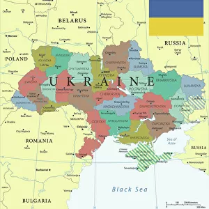
Photographic Print : Map of Ukraine and surroundings of the Black Sea, um 1700. Creator: Weigel, Christoph, the Elder (1654-1725)
")


![]()
Photo Prints from Heritage Images
Map of Ukraine and surroundings of the Black Sea, um 1700. Creator: Weigel, Christoph, the Elder (1654-1725)
Map of Ukraine and surroundings of the Black Sea, um 1700. Private Collection
Heritage Images features heritage image collections
Media ID 36239609
© Fine Art Images/Heritage Images
Black Sea Cartography Christoph Copper Engraving Watercolour Ukraine Weigel Copper Engraving
10"x8" Photo Print
Discover history with our exquisite Media Storehouse Photographic Print of a rare and intriguing map. This beautifully preserved antique map, created by renowned cartographer Christoph Weigel the Elder in approximately 1700, showcases the detailed cartography of Ukraine and the surrounding Black Sea region. With stunning clarity, explore the territories of Moldavia, Wallachia, and the Crimean Peninsula as they appeared centuries ago. Bring a piece of historical cartography into your home or office, and transport yourself back in time with this captivating and authentic work of art.
Photo prints are produced on Kodak professional photo paper resulting in timeless and breath-taking prints which are also ideal for framing. The colors produced are rich and vivid, with accurate blacks and pristine whites, resulting in prints that are truly timeless and magnificent. Whether you're looking to display your prints in your home, office, or gallery, our range of photographic prints are sure to impress. Dimensions refers to the size of the paper in inches.
Our Photo Prints are in a large range of sizes and are printed on Archival Quality Paper for excellent colour reproduction and longevity. They are ideal for framing (our Framed Prints use these) at a reasonable cost. Alternatives include cheaper Poster Prints and higher quality Fine Art Paper, the choice of which is largely dependant on your budget.
Estimated Product Size is 25.4cm x 20.3cm (10" x 8")
These are individually made so all sizes are approximate
Artwork printed orientated as per the preview above, with landscape (horizontal) orientation to match the source image.
FEATURES IN THESE COLLECTIONS
> Arts
> Artists
> W
> Christoph Weigel
> Europe
> Ukraine
> Related Images
> Maps and Charts
> Related Images
EDITORS COMMENTS
Map of Ukraine and Surroundings of the Black Sea, um 1700 Creator: Christoph Weigel the Elder (1654-1725) Description: This exquisite map print, created by the renowned German cartographer Christoph Weigel the Elder around the year 1700, offers a captivating glimpse into the geographical knowledge of the time. The map focuses on the region of Ukraine and the surrounding areas of the Black Sea. The intricate details of the map are brought to life through the combination of copper engraving and delicate watercolor techniques. The Black Sea, a significant body of water in European and Asian history, is depicted with remarkable accuracy for the era. The map reveals the political divisions of the region at the time, with the territories of the Ottoman Empire, the Polish-Lithuanian Commonwealth, and the Crimean Khanate clearly marked. The major cities and fortifications along the coastline are also labeled, providing valuable insights into the strategic importance of these settlements. Christoph Weigel the Elder, a prolific cartographer, is known for his meticulous attention to detail and his innovative approach to mapmaking. This map is a testament to his mastery of the craft, showcasing both the artistic and informative aspects of cartography. The map's intricate design and rich historical context make it an invaluable addition to any collection of fine art images, particularly those focusing on cartography, history, or the graphic arts. Provenance: This map is part of a private collection, a testament to its rarity and historical significance. It serves as a reminder of the fascinating world of exploration and discovery that shaped our understanding of the world around us.
MADE IN THE USA
Safe Shipping with 30 Day Money Back Guarantee
FREE PERSONALISATION*
We are proud to offer a range of customisation features including Personalised Captions, Color Filters and Picture Zoom Tools
SECURE PAYMENTS
We happily accept a wide range of payment options so you can pay for the things you need in the way that is most convenient for you
* Options may vary by product and licensing agreement. Zoomed Pictures can be adjusted in the Cart.