Framed Print > Arts > Photorealistic artworks > Detailed art pieces > Masterful detailing in art
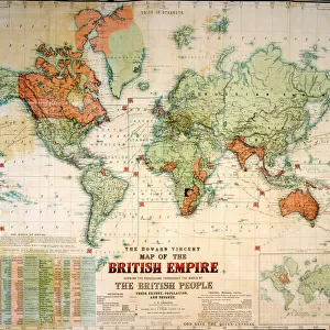
Framed Print : Map of The British Empire by Fullarton & Co 1850


![]()
Framed Photos from MapSeeker
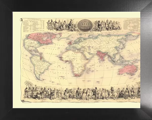
Map of The British Empire by Fullarton & Co 1850
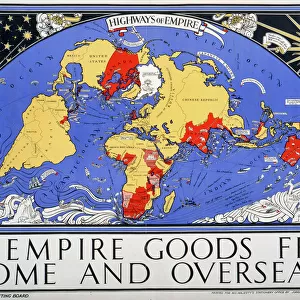
Fine reproduction of the attractive World Map showing the British Empire. Mapmaker John Bartholomew and publishers Fullarton were then the first to use red or pink to indicate British possessions around the world, a feature which became common to most maps for the next 100 years. In this map, which dates back to the 1850AEs states in notes at the top of the map oThe British Possessions are engraved in a bolder character and coloured Redo. The map is also framed by idealized images of friendly encounters between British colonists and indigenous inhabitants in four different parts of the Globe: Australia, North America, British Asia, East Inidican islands and the Cape Colony in Southern Africa. It is highly detailed and decorative and it appeared in FullartonAEs Royal Illustrated Atlas which was first published in 1864 after being issued in 27 parts from 1854-62. The tables shown include the size and population of the British possessions at the time of publication
Welcome to the Mapseeker Image library and enter an historic gateway to one of the largest on-line collections of Historic Maps, Nostalgic Views, Vista's and Panorama's from a World gone by.
Media ID 20347041
Map Of The World Old Map Of The World The World World Map British Empire
18"x14" Modern Frame
Step back in time with our exquisite Framed Print of the "Map of The British Empire by Fullarton & Co 1850" from MapSeeker. This fine reproduction showcases an intricately detailed World Map, where the British Empire is depicted in bold red and pink hues, making it the first of its kind by renowned mapmaker John Bartholomew and publishers Fullarton. An essential addition to any home or office, this timeless piece is meticulously framed to preserve its historical charm and beauty for generations to come.
16x12 Print in an MDF Wooden Frame with 180 gsm Satin Finish Paper. Glazed using shatter proof thin plexiglass. Frame thickness is 1 inch and depth 0.75 inch. Fluted cardboard backing held with clips. Supplied ready to hang with sawtooth hanger and rubber bumpers. Spot clean with a damp cloth. Packaged foam wrapped in a card.
Contemporary Framed and Mounted Prints - Professionally Made and Ready to Hang
Estimated Image Size (if not cropped) is 40.6cm x 35.6cm (16" x 14")
Estimated Product Size is 45.7cm x 35.6cm (18" x 14")
These are individually made so all sizes are approximate
Artwork printed orientated as per the preview above, with landscape (horizontal) orientation to match the source image.
FEATURES IN THESE COLLECTIONS
> Arts
> Photorealistic artworks
> Detailed art pieces
> Masterful detailing in art
> Asia
> East Timor
> Maps
> Asia
> East Timor
> Related Images
> Maps and Charts
> British Empire Maps
> Maps and Charts
> Related Images
> Maps and Charts
> World
EDITORS COMMENTS
This print showcases a fine reproduction of the Map of The British Empire by Fullarton & Co from 1850. Renowned mapmaker John Bartholomew and publishers Fullarton were pioneers in their use of red or pink to highlight British possessions across the globe, a convention that would endure for the next century. This particular map, dating back to the 1850s, proudly declares at its summit that "The British Possessions are engraved in a bolder character and coloured Red". What sets this map apart is its exquisite attention to detail and decorative elements. Framing the edges are idyllic depictions of harmonious encounters between British colonists and indigenous inhabitants in various regions: Australia, North America, British Asia, East Indian islands, and the Cape Colony in Southern Africa. These images serve as reminders of Britain's global influence during this era. Originally featured in Fullarton's Royal Illustrated Atlas published in 1864 (after being issued in parts from 1854-62), this map not only provides geographical information but also includes tables presenting the size and population of each British possession at that time. With its historical significance as one of the earliest maps utilizing color-coded indicators for colonial territories and its striking visual appeal through intricate illustrations, this print offers an intriguing glimpse into an era when Britannia ruled over vast expanses around the world.
MADE IN THE USA
Safe Shipping with 30 Day Money Back Guarantee
FREE PERSONALISATION*
We are proud to offer a range of customisation features including Personalised Captions, Color Filters and Picture Zoom Tools
SECURE PAYMENTS
We happily accept a wide range of payment options so you can pay for the things you need in the way that is most convenient for you
* Options may vary by product and licensing agreement. Zoomed Pictures can be adjusted in the Cart.