Framed Print > Europe > United Kingdom > Wales > Maps
Framed Print : Map of England and France, 1154


![]()
Framed Photos from North Wind
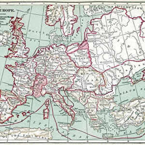
Map of England and France, 1154
England and France at the accession of Henry II, 1154.
Color lithograph reproduction of a 19th-century illustration
North Wind Picture Archives brings history to life with stock images and hand-colored illustrations
Media ID 5879168
© North Wind Picture Archives
100 Years War 1100s 12th Century British Eire England English Europe Family France French Great Britain Ireland Medieval Middle Ages Wales Angevin Anjou Henry Curtmantle Henry Ii King Henry Ii Plantagenet
12"x10" Modern Frame
Step back in time with our exquisite Media Storehouse Framed Print featuring a captivating map of England and France in 1154, as depicted in the North Wind Picture Archives. This stunning color lithograph reproduction brings to life the historical landscape of Europe during the reign of Henry II. Transport yourself to another era with this beautiful and authentic piece, expertly framed and ready to hang in your home or office. Add a touch of history and character to your space with our Framed Print of England and France, 1154.
10x8 Print in an MDF Wooden Frame with 180 gsm Satin Finish Paper. Glazed using shatter proof thin plexi glass. Frame thickness is 1 inch and depth 0.75 inch. Fluted cardboard backing held with clips. Supplied ready to hang with sawtooth hanger and rubber bumpers. Spot clean with a damp cloth. Packaged foam wrapped in a card.
Contemporary Framed and Mounted Prints - Professionally Made and Ready to Hang
Estimated Image Size (if not cropped) is 25.4cm x 25.4cm (10" x 10")
Estimated Product Size is 25.4cm x 30.5cm (10" x 12")
These are individually made so all sizes are approximate
Artwork printed orientated as per the preview above, with landscape (horizontal) or portrait (vertical) orientation to match the source image.
FEATURES IN THESE COLLECTIONS
> Arts
> Art Movements
> Medieval Art
> Europe
> Republic of Ireland
> Maps
> Europe
> United Kingdom
> England
> Maps
> Europe
> United Kingdom
> Maps
> Europe
> United Kingdom
> Wales
> Maps
> Europe
> United Kingdom
> Wales
> Posters
> Europe
> United Kingdom
> Wales
> Related Images
> North Wind Picture Archives
> British history
> North Wind Picture Archives
> Maps
EDITORS COMMENTS
This color lithograph reproduction showcases a remarkable illustration of the "Map of England and France, 1154". Transporting us back to the medieval era, this vintage print captures the essence of heritage and tradition. The map depicts England and France at the accession of Henry II in 1154, offering a glimpse into the political landscape of that time. With intricate details and vibrant colors, this artwork beautifully portrays the territories ruled by Henry II's dynasty, known as Plantagenet. From Great Britain to Ireland, Wales to Anjou, it highlights the vast dominions under his reign. This visual representation takes us on a journey through history when English and French influences intertwined during an era marked by significant events. The map not only serves as a historical artifact but also evokes curiosity about Europe in the 12th century. It reminds us of King Henry II himself - often referred to as Henry Curtmantle - who played a crucial role in shaping both English and French history. As we admire this piece of art from North Wind Picture Archives, we are reminded of its significance beyond aesthetics. It symbolizes centuries-old conflicts like the Angevin Empire's struggles against France during events such as the Hundred Years' War. A true testament to our shared past, this illustration invites us to explore one of history's most intriguing periods: The Middle Ages.
MADE IN THE USA
Safe Shipping with 30 Day Money Back Guarantee
FREE PERSONALISATION*
We are proud to offer a range of customisation features including Personalised Captions, Color Filters and Picture Zoom Tools
SECURE PAYMENTS
We happily accept a wide range of payment options so you can pay for the things you need in the way that is most convenient for you
* Options may vary by product and licensing agreement. Zoomed Pictures can be adjusted in the Cart.