Framed Print > Europe > Portugal > Maps
Framed Print : Medieval Spain and Portugal map


Framed Photos from North Wind
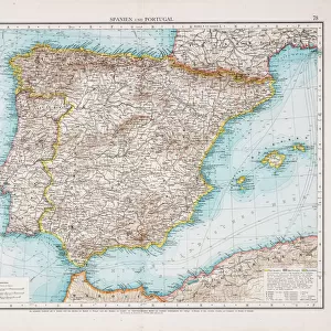
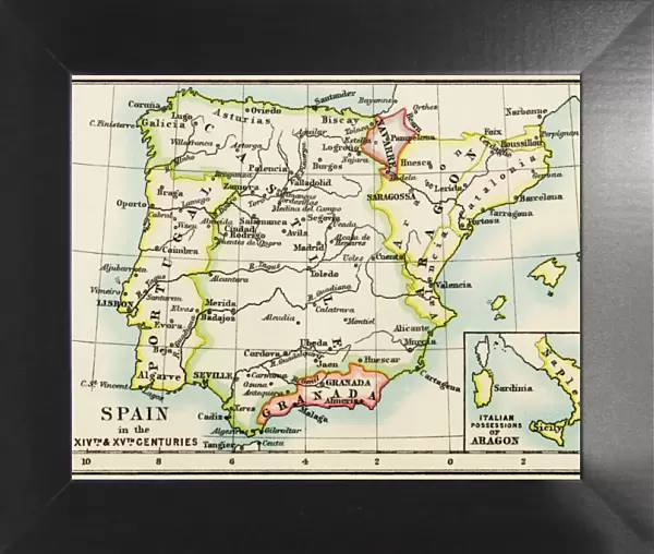
Medieval Spain and Portugal map
Map of the Iberian Peninsula in the 1300s and 1400s.
Printed color lithograph reproduction of a 19th-century illustration
North Wind Picture Archives brings history to life with stock images and hand-colored illustrations
Media ID 5882217
© North Wind Picture Archives
1300s 1400s 14th Century 15th Century Europe European Granada Medieval Middle Ages Moors Portugal Portuguese Spain Spanish Aragon Castile Gibraltar Iberia Iberian Peninsula Navarra
12"x10" Modern Frame
Discover the rich history of Medieval Spain and Portugal with our stunning Framed Print from the Media Storehouse collection. This beautifully detailed map, sourced from North Wind Picture Archives, transports you back in time to the 1300s and 1400s. The intricately designed illustration showcases the Iberian Peninsula during this era, bringing to life the complex tapestry of history. Our Framed Print is a color lithograph reproduction of a 19th-century original, ensuring the highest quality and authenticity. Add this captivating piece to your home or office to ignite curiosity and inspire learning. A perfect addition to any history enthusiast's collection.
10x8 Print in an MDF Wooden Frame with 180 gsm Satin Finish Paper. Glazed using shatter proof thin plexi glass. Frame thickness is 1 inch and depth 0.75 inch. Fluted cardboard backing held with clips. Supplied ready to hang with sawtooth hanger and rubber bumpers. Spot clean with a damp cloth. Packaged foam wrapped in a card.
Contemporary Framed and Mounted Prints - Professionally Made and Ready to Hang
Estimated Image Size (if not cropped) is 25.4cm x 25.4cm (10" x 10")
Estimated Product Size is 30.5cm x 25.4cm (12" x 10")
These are individually made so all sizes are approximate
Artwork printed orientated as per the preview above, with landscape (horizontal) or portrait (vertical) orientation to match the source image.
FEATURES IN THESE COLLECTIONS
> Arts
> Art Movements
> Medieval Art
> Europe
> Portugal
> Related Images
> Europe
> Spain
> Related Images
> Maps and Charts
> Related Images
> North Wind Picture Archives
> Maps
EDITORS COMMENTS
This print takes us on a journey back in time to the medieval era of Spain and Portugal. With its vibrant colors and intricate details, it beautifully captures the essence of the Iberian Peninsula during the 1300s and 1400s. The map showcases the rich history and heritage of this region, highlighting key cities such as Granada, Gibraltar, Aragon, Castile, Navarra, and more. Each city is marked with precision, allowing us to trace the footsteps of ancient civilizations that once thrived here. As we explore this vintage illustration, we are transported to a world where traditional architecture meets European charm. The artistry behind this lithograph reproduction truly brings out the grandeur of medieval Spain and Portugal. One cannot help but marvel at how this map encapsulates centuries of cultural exchange between Christians and Moors. It serves as a testament to their coexistence during these tumultuous times in history. Whether you are an art enthusiast or a history buff, this print offers a glimpse into Europe's fascinating past. It serves as a reminder that even amidst political turmoil and territorial disputes, beauty can be found in every corner of our shared human experience
MADE IN THE USA
Safe Shipping with 30 Day Money Back Guarantee
FREE PERSONALISATION*
We are proud to offer a range of customisation features including Personalised Captions, Color Filters and Picture Zoom Tools
SECURE PAYMENTS
We happily accept a wide range of payment options so you can pay for the things you need in the way that is most convenient for you
* Options may vary by product and licensing agreement. Zoomed Pictures can be adjusted in the Cart.