Framed Print > Universal Images Group (UIG) > Universal Images Group > Satellite and Aerial > Planet Observer 5
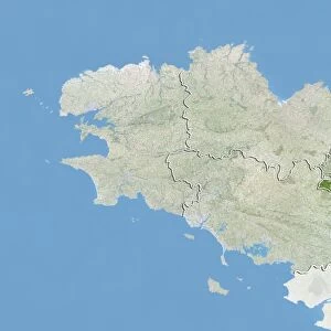
Framed Print : Departement of Ille-et-Vilaine, France, Relief Map


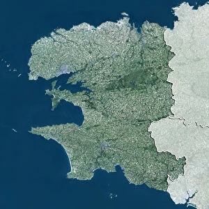
![]()
Framed Photos from Universal Images Group (UIG)
Departement of Ille-et-Vilaine, France, Relief Map
Relief map of the departement of Ille-et-Vilaine, France. It is bordered by the English Channel to the north. This image was compiled from data acquired by LANDSAT 5 & 7 satellites combined with elevation data
Universal Images Group (UIG) manages distribution for many leading specialist agencies worldwide
Media ID 9611987
© Planet Observer
Brittany Coastline Geographical Border Relief Map Shore Ille Et Vilaine Satellite View
12"x10" Modern Frame
Discover the beauty of Ille-et-Vilaine, France, with our stunning Framed Print from Media Storehouse. This exquisite relief map, sourced from Universal Images Group (UIG), showcases the intricate topography of the department. Bordered by the English Channel to the north, this map is a testament to the diverse and captivating geography of the region. Compiled from data acquired by LANDSAT 5 & 7 satellites, this print provides an accurate and visually appealing representation of the land. Bring a piece of France into your home or office with this unique and thoughtful addition to your decor.
10x8 Print in an MDF Wooden Frame with 180 gsm Satin Finish Paper. Glazed using shatter proof thin plexi glass. Frame thickness is 1 inch and depth 0.75 inch. Fluted cardboard backing held with clips. Supplied ready to hang with sawtooth hanger and rubber bumpers. Spot clean with a damp cloth. Packaged foam wrapped in a card.
Contemporary Framed and Mounted Prints - Professionally Made and Ready to Hang
Estimated Image Size (if not cropped) is 25.4cm x 25.4cm (10" x 10")
Estimated Product Size is 25.4cm x 30.5cm (10" x 12")
These are individually made so all sizes are approximate
Artwork printed orientated as per the preview above, with landscape (horizontal) or portrait (vertical) orientation to match the source image.
EDITORS COMMENTS
This print showcases the stunning relief map of the Departement of Ille-et-Vilaine in France. Located in the beautiful region of Brittany, this departement is bordered by the majestic English Channel to its north. The intricate details and vibrant colors of this image were meticulously compiled from data acquired by LANDSAT 5 & 7 satellites, combined with elevation data. The photograph provides a bird's-eye view of the physical geography and topography of Ille-et-Vilaine. From its picturesque coastline to its undulating landscapes, every contour is clearly visible, making it an invaluable tool for cartographers and geographers alike. The absence of people in this image allows us to fully appreciate nature's artistry at play. As we gaze upon this vertical composition, we are transported into a world where geographical borders dissolve, leaving only awe-inspiring beauty behind. Whether you're an avid photographer or simply fascinated by maps and satellite views, this print offers a unique perspective on one of France's most enchanting regions. Its color palette evokes a sense of tranquility while simultaneously igniting our curiosity about the secrets hidden within Ille-et-Vilaine's diverse terrain
MADE IN THE USA
Safe Shipping with 30 Day Money Back Guarantee
FREE PERSONALISATION*
We are proud to offer a range of customisation features including Personalised Captions, Color Filters and Picture Zoom Tools
SECURE PAYMENTS
We happily accept a wide range of payment options so you can pay for the things you need in the way that is most convenient for you
* Options may vary by product and licensing agreement. Zoomed Pictures can be adjusted in the Cart.