Home > Europe > United Kingdom > England > London > Transport > Railway
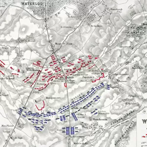
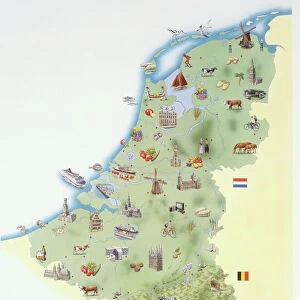
A General Map of Belgium, Indicating the Fortified Towns, 1919

![]()
Wall Art and Photo Gifts from Heritage Images
A General Map of Belgium, Indicating the Fortified Towns, 1919
A General Map of Belgium, Indicating the Fortified Towns, 1919. Map of territory in which fighting took place during the First World War, also showing principal railways. From " The History of the Great European War: its causes and effects", Vol. II, by W. Stanley Macbean Knight. [Caxton Pulishing Company, Limited, London, 1919]
Heritage Images features heritage image collections
Media ID 19047523
© The Print Collector/Heritage Images
Brussels Caxton Publishing Company Caxton Pulishing Company Caxton Pulishing Company Lim Caxton Pulishing Company Limited Caxton Pulishing Company Ltd Fortified Knight Limited London Geographical Institute Luxembourg Stanley Macbean Stanley Macbean Knight Theatre Of War W Stanley Macbean W Stanley Macbean Knight William Stanley Macbean William Stanley Macbean Knight 1st World War
FEATURES IN THESE COLLECTIONS
> Europe
> Luxembourg
> Maps
> Europe
> Luxembourg
> Railways
> Europe
> United Kingdom
> England
> London
> Art
> Theatre
> Europe
> United Kingdom
> England
> London
> Transport
> Railway
EDITORS COMMENTS
This print titled "A General Map of Belgium, Indicating the Fortified Towns, 1919" offers a glimpse into the aftermath of the First World War. The map, originally featured in W. Stanley Macbean Knight's book "The History of the Great European War: its causes and effects" provides an intricate overview of Belgium during this tumultuous period. With vibrant colors and precise detailing, this historical artifact showcases not only the geographical landscape but also highlights significant fortified towns that played a crucial role in the war. From Brussels to Luxembourg, each location marked on this map represents a theater of war where intense fighting took place. As we examine this piece closely, it becomes apparent that transportation was vital during these times. Principal railways are prominently displayed on the map, emphasizing their importance in supplying troops and resources across Belgium's vast territory. This print serves as a poignant reminder of the devastating impact that World War I had on nations like Belgium. It encapsulates both the physical scars left by warfare and symbolizes resilience as these fortified towns stood strong amidst chaos. Preserved by The Print Collector from Caxton Publishing Company Limited in London, this image allows us to reflect upon history while appreciating how far we have come since those dark days. It is through such visual records that we can honor those who fought bravely and ensure their sacrifices are never forgotten.
MADE IN THE USA
Safe Shipping with 30 Day Money Back Guarantee
FREE PERSONALISATION*
We are proud to offer a range of customisation features including Personalised Captions, Color Filters and Picture Zoom Tools
SECURE PAYMENTS
We happily accept a wide range of payment options so you can pay for the things you need in the way that is most convenient for you
* Options may vary by product and licensing agreement. Zoomed Pictures can be adjusted in the Cart.