Home > Asia > Mongolia > Maps
Map of the Far East of the USSR, Northern China (Manchuria) and Mongolia, 1930. Creator: Unknown
 and Mongolia, 1930. Creator: Unknown")
![]()
Wall Art and Photo Gifts from Heritage Images
Map of the Far East of the USSR, Northern China (Manchuria) and Mongolia, 1930. Creator: Unknown
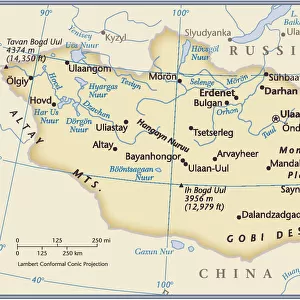
Map of the Far East of the USSR, Northern China (Manchuria) and Mongolia, 1930. This Soviet-era map is intended to serve a propaganda purpose. On the top and bottom are the slogans: "For the strengthening of the military-sanitary fund of the Red Cross"; "Citizens of the USSR must remember the Chinese adventure of 1929"; and " The Army and the Red Cross--together serving the defense of the USSR." Shown on the map are international borders, administrative borders on the territory of the USSR, population centers, railroad stations, and roads. The inset in the lower right is a schematic map of southern China. The portraits on the left and right sides of the map are of V.K. Bliukher, an important Soviet military commander who later was killed in Stalin's Great Purge in the 1930s, and a Comrade Simanovskii, about which little is known
Heritage Images features heritage image collections
Media ID 35130591
© Heritage Art/Heritage Images
Border Borders Cartographic Cartography China Asia Humanitarian Aid Irkutsk Rossiya Russia Map Making Mapmaking Military Commander Mongolia Propaganda Railroad Railway Station Red Cross Roads Russian Federation Slogan Soviet Soviet Union Station Territorial Territory Thoroughfare Train Station Union Of Soviet Socialist Republics Ussr Armed Services Meeting Of Frontiers Purge
FEATURES IN THESE COLLECTIONS
> Asia
> Mongolia
> Related Images
> Maps and Charts
> Early Maps
> Maps and Charts
> Related Images
EDITORS COMMENTS
This print showcases a Soviet-era map titled "Map of the Far East of the USSR, Northern China (Manchuria) and Mongolia, 1930." Created by an unknown artist, this map was undoubtedly intended to serve a propaganda purpose. The top and bottom sections are adorned with powerful slogans such as "For the strengthening of the military-sanitary fund of the Red Cross" and "Citizens of the USSR must remember the Chinese adventure of 1929," emphasizing both military preparedness and historical events.
The map itself provides a comprehensive depiction of international borders, administrative divisions within the USSR, population centers, railroad stations, and roads. A schematic inset in the lower right corner focuses on southern China. This detailed cartographic representation offers valuable insights into geographical features and transportation networks during that era.
Flanking either side of this intriguing map are portraits; one is V.K. Bliukher, an esteemed Soviet military commander who tragically fell victim to Stalin's Great Purge in the 1930s. The other portrait depicts Comrade Simanovskii—an enigmatic figure about whom little information is available.
This photograph print from Heritage Images not only captures a significant piece of history but also highlights various themes including aid efforts, armed forces' role in defense, railway infrastructure development for transport purposes, territorial boundaries shaping geopolitical landscapes between Russia (then known as USSR), Northern China (Manchuria), and Mongolia.
As we delve into this image's rich details—its colors reflecting its time—the viewer gains insight into early twentieth-century cartography while contemplating how propaganda played a crucial role in shaping public opinion during that period.
MADE IN THE USA
Safe Shipping with 30 Day Money Back Guarantee
FREE PERSONALISATION*
We are proud to offer a range of customisation features including Personalised Captions, Color Filters and Picture Zoom Tools
SECURE PAYMENTS
We happily accept a wide range of payment options so you can pay for the things you need in the way that is most convenient for you
* Options may vary by product and licensing agreement. Zoomed Pictures can be adjusted in the Cart.