Home > Arts > Artists > W > Nicolaes Witsen
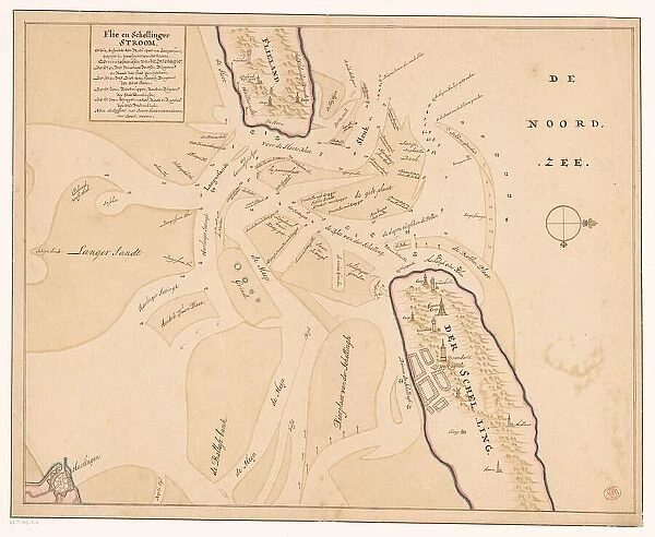
Map of Vlieland, Terschelling and the surrounding sandbanks, 1708 or later. Creator: Isaak de Graaf
![]()

Wall Art and Photo Gifts from Heritage Images
Map of Vlieland, Terschelling and the surrounding sandbanks, 1708 or later. Creator: Isaak de Graaf
Map of Vlieland, Terschelling and the surrounding sandbanks, 1708 or later. At top left the title: Flie en Schellinger stroom [stream], and a comment: Note the cyffers with black, mean fathoms [vadem]; With red, feet'. Possibly by Isaac de Graaf
Heritage Images features heritage image collections
Media ID 36332985
© Heritage Art/Heritage Images
Cartography Coastline Dike Dikes Dyke Dykes Flood Defence Island Islands Map Making Mapmaking North Sea Rivers Sepia Channels Friesland Netherlands Nicolaes Witsen Vlieland Watercolour Paint Witsen
FEATURES IN THESE COLLECTIONS
> Arts
> Artists
> W
> Nicolaes Witsen
> Arts
> Landscape paintings
> Coastal landscapes
> Nature-inspired artwork
> Arts
> Landscape paintings
> Waterfall and river artworks
> Nature-inspired paintings
> Arts
> Landscape paintings
> Waterfall and river artworks
> River artworks
> Arts
> Watercolor paintings
> Nature-inspired watercolors
> Waterfall and river scenes in
> Europe
> Netherlands
> Maps
> Europe
> Netherlands
> Posters
> Europe
> Netherlands
> Related Images
> Europe
> Netherlands
> Rivers
EDITORS COMMENTS
This map print, created by Isaak de Graaf in the 18th century, showcases the intricate detail of the coastal regions of Vlieland, Terschelling, and the surrounding sandbanks in the Netherlands. The title at the top left, 'Flie en Schellinger stroom' (Stream of Vlieland and Terschelling), provides a clear identification of the featured area. The map is an essential record of the geography of the region during this time, with annotations indicating depth measurements in both fathoms (black) and feet (red). Isaac de Graaf's masterful use of ink and sepia watercolor paints brings the map to life, capturing the natural beauty and complex network of channels, rivers, and coastline. The map also highlights the importance of dikes and flood defenses, which were crucial for the protection of the low-lying lands from the North Sea. This map is a testament to the rich cartographic heritage of the Netherlands, with influences from notable figures such as Nicolaes Cornelisz Witsen. The map is a valuable resource for historians, geographers, and anyone interested in the history and geography of the region. The Rijksmuseum in Amsterdam houses this precious piece of art and cultural heritage, inviting us to explore the intricacies of the Dutch coastline as it appeared over three centuries ago.
MADE IN THE USA
Safe Shipping with 30 Day Money Back Guarantee
FREE PERSONALISATION*
We are proud to offer a range of customisation features including Personalised Captions, Color Filters and Picture Zoom Tools
SECURE PAYMENTS
We happily accept a wide range of payment options so you can pay for the things you need in the way that is most convenient for you
* Options may vary by product and licensing agreement. Zoomed Pictures can be adjusted in the Cart.

