Home > Europe > United Kingdom > England > London > Sights > New River
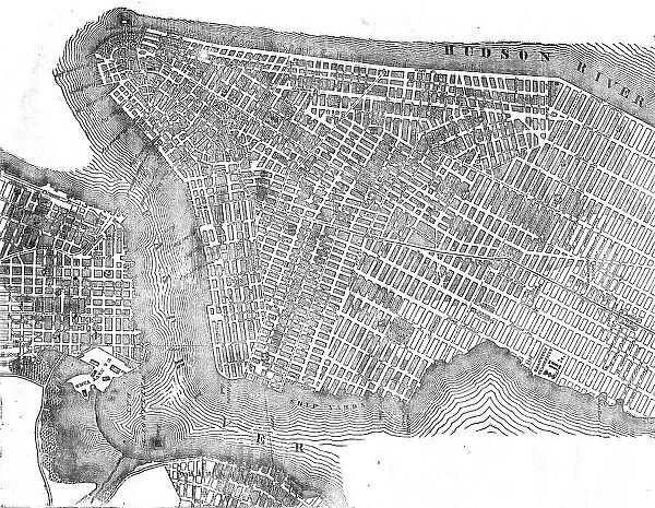
Plan of New York, 1854. Creator: Unknown
![]()

Wall Art and Photo Gifts from Heritage Images
Plan of New York, 1854. Creator: Unknown
Plan of New York, 1854. From "Cassell's Illustrated Family Paper; London Weekly 31 Dec 1853 to 30 Dec 1854"
Heritage Images features heritage image collections
Media ID 36249231
© The Print Collector/Heritage Images
Cassells Illustrated Family Paper East River Grid Hudson Hudson River New York Plan River Hudson Street Plan
FEATURES IN THESE COLLECTIONS
> Arts
> Landscape paintings
> Waterfall and river artworks
> River artworks
> Europe
> United Kingdom
> England
> London
> Sights
> New River
> Maps and Charts
> Related Images
> North America
> United States of America
> Maps
> North America
> United States of America
> New York
> New York
> Maps
> North America
> United States of America
> New York
> Related Images
EDITORS COMMENTS
This image, titled 'Plan of New York,' dates back to 1854 and was originally published in Cassell's Illustrated Family Paper, a weekly publication based in London. The creator of this intriguing map remains unknown, adding to its allure. The map offers a bird's-eye view of New York City as it appeared during the mid-19th century. The meticulously detailed illustration showcases the city's street grid, with the Hudson River and East River acting as its natural borders. The Hudson River, a major geographical feature, is depicted with several ships anchored along its shores, reflecting the bustling maritime activity that defined New York during this period. The map reveals the location of various landmarks, including City Hall, the Battery, and the Five Points area, which was infamous for its dense population and criminal activity. The map also highlights the city's division into wards, providing insight into the administrative structure of New York during this time. This rare and captivating print, with its intricate details and historical significance, offers a unique glimpse into the urban landscape of New York City during the 19th century. It serves as a testament to the city's rich history and its transformation from a bustling port city to a global metropolis.
MADE IN THE USA
Safe Shipping with 30 Day Money Back Guarantee
FREE PERSONALISATION*
We are proud to offer a range of customisation features including Personalised Captions, Color Filters and Picture Zoom Tools
FREE COLORIZATION SERVICE
You can choose advanced AI Colorization for this picture at no extra charge!
SECURE PAYMENTS
We happily accept a wide range of payment options so you can pay for the things you need in the way that is most convenient for you
* Options may vary by product and licensing agreement. Zoomed Pictures can be adjusted in the Cart.


