Jigsaw Puzzle > Arts > Artists > W > Thomas Webster
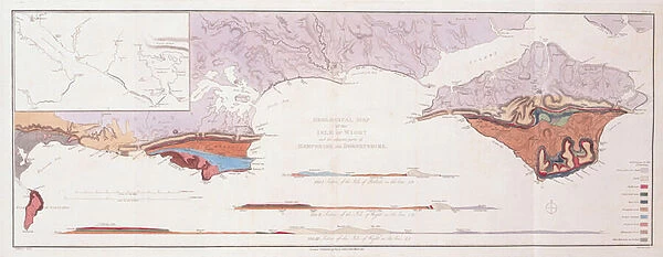
Jigsaw Puzzle : Geological Map and Sections of the Isle of Wight and the Adjacent Parts of Hampshire and Dorsetshire, 1816 (hand-coloured engraving)
![]()

Jigsaw Puzzles from Fine Art Finder
Geological Map and Sections of the Isle of Wight and the Adjacent Parts of Hampshire and Dorsetshire, 1816 (hand-coloured engraving)
1765217 Geological Map and Sections of the Isle of Wight and the Adjacent Parts of Hampshire and Dorsetshire, 1816 (hand-coloured engraving) by Webster, Thomas (1772-1844); 40x76 cm; Society of Antiquaries of London, UK; (add.info.: Sir Henry Charles Englefield (c. 1752-1822) was President of the Society of Antiquaries of London in 1811. From 1811 to 1813 Webster worked on a commission for Englefield on the Isle of Wight, the result of which was the first hand-coloured geological map of the Isle of Wight and parts of Hampshire and Dorset.)
Media ID 25164650
© Bridgeman Images
Antiquarian Dorset Geological Geology Hampshire Isle Of Wight South East South West Thomas Webster West Country Regency
Jigsaw Puzzle (1014 Pieces)
Discover the wonders of geology with our captivating jigsaw puzzle from Media Storehouse, featuring the intricately detailed hand-coloured engraving of "Geological Map and Sections of the Isle of Wight and the Adjacent Parts of Hampshire and Dorsetshire," published in 1816. This fascinating puzzle, sourced from Bridgeman Images through Fine Art Finder (1765217), invites you to piece together a piece of history. Explore the intricate geological formations and sections of this historic map, providing a glimpse into the rich geological history of the Isle of Wight and its surrounding areas. Ideal for enthusiasts of history, geology, and puzzle-solving, this challenging yet rewarding puzzle promises an engaging experience for all ages.
Made in the USA, 1014-piece puzzles measure 20" x 30" (50.8 x 76.2 cm). Every puzzle is meticulously printed on glossy photo paper, which has a strong 1.33 mm thickness. Delivered in a black storage cardboard box, these puzzles are both stylish and practical. (Note: puzzles contain small parts and are not suitable for children under 3 years of age.)
Jigsaw Puzzles are an ideal gift for any occasion
Estimated Product Size is 76cm x 50.8cm (29.9" x 20")
These are individually made so all sizes are approximate
Artwork printed orientated as per the preview above, with landscape (horizontal) orientation to match the source image.
FEATURES IN THESE COLLECTIONS
> Fine Art Finder
> Artists
> Augustus Welby Northmore Pugin
> Fine Art Finder
> Artists
> Thomas Webster
> Fine Art Finder
> Maps (celestial & Terrestrial)
> Arts
> Artists
> H
> Thomas Hand
> Arts
> Artists
> H
> Thomas Henry
> Arts
> Artists
> W
> Thomas Webster
> Europe
> United Kingdom
> England
> Dorset
> Related Images
> Europe
> United Kingdom
> England
> Hampshire
> Related Images
> Europe
> United Kingdom
> England
> Maps
> Europe
> United Kingdom
> Maps
> Maps and Charts
> Geological Map
EDITORS COMMENTS
This hand-coloured engraving from 1816 showcases the Geological Map and Sections of the Isle of Wight and the Adjacent Parts of Hampshire and Dorsetshire. Created by Thomas Webster, this masterpiece measures 40x76 cm and is housed in the prestigious Society of Antiquaries of London. Commissioned by Sir Henry Charles Englefield, President of the Society at that time, this map represents a significant milestone in geological cartography. It was meticulously crafted during Webster's extensive exploration on the Isle of Wight between 1811 and 1813. The intricate details captured in this print offer a glimpse into England's rich geological history. From its regency charm to its coastal allure, every inch tells a story about the formation and evolution of these lands. The map not only reveals fascinating insights into ancient rock formations but also highlights key features along the shoreline. Webster's skilled craftsmanship brings life to this historical document, allowing viewers to appreciate both its scientific significance and artistic beauty. With vibrant colours delicately applied by hand, it becomes an exquisite work that seamlessly blends science with artistry. As we gaze upon this remarkable piece, we are transported back in time to an era where exploration was paramount. It serves as a testament to human curiosity and our relentless pursuit for knowledge about our planet's past.
MADE IN THE USA
Safe Shipping with 30 Day Money Back Guarantee
FREE PERSONALISATION*
We are proud to offer a range of customisation features including Personalised Captions, Color Filters and Picture Zoom Tools
SECURE PAYMENTS
We happily accept a wide range of payment options so you can pay for the things you need in the way that is most convenient for you
* Options may vary by product and licensing agreement. Zoomed Pictures can be adjusted in the Cart.


