Jigsaw Puzzle > Europe > France > Paris > Sights > Louvre
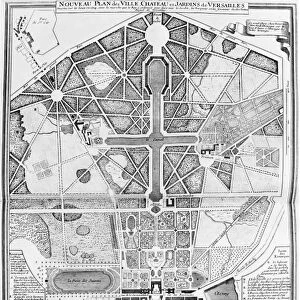
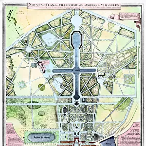
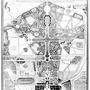
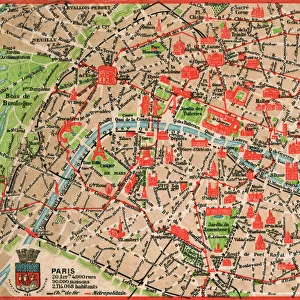
Jigsaw Puzzle : Map of Paris, from L Atlas de Paris by Jean de la Caille, 1714 (engraving)
")
")


![]()
Jigsaw Puzzles from Fine Art Finder
Map of Paris, from L Atlas de Paris by Jean de la Caille, 1714 (engraving)
781325 Map of Paris, from L Atlas de Paris by Jean de la Caille, 1714 (engraving) by French School, (18th century); Bibliotheque Historique de la Ville de Paris, Paris, France; (add.info.: Plan de Paris de la Caille ); French, out of copyright
Media ID 23164148
© Bridgeman Images
Birds Eye View Ile De La Cite Louvre River Seine Roads Ile St Louis
Jigsaw Puzzle (520 Pieces)
Discover the rich history and charm of Paris with our exquisite jigsaw puzzle from Media Storehouse. This intricately detailed puzzle features a captivating map of Paris, taken from L Atlas de Paris by Jean de la Caille, published in 1714. The engraving, by the French School, showcases the city's historic landmarks with stunning precision, transporting you back in time. Solve the puzzle pieces and bring the beautiful and iconic streets of Paris into your home, creating a unique and educational experience for all ages. Immerse yourself in the timeless allure of the City of Lights.
Made in the USA, 520-piece puzzles measure 16" x 20" (40.6 x 50.8 cm). Every puzzle is meticulously printed on glossy photo paper, which has a strong 1.33 mm thickness. Delivered in a black storage cardboard box, these puzzles are both stylish and practical. (Note: puzzles contain small parts and are not suitable for children under 3 years of age.)
Jigsaw Puzzles are an ideal gift for any occasion
Estimated Product Size is 50.8cm x 40.5cm (20" x 15.9")
These are individually made so all sizes are approximate
Artwork printed orientated as per the preview above, with landscape (horizontal) or portrait (vertical) orientation to match the source image.
FEATURES IN THESE COLLECTIONS
> Fine Art Finder
> Artists
> French School
> Fine Art Finder
> Paris & Versailles
> Europe
> France
> Paris
> Maps
> Europe
> France
> Paris
> Museums
> The Louvre
> Europe
> France
> Paris
> River Seine
> Europe
> France
> Paris
> Sights
> Louvre
> Maps and Charts
> Early Maps
> Maps and Charts
> Related Images
EDITORS COMMENTS
This print showcases a remarkable piece of history - the Map of Paris from L Atlas de Paris by Jean de la Caille, engraved in 1714. Created by the French School in the 18th century, this map is now housed at the Bibliotheque Historique de la Ville de Paris in France. The intricately detailed engraving takes us back to a time when Paris was still evolving and expanding. It offers a fascinating glimpse into the city's layout during that era, highlighting its iconic landmarks such as the Louvre Palace and various historical buildings. The streets and roads depicted on this map provide insight into how people navigated through the bustling city centuries ago. From a bird's eye view perspective, we can trace the path of River Seine as it winds its way through Paris, dividing it into two islands - Ile de la Cité and Ile St Louis. This map not only serves as an invaluable historical document but also captures the essence of French culture and architecture prevalent during that period. As we explore this exquisite print, we are transported to 18th-century Paris, immersing ourselves in its charm and grandeur. It reminds us of how cities evolve over time while preserving their unique heritage. A true treasure for history enthusiasts and lovers of fine art alike!
MADE IN THE USA
Safe Shipping with 30 Day Money Back Guarantee
FREE PERSONALISATION*
We are proud to offer a range of customisation features including Personalised Captions, Color Filters and Picture Zoom Tools
SECURE PAYMENTS
We happily accept a wide range of payment options so you can pay for the things you need in the way that is most convenient for you
* Options may vary by product and licensing agreement. Zoomed Pictures can be adjusted in the Cart.