Jigsaw Puzzle > Arts > Artists > G > Giovanni Xenodocus da Corfu
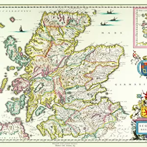
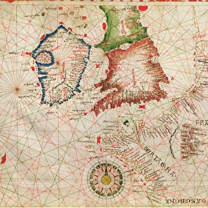
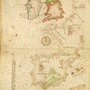
Jigsaw Puzzle : The French Coast, England, Scotland and Ireland, from a nautical atlas, 1520 (ink on vellum)
")
")


![]()
Jigsaw Puzzles from Fine Art Finder
The French Coast, England, Scotland and Ireland, from a nautical atlas, 1520 (ink on vellum)
XOT330911 The French Coast, England, Scotland and Ireland, from a nautical atlas, 1520 (ink on vellum) (detail from 330910) by Giovanni Xenodocus da Corfu (fl. 16th Century); Museo Correr, Venice, Italy; Greek, out of copyright
Media ID 12852561
© www.bridgemanart.com
Chart Compass Mapping Portolan
Jigsaw Puzzle (520 Pieces)
Discover the rich history of cartography with our exquisite jigsaw puzzles from Media Storehouse, featuring the intricate and captivating image "The French Coast, England, Scotland and Ireland, from a nautical atlas, 1520 (ink on vellum)" by Giovanni Xenodocus da Corfu. This stunning artwork, sourced from Bridgeman Art Library through Fine Art Finder, transports you back in time as you piece together the detailed coastlines of France, England, Scotland, and Ireland as they appeared over 500 years ago. Immerse yourself in the intricacies of this historical puzzle and explore the world from a new perspective. Perfect for history enthusiasts and puzzle lovers alike.
Made in the USA, 520-piece puzzles measure 16" x 20" (40.6 x 50.8 cm). Every puzzle is meticulously printed on glossy photo paper, which has a strong 1.33 mm thickness. Delivered in a black storage cardboard box, these puzzles are both stylish and practical. (Note: puzzles contain small parts and are not suitable for children under 3 years of age.)
Jigsaw Puzzles are an ideal gift for any occasion
Estimated Product Size is 50.8cm x 40.5cm (20" x 15.9")
These are individually made so all sizes are approximate
Artwork printed orientated as per the preview above, with landscape (horizontal) or portrait (vertical) orientation to match the source image.
FEATURES IN THESE COLLECTIONS
> Fine Art Finder
> Artists
> G
> Giovanni Xenodocus da Corfu Giovanni
> Fine Art Finder
> Artists
> Giovanni Xenodocus da Corfu
> Fine Art Finder
> Maps (celestial & Terrestrial)
> Arts
> Artists
> G
> Giovanni Xenodocus da Corfu
> Europe
> Greece
> Related Images
> Europe
> Italy
> Veneto
> Venice
> Europe
> Republic of Ireland
> Maps
> Europe
> United Kingdom
> England
> Maps
> Europe
> United Kingdom
> Scotland
> Maps
EDITORS COMMENTS
This print takes us back in time to the 16th century, showcasing a detailed nautical atlas created by Giovanni Xenodocus da Corfu. The ink on vellum masterpiece depicts "The French Coast, England, Scotland and Ireland" offering a glimpse into the intricate world of cartography during this era. As we examine this exquisite detail from the larger artwork, our eyes are immediately drawn to the precision with which each coastline is depicted. The delicate lines and careful shading bring forth an air of authenticity that transports us to these distant lands. The artist's mastery is evident in his skillful use of portolan charts and compasses, which were essential tools for navigators at that time. Through their meticulous application, da Corfu has successfully captured not only the geographical features but also the spirit of exploration prevalent during this period. Displayed within Museo Correr in Venice, Italy, this piece serves as a testament to both artistic talent and historical significance. It reminds us of the invaluable role that maps played in shaping our understanding of the world centuries ago. Intriguingly timeless yet firmly rooted in its historical context, this photograph invites viewers to appreciate not only its aesthetic beauty but also its contribution to our collective knowledge about geography and navigation throughout history.
MADE IN THE USA
Safe Shipping with 30 Day Money Back Guarantee
FREE PERSONALISATION*
We are proud to offer a range of customisation features including Personalised Captions, Color Filters and Picture Zoom Tools
SECURE PAYMENTS
We happily accept a wide range of payment options so you can pay for the things you need in the way that is most convenient for you
* Options may vary by product and licensing agreement. Zoomed Pictures can be adjusted in the Cart.