Metal Print > Arts > Artists > G > Giovanni Xenodocus da Corfu
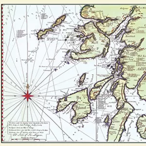
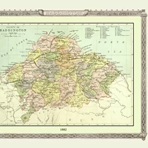
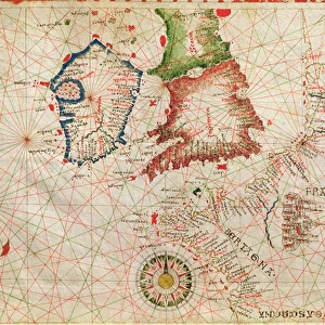
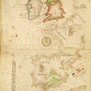
Metal Print : The French Coast, England, Scotland and Ireland, from a nautical atlas, 1520 (ink on vellum)
")


![]()
Metal Prints from Fine Art Finder
The French Coast, England, Scotland and Ireland, from a nautical atlas, 1520 (ink on vellum)
XOT330911 The French Coast, England, Scotland and Ireland, from a nautical atlas, 1520 (ink on vellum) (detail from 330910) by Giovanni Xenodocus da Corfu (fl. 16th Century); Museo Correr, Venice, Italy; Greek, out of copyright
Media ID 12852561
© www.bridgemanart.com
Chart Compass Mapping Portolan
16"x20" (51x41cm) Metal Print
Transport yourself back in time with our exquisite Media Storehouse Metal Prints featuring the intricately detailed nautical chart, "The French Coast, England, Scotland and Ireland, from a nautical atlas, 1520 (ink on vellum)" by Giovanni Xenodocus da Corfu. This captivating artwork, sourced from Bridgeman Art Library through Fine Art Finder, offers a glimpse into the past with its intricate lines and precise cartography. The metal print's vibrant colors and high-definition clarity bring out the rich textures and details of this historical masterpiece, making it a stunning addition to any home or office decor. Immerse yourself in the history of cartography and add a touch of timeless beauty to your space with this unique and captivating Metal Print.
Made with durable metal and luxurious printing techniques, our metal photo prints go beyond traditional canvases, adding a cool, modern touch to your space. Wall mount on back. Eco-friendly 100% post-consumer recycled ChromaLuxe aluminum surface. The thickness of the print is 0.045". Featuring a Scratch-resistant surface and Rounded corners. Backing hangers are attached to the back of the print and float the print 1/2-inch off the wall when hung, the choice of hanger may vary depending on size and International orders will come with Float Mount hangers only. Finished with a brilliant white high gloss surface for unsurpassed detail and vibrance. Printed using Dye-Sublimation and for best care we recommend a non-ammonia glass cleaner, water, or isopropyl (rubbing) alcohol to prevent harming the print surface. We recommend using a clean, lint-free cloth to wipe off the print. The ultra-hard surface is scratch-resistant, waterproof and weatherproof. Avoid direct sunlight exposure.
Made with durable metal and luxurious printing techniques, metal prints bring images to life and add a modern touch to any space
Estimated Image Size (if not cropped) is 50.8cm x 40.6cm (20" x 16")
Estimated Product Size is 51.4cm x 41.2cm (20.2" x 16.2")
These are individually made so all sizes are approximate
Artwork printed orientated as per the preview above, with landscape (horizontal) orientation to match the source image.
FEATURES IN THESE COLLECTIONS
> Fine Art Finder
> Artists
> G
> Giovanni Xenodocus da Corfu Giovanni
> Fine Art Finder
> Artists
> Giovanni Xenodocus da Corfu
> Fine Art Finder
> Maps (celestial & Terrestrial)
> Arts
> Artists
> G
> Giovanni Xenodocus da Corfu
> Europe
> Greece
> Related Images
> Europe
> Italy
> Veneto
> Venice
> Europe
> Republic of Ireland
> Maps
> Europe
> United Kingdom
> England
> Maps
> Europe
> United Kingdom
> Scotland
> Maps
EDITORS COMMENTS
This print takes us back in time to the 16th century, showcasing a detailed nautical atlas created by Giovanni Xenodocus da Corfu. The ink on vellum masterpiece depicts "The French Coast, England, Scotland and Ireland" offering a glimpse into the intricate world of cartography during this era. As we examine this exquisite detail from the larger artwork, our eyes are immediately drawn to the precision with which each coastline is depicted. The delicate lines and careful shading bring forth an air of authenticity that transports us to these distant lands. The artist's mastery is evident in his skillful use of portolan charts and compasses, which were essential tools for navigators at that time. Through their meticulous application, da Corfu has successfully captured not only the geographical features but also the spirit of exploration prevalent during this period. Displayed within Museo Correr in Venice, Italy, this piece serves as a testament to both artistic talent and historical significance. It reminds us of the invaluable role that maps played in shaping our understanding of the world centuries ago. Intriguingly timeless yet firmly rooted in its historical context, this photograph invites viewers to appreciate not only its aesthetic beauty but also its contribution to our collective knowledge about geography and navigation throughout history.
MADE IN THE USA
Safe Shipping with 30 Day Money Back Guarantee
FREE PERSONALISATION*
We are proud to offer a range of customisation features including Personalised Captions, Color Filters and Picture Zoom Tools
SECURE PAYMENTS
We happily accept a wide range of payment options so you can pay for the things you need in the way that is most convenient for you
* Options may vary by product and licensing agreement. Zoomed Pictures can be adjusted in the Cart.