Jigsaw Puzzle > Europe > United Kingdom > England > Norfolk > Norwich
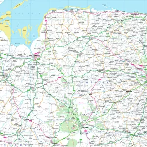
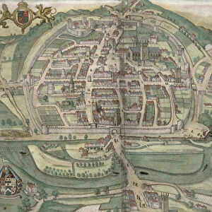
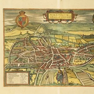
Jigsaw Puzzle : Map of Norwich, Norfolk (engraving)
")
")


![]()
Jigsaw Puzzles from Fine Art Finder
Map of Norwich, Norfolk (engraving)
5233675 Map of Norwich, Norfolk (engraving) by English School, (16th century) (after); Private Collection; (add.info.: Map of Norwich, Norfolk.); Look and Learn / Elgar Collection
Media ID 22567450
© Look and Learn / Elgar Collection / Bridgeman Images
House Of Tudor Norfolk Norwich Tudor Dynasty Tudor Period Tudor Times Tudors Dynasty
Jigsaw Puzzle (520 Pieces)
Discover the rich history of Norwich, Norfolk with our exquisite jigsaw puzzle from Media Storehouse. Featuring a stunning engraving of a Map of Norwich, Norfolk by Bridgeman Images from Fine Art Finder, this puzzle brings the past to life. Dating back to the 16th century, this intricately detailed map showcases the layout of Norwich during an era of great significance. Ideal for puzzle enthusiasts and history buffs alike, this challenging yet rewarding puzzle is a must-have addition to any collection. Immerse yourself in the beauty and history of Norwich with our Media Storehouse jigsaw puzzle.
Made in the USA, 520-piece puzzles measure 16" x 20" (40.6 x 50.8 cm). Every puzzle is meticulously printed on glossy photo paper, which has a strong 1.33 mm thickness. Delivered in a black storage cardboard box, these puzzles are both stylish and practical. (Note: puzzles contain small parts and are not suitable for children under 3 years of age.)
Jigsaw Puzzles are an ideal gift for any occasion
Estimated Product Size is 50.8cm x 40.5cm (20" x 15.9")
These are individually made so all sizes are approximate
Artwork printed orientated as per the preview above, with landscape (horizontal) or portrait (vertical) orientation to match the source image.
FEATURES IN THESE COLLECTIONS
> Fine Art Finder
> Artists
> George J. Stodart
> Fine Art Finder
> Schools
> English School
> Europe
> United Kingdom
> England
> Maps
> Europe
> United Kingdom
> England
> Norfolk
> Norwich
> Europe
> United Kingdom
> England
> Norfolk
> Related Images
> Europe
> United Kingdom
> England
> Norwich
> Europe
> United Kingdom
> Maps
> Maps and Charts
> Early Maps
> Maps and Charts
> Related Images
EDITORS COMMENTS
This print showcases a remarkable engraving of the Map of Norwich, Norfolk, created by an anonymous English artist in the 16th century. The intricate details and exquisite craftsmanship of this map offer a glimpse into the city's geography during the Tudor period. The Map of Norwich, Norfolk is a testament to the rich history and cultural heritage that defines this ancient British city. It provides a fascinating insight into how Norwich was positioned within Europe at that time, with its close proximity to France evident on the map. As we delve into this piece of cartography, we are transported back in time to explore the bustling streets and architectural wonders that once graced Norwich. The House of Tudor's influence can be seen throughout the map, reminding us of their significant reign over England during this era. This print not only serves as a visual delight but also offers an opportunity for historical exploration. It allows us to appreciate both British and European culture while highlighting Norwich's importance within these contexts. Displayed proudly in private collections around the world, this Fine Art Finder print captures an extraordinary moment in history. Its presence reminds us of our connection to past generations and invites us to celebrate our shared heritage as Britons within today's global community.
MADE IN THE USA
Safe Shipping with 30 Day Money Back Guarantee
FREE PERSONALISATION*
We are proud to offer a range of customisation features including Personalised Captions, Color Filters and Picture Zoom Tools
SECURE PAYMENTS
We happily accept a wide range of payment options so you can pay for the things you need in the way that is most convenient for you
* Options may vary by product and licensing agreement. Zoomed Pictures can be adjusted in the Cart.