Jigsaw Puzzle > Europe > Spain > Related Images
Jigsaw Puzzle : Trading map of the West Indies, 1707 (hand coloured print)
")
")


![]()
Jigsaw Puzzles from Fine Art Finder
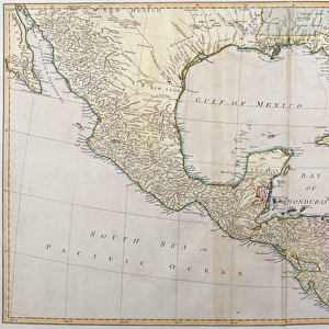
Trading map of the West Indies, 1707 (hand coloured print)
XOS1765725 Trading map of the West Indies, 1707 (hand coloured print) by English School, (18th century); New York Public Library, USA; (add.info.: A new and correct large draught of the tradeing part of the West Indies from a sea-atlas containing an hydrographical description of most of the sea-coasts of the known parts of the world by Samuel Thornton.); English, out of copyright
Media ID 12742641
© www.bridgemanimages.com
Atlantic Ocean Atlas Caribbean Caribbean Sea Central America Gulf Of Mexico Hydrography Islands Latitude Longitude Navigation New Spain North Sea Pilot Sea Chart Shipping Terrestrial Tropic Of Cancer
Jigsaw Puzzle (1014 Pieces)
Discover the rich history of the West Indies with our captivating jigsaw puzzle from Media Storehouse. Featuring a hand-colored print of a trading map from 1707, this intricately detailed puzzle brings the intrigue of the 18th century to your home. With the vibrant colors and intricate lines of this map from the New York Public Library, this puzzle is perfect for history buffs, puzzle enthusiasts, or anyone seeking an engaging and educational activity. Immerse yourself in the past as you piece together this beautiful and fascinating puzzle from Bridgeman Images.
Made in the USA, 1014-piece puzzles measure 20" x 30" (50.8 x 76.2 cm). Every puzzle is meticulously printed on glossy photo paper, which has a strong 1.33 mm thickness. Delivered in a black storage cardboard box, these puzzles are both stylish and practical. (Note: puzzles contain small parts and are not suitable for children under 3 years of age.)
Jigsaw Puzzles are an ideal gift for any occasion
Estimated Product Size is 76cm x 50.8cm (29.9" x 20")
These are individually made so all sizes are approximate
Artwork printed orientated as per the preview above, with landscape (horizontal) orientation to match the source image.
FEATURES IN THESE COLLECTIONS
> Fine Art Finder
> Maps (celestial & Terrestrial)
> Fine Art Finder
> Schools
> English School
> Europe
> Spain
> Related Images
> North America
> Related Images
> North America
> United States of America
> New York
> Related Images
> South America
> Related Images
EDITORS COMMENTS
This hand-coloured print, titled "Trading map of the West Indies, 1707" offers a captivating glimpse into the world of navigation and cartography in the 18th century. Created by an English School artist, this meticulously detailed map showcases the vast expanse of the West Indies region, stretching from Central America to South America. The map is part of Samuel Thornton's sea-atlas, which provides hydrographical descriptions of various coastlines around the world. It serves as a valuable resource for sailors and traders seeking accurate information about sea routes and trade opportunities. With its vibrant colors and intricate illustrations, this print invites viewers to explore not only the islands of the Caribbean but also adjacent bodies of water such as the Gulf of Mexico and Bay of Mexico. The presence of major landmarks like North America and South America further emphasizes the significance of these trading routes during that era. As we delve into this historical artifact, we gain insight into early maritime exploration efforts. This map played a crucial role in guiding ships through treacherous waters while facilitating international trade across continents. Its inclusion in New York Public Library's collection highlights its enduring value as both a work of art and an important piece in our understanding of global history.
MADE IN THE USA
Safe Shipping with 30 Day Money Back Guarantee
FREE PERSONALISATION*
We are proud to offer a range of customisation features including Personalised Captions, Color Filters and Picture Zoom Tools
SECURE PAYMENTS
We happily accept a wide range of payment options so you can pay for the things you need in the way that is most convenient for you
* Options may vary by product and licensing agreement. Zoomed Pictures can be adjusted in the Cart.