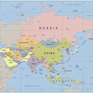
Jigsaw Puzzle > North America > United States of America > New York > New York > Maps
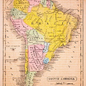
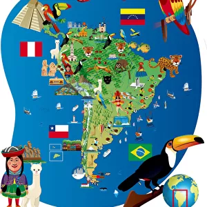
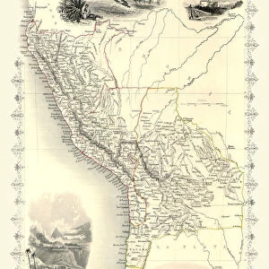
Jigsaw Puzzle : Map of South America 1895


![]()
Jigsaw Puzzles from Fine Art Storehouse
Map of South America 1895
The Rand-McNally Grammar School Geography 1895 - Chicago & New York
Unleash your creativity and transform your space into a visual masterpiece!
THEPALMER
Media ID 14824647
© This content is subject to copyright
Argentine Bolivia Brazil Chile Colombia Ecuador Paraguay Peru South America Venezuela
Jigsaw Puzzle (520 Pieces)
Discover the rich history of geography with our captivating jigsaw puzzle from Media Storehouse - Map of South America 1895 by THEPALMER from Fine Art Storehouse. This intricately detailed puzzle, featuring an authentic reproduction of the Rand-McNally Grammar School Geography map published in 1895 in both Chicago and New York, offers a fun and educational experience for all ages. Immerse yourself in the exploration of South America's diverse landscapes, cultures, and landmarks as you piece together this beautiful puzzle. Perfect for expanding knowledge, stimulating the mind, and creating cherished memories with family and friends.
Made in the USA, 520-piece puzzles measure 16" x 20" (40.6 x 50.8 cm). Every puzzle is meticulously printed on glossy photo paper, which has a strong 1.33 mm thickness. Delivered in a black storage cardboard box, these puzzles are both stylish and practical. (Note: puzzles contain small parts and are not suitable for children under 3 years of age.)
Jigsaw Puzzles are an ideal gift for any occasion
Estimated Product Size is 40.5cm x 50.8cm (15.9" x 20")
These are individually made so all sizes are approximate
Artwork printed orientated as per the preview above, with landscape (horizontal) or portrait (vertical) orientation to match the source image.
FEATURES IN THESE COLLECTIONS
> Fine Art Storehouse
> Map
> Historical Maps
> Arts
> Artists
> P
> Peruvian School Peruvian School
> Maps and Charts
> Related Images
> North America
> United States of America
> New York
> New York
> Maps
> North America
> United States of America
> New York
> Related Images
> South America
> Argentina
> Maps
> South America
> Argentina
> Related Images
> South America
> Bolivia
> Maps
> South America
> Bolivia
> Related Images
> South America
> Brazil
> Maps
EDITORS COMMENTS
This print titled "Map of South America 1895" takes us on a journey back in time to the late 19th century. The map, originally featured in "The Rand-McNally Grammar School Geography 1895" is a testament to the meticulous craftsmanship and attention to detail that went into cartography during this era. As we gaze upon this vintage piece, our eyes are immediately drawn to the intricate lines and vibrant colors that bring each country of South America to life. From Chile's elongated shape stretching along the western coast, through Peru's diverse landscapes, Argentina's vast plains, Bolivia's high-altitude beauty, Brazil's expansive rainforests, Colombia's lush greenery, Ecuador's equatorial charm, Paraguay's landlocked serenity all the way up north to Venezuela – every nation is meticulously outlined with precision. The map not only serves as a visual representation of geographical boundaries but also provides valuable insights into historical context. It reminds us of an era when exploration and discovery were at their peak; when adventurers set sail across uncharted waters in search of new lands and treasures. "The Map of South America 1895" by THEPALMER captures both our imagination and curiosity about this fascinating continent. It invites us to delve deeper into its rich history while appreciating the artistry behind such detailed cartographic works. This print is truly a timeless piece that would make an excellent addition for any history enthusiast or lover of vintage aesthetics alike.
MADE IN THE USA
Safe Shipping with 30 Day Money Back Guarantee
FREE PERSONALISATION*
We are proud to offer a range of customisation features including Personalised Captions, Color Filters and Picture Zoom Tools
SECURE PAYMENTS
We happily accept a wide range of payment options so you can pay for the things you need in the way that is most convenient for you
* Options may vary by product and licensing agreement. Zoomed Pictures can be adjusted in the Cart.