Fine Art Print > North America > United States of America > New York > New York > Maps
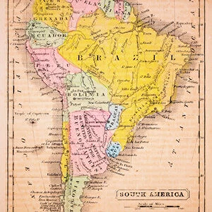
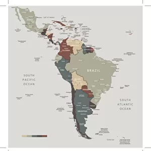
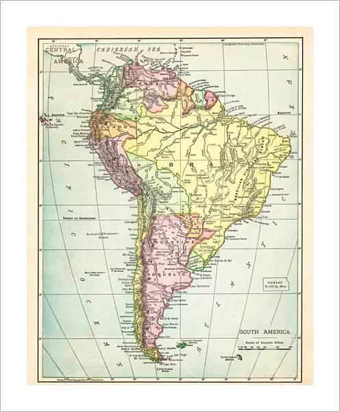
Fine Art Print : Map of South America 1895


![]()
Fine Art Prints from Fine Art Storehouse
Map of South America 1895
The Rand-McNally Grammar School Geography 1895 - Chicago & New York
Unleash your creativity and transform your space into a visual masterpiece!
THEPALMER
Media ID 14824647
© This content is subject to copyright
Argentine Bolivia Brazil Chile Colombia Ecuador Paraguay Peru South America Venezuela
20"x16" (+3" Border) Fine Art Print
Discover the rich history of cartography with our exquisite Fine Art Print of "Map of South America 1895" by THEPALMER from the Fine Art Storehouse collection. This captivating piece is a vintage reproduction of the Rand-McNally Grammar School Geography map published in Chicago and New York in 1895. Add an air of sophistication and historical intrigue to your home or office decor with this stunning, museum-quality print. Each print is meticulously crafted using archival-quality materials, ensuring your investment is a long-lasting treasure. Transport yourself back in time and explore the world's geography through the lens of the past. Order now and bring a piece of history into your space.
20x16 image printed on 26x22 Fine Art Rag Paper with 3" (76mm) white border. Our Fine Art Prints are printed on 300gsm 100% acid free, PH neutral paper with archival properties. This printing method is used by museums and art collections to exhibit photographs and art reproductions.
Our fine art prints are high-quality prints made using a paper called Photo Rag. This 100% cotton rag fibre paper is known for its exceptional image sharpness, rich colors, and high level of detail, making it a popular choice for professional photographers and artists. Photo rag paper is our clear recommendation for a fine art paper print. If you can afford to spend more on a higher quality paper, then Photo Rag is our clear recommendation for a fine art paper print.
Estimated Image Size (if not cropped) is 40.6cm x 50.8cm (16" x 20")
Estimated Product Size is 55.9cm x 66cm (22" x 26")
These are individually made so all sizes are approximate
Artwork printed orientated as per the preview above, with portrait (vertical) orientation to match the source image.
FEATURES IN THESE COLLECTIONS
> Arts
> Artists
> P
> Peruvian School Peruvian School
> Maps and Charts
> Related Images
> North America
> United States of America
> New York
> New York
> Maps
> North America
> United States of America
> New York
> Related Images
> South America
> Argentina
> Maps
> South America
> Argentina
> Related Images
> South America
> Bolivia
> Maps
> South America
> Bolivia
> Related Images
> South America
> Brazil
> Maps
> Fine Art Storehouse
> Map
> Historical Maps
EDITORS COMMENTS
This print titled "Map of South America 1895" takes us on a journey back in time to the late 19th century. The map, originally featured in "The Rand-McNally Grammar School Geography 1895" is a testament to the meticulous craftsmanship and attention to detail that went into cartography during this era. As we gaze upon this vintage piece, our eyes are immediately drawn to the intricate lines and vibrant colors that bring each country of South America to life. From Chile's elongated shape stretching along the western coast, through Peru's diverse landscapes, Argentina's vast plains, Bolivia's high-altitude beauty, Brazil's expansive rainforests, Colombia's lush greenery, Ecuador's equatorial charm, Paraguay's landlocked serenity all the way up north to Venezuela – every nation is meticulously outlined with precision. The map not only serves as a visual representation of geographical boundaries but also provides valuable insights into historical context. It reminds us of an era when exploration and discovery were at their peak; when adventurers set sail across uncharted waters in search of new lands and treasures. "The Map of South America 1895" by THEPALMER captures both our imagination and curiosity about this fascinating continent. It invites us to delve deeper into its rich history while appreciating the artistry behind such detailed cartographic works. This print is truly a timeless piece that would make an excellent addition for any history enthusiast or lover of vintage aesthetics alike.
MADE IN THE USA
Safe Shipping with 30 Day Money Back Guarantee
FREE PERSONALISATION*
We are proud to offer a range of customisation features including Personalised Captions, Color Filters and Picture Zoom Tools
SECURE PAYMENTS
We happily accept a wide range of payment options so you can pay for the things you need in the way that is most convenient for you
* Options may vary by product and licensing agreement. Zoomed Pictures can be adjusted in the Cart.