Jigsaw Puzzle > Arts > Still life artwork > Watercolor paintings > Fine art
Jigsaw Puzzle : Illustrated map of ancient Assyrian empire


![]()
Jigsaw Puzzles from Fine Art Storehouse
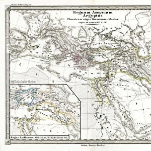
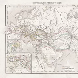
Illustrated map of ancient Assyrian empire
Unleash your creativity and transform your space into a visual masterpiece!
Dorling Kindersley
Media ID 13540807
© This content is subject to copyright
Ancient Civilisations Ancient History Assyria Background People Empire Geography Illustrated Map Incidental People Middle East Watercolour Painting
Jigsaw Puzzle (520 Pieces)
Discover the rich history of the ancient Assyrian empire with our stunning jigsaw puzzle from the Media Storehouse collection, exclusively published by Dorling Kindersley through Fine Art Storehouse. This intricately illustrated map invites you on a captivating journey through time, as you piece together the intricate details of this once powerful civilization. With vibrant colors and meticulous attention to detail, this puzzle is not only a fun and engaging activity, but also a beautiful addition to any home or office. Immerse yourself in the fascinating world of ancient Assyria, and let the puzzle-solving adventure begin!
Made in the USA, 520-piece puzzles measure 16" x 20" (40.6 x 50.8 cm). Every puzzle is meticulously printed on glossy photo paper, which has a strong 1.33 mm thickness. Delivered in a black storage cardboard box, these puzzles are both stylish and practical. (Note: puzzles contain small parts and are not suitable for children under 3 years of age.)
Jigsaw Puzzles are an ideal gift for any occasion
Estimated Product Size is 50.8cm x 40.5cm (20" x 15.9")
These are individually made so all sizes are approximate
Artwork printed orientated as per the preview above, with landscape (horizontal) or portrait (vertical) orientation to match the source image.
FEATURES IN THESE COLLECTIONS
> Fine Art Storehouse
> Photo Libraries
> Dorling Kindersley Prints
> Arts
> Still life artwork
> Watercolor paintings
> Fine art
> Arts
> Watercolor paintings
> Watercolor illustrations
> Historic
> Ancient civilizations
> Maps and Charts
> Early Maps
> Maps and Charts
> Related Images
EDITORS COMMENTS
This print showcases an exquisite "Illustrated map of the ancient Assyrian empire" created by renowned artist Dorling Kindersley. Steeped in rich history and cultural significance, this artwork takes us on a mesmerizing journey back to one of the most powerful civilizations that once thrived in the Middle East. The map, rendered with delicate watercolor strokes, beautifully captures the vastness and complexity of the ancient Assyrian empire. With its horizontal layout against a pristine white background, every detail comes to life - from sprawling cities to majestic rivers and mountains that shaped their physical geography. As we delve into this masterpiece, our eyes are drawn not only to the grandeur of this mighty empire but also to the incidental people depicted throughout. These background figures add depth and context, reminding us that behind every great civilization lies a tapestry woven by countless individuals. Through vibrant colors and meticulous attention to historical accuracy, Dorling Kindersley transports us effortlessly into a forgotten era where empires rose and fell. This illustration serves as both an educational tool for those fascinated by ancient civilizations and a stunning piece of art for any enthusiast's collection. With its impeccable composition and evocative style, this studio-shot print is sure to captivate viewers who seek glimpses into humanity's past. Let it transport you back in time as you explore the wonders of ancient Assyria through Dorling Kindersley's masterful brushstrokes.
MADE IN THE USA
Safe Shipping with 30 Day Money Back Guarantee
FREE PERSONALISATION*
We are proud to offer a range of customisation features including Personalised Captions, Color Filters and Picture Zoom Tools
SECURE PAYMENTS
We happily accept a wide range of payment options so you can pay for the things you need in the way that is most convenient for you
* Options may vary by product and licensing agreement. Zoomed Pictures can be adjusted in the Cart.