Jigsaw Puzzle > Historic > Ancient civilizations > Mesopotamia > Ancient Mesopotamian art
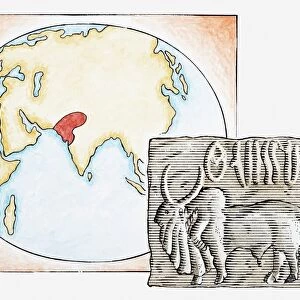
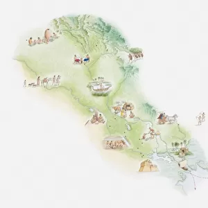
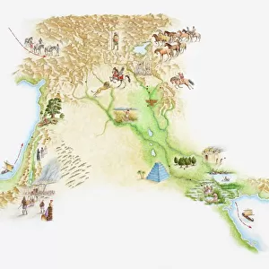
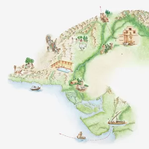
Jigsaw Puzzle : Illustrated map of Indus Valley civilisation


![]()
Jigsaw Puzzles from Fine Art Storehouse
Illustrated map of Indus Valley civilisation
Unleash your creativity and transform your space into a visual masterpiece!
Dorling Kindersley
Media ID 13540799
© This content is subject to copyright
Ancient Civilisations Ancient History Background People Empire Geography Illustrated Map Incidental People Mesopotamia Mesopotamian Indus Valley Watercolour Painting
Jigsaw Puzzle (520 Pieces)
Discover the rich history of the Indus Valley civilization with our stunning jigsaw puzzle from Media Storehouse, in partnership with Dorling Kindersley's Fine Art Storehouse. This intricately illustrated map brings the ancient world to life, allowing you to piece together the mysteries of one of history's most fascinating civilizations. Immerse yourself in the intricate details and vibrant colors as you explore the Indus Valley, uncovering the secrets of its cities, temples, and people. A perfect addition to any home or classroom, this jigsaw puzzle is a fun and engaging way to learn about history and expand your knowledge. Engage your mind, challenge your problem-solving skills, and transport yourself to another time and place with Media Storehouse's Indus Valley Civilization jigsaw puzzle.
Made in the USA, 520-piece puzzles measure 16" x 20" (40.6 x 50.8 cm). Every puzzle is meticulously printed on glossy photo paper, which has a strong 1.33 mm thickness. Delivered in a black storage cardboard box, these puzzles are both stylish and practical. (Note: puzzles contain small parts and are not suitable for children under 3 years of age.)
Jigsaw Puzzles are an ideal gift for any occasion
Estimated Product Size is 50.8cm x 40.5cm (20" x 15.9")
These are individually made so all sizes are approximate
Artwork printed orientated as per the preview above, with landscape (horizontal) or portrait (vertical) orientation to match the source image.
FEATURES IN THESE COLLECTIONS
> Fine Art Storehouse
> Photo Libraries
> Dorling Kindersley Prints
> Arts
> Still life artwork
> Watercolor paintings
> Fine art
> Arts
> Watercolor paintings
> Watercolor illustrations
> Historic
> Ancient civilizations
> Indus Valley Civilization
> Historic
> Ancient civilizations
> Mesopotamia
> Ancient Mesopotamian art
> Historic
> Ancient civilizations
> Mesopotamia
> Historic
> Ancient civilizations
> Maps and Charts
> Early Maps
> Maps and Charts
> Related Images
EDITORS COMMENTS
This print showcases an exquisite "Illustrated map of Indus Valley civilization" by Dorling Kindersley. Steeped in ancient history, this horizontal watercolor painting takes us on a mesmerizing journey through time. The artist's meticulous attention to detail brings the Indus Valley civilization to life, capturing its grandeur and significance. The map transports us back to a bygone era, where bustling cities and thriving communities once flourished along the banks of the mighty Indus River. Mesmerizing shades of blue depict the flowing waters that were integral to sustaining this remarkable empire. As we explore this masterpiece, we are introduced to various elements that defined the civilization's identity. From intricate illustrations of architectural marvels like Mohenjo-daro and Harappa, to depictions of daily life activities such as farming and trading - every corner tells a story. Against a pristine white background, vibrant colors effortlessly blend together creating an atmosphere filled with intrigue and wonder. This studio shot captures every brushstroke with precision, allowing us to appreciate the artistry behind each stroke. With incidental people scattered throughout the composition, we gain perspective on how vast this ancient empire truly was. It serves as a reminder of our connection to those who came before us and their contributions in shaping our world today. This illustrated map is not just a visual delight but also serves as an educational tool for enthusiasts seeking knowledge about ancient civilizations or physical geography. It encapsulates centuries-old mysteries within its frame while igniting curiosity for further exploration into
MADE IN THE USA
Safe Shipping with 30 Day Money Back Guarantee
FREE PERSONALISATION*
We are proud to offer a range of customisation features including Personalised Captions, Color Filters and Picture Zoom Tools
SECURE PAYMENTS
We happily accept a wide range of payment options so you can pay for the things you need in the way that is most convenient for you
* Options may vary by product and licensing agreement. Zoomed Pictures can be adjusted in the Cart.