Jigsaw Puzzle > Europe > United Kingdom > England > Maps
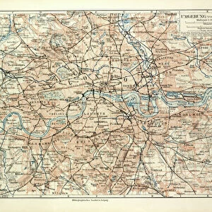
Jigsaw Puzzle : 1848, Crutchley Pocket Map or Plan of London, England, topography, cartography, geography


![]()
Jigsaw Puzzles from Liszt Collection
1848, Crutchley Pocket Map or Plan of London, England, topography, cartography, geography
1848, Crutchley Pocket Map or Plan of London, England
Liszt Collection of nineteenth-century engravings and images to browse and enjoy
Media ID 14005147
© Artokoloro Quint Lox Limited
1848 Antique Map Latitude Longitude Mappa Mundi Old Antique Plan Old Antique View Ols Antique Map Rare Old Maps Topo
Jigsaw Puzzle (520 Pieces)
Discover the charm of the past with our Media Storehouse Jigsaw Puzzle featuring the 1848 Crutchley Pocket Map or Plan of London. This intriguing puzzle brings to life the topography, cartography, and geography of London during a pivotal period in its history. Immerse yourself in the intricate details of this beautifully preserved map from the Liszt Collection. With every piece you place, uncover the stories and secrets hidden within this historical snapshot of London. Perfect for puzzle enthusiasts, history buffs, and anyone looking to add a touch of antiquity to their home or office.
Made in the USA, 520-piece puzzles measure 16" x 20" (40.6 x 50.8 cm). Every puzzle is meticulously printed on glossy photo paper, which has a strong 1.33 mm thickness. Delivered in a black storage cardboard box, these puzzles are both stylish and practical. (Note: puzzles contain small parts and are not suitable for children under 3 years of age.)
Jigsaw Puzzles are an ideal gift for any occasion
Estimated Product Size is 50.8cm x 40.5cm (20" x 15.9")
These are individually made so all sizes are approximate
Artwork printed orientated as per the preview above, with landscape (horizontal) or portrait (vertical) orientation to match the source image.
FEATURES IN THESE COLLECTIONS
> Europe
> France
> Canton
> Landes
> Europe
> United Kingdom
> England
> Maps
> Historic
> Space exploration
> Maps and Charts
> Early Maps
> Maps and Charts
> Related Images
> Maps and Charts
> World
EDITORS COMMENTS
This print showcases the remarkable "1848, Crutchley Pocket Map or Plan of London, England" a true gem in the realms of topography, cartography, and geography. With its intricate details and precise craftsmanship, this vintage map takes us on a journey back in time to explore the historic streets and landmarks of London during that era. The artist's skillful use of various artistic techniques brings this ancient map to life. The delicate lines and vibrant colors beautifully depict the city's landscape, allowing us to immerse ourselves in its rich history. As we gaze upon this decorative piece of art, we can't help but marvel at how it serves as both a navigational tool and a testament to human curiosity. Every corner of this old antique plan holds stories waiting to be discovered. It invites us to embark on an exploration through time as we trace our fingers along its gridlines and latitude/longitude markings. This rare artifact from another age reminds us that maps are not just tools for navigation but also windows into the past. Whether you're an avid collector or simply appreciate historical treasures, this stunning print is sure to captivate your imagination. Let it transport you back in time as you admire its aged beauty and ponder the journeys taken by those who relied on such maps centuries ago.
MADE IN THE USA
Safe Shipping with 30 Day Money Back Guarantee
FREE PERSONALISATION*
We are proud to offer a range of customisation features including Personalised Captions, Color Filters and Picture Zoom Tools
SECURE PAYMENTS
We happily accept a wide range of payment options so you can pay for the things you need in the way that is most convenient for you
* Options may vary by product and licensing agreement. Zoomed Pictures can be adjusted in the Cart.