Metal Print > Europe > United Kingdom > England > Maps
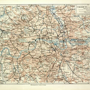
Metal Print : 1848, Crutchley Pocket Map or Plan of London, England, topography, cartography, geography


![]()
Metal Prints from Liszt Collection
1848, Crutchley Pocket Map or Plan of London, England, topography, cartography, geography
1848, Crutchley Pocket Map or Plan of London, England
Liszt Collection of nineteenth-century engravings and images to browse and enjoy
Media ID 14005147
© Artokoloro Quint Lox Limited
1848 Antique Map Latitude Longitude Mappa Mundi Old Antique Plan Old Antique View Ols Antique Map Rare Old Maps Topo
16"x20" (51x41cm) Metal Print
Discover history in a new light with our Media Storehouse Metal Prints featuring the iconic 1848 Crutchley Pocket Map or Plan of London. This exquisite piece of cartographic art showcases the topography and geography of London during a pivotal period in its history. The intricate details of the 1848 map, sourced from the esteemed Liszt Collection, are brought to life through our premium metal print process. Each print is meticulously crafted to preserve the authenticity of the original map, while the high-quality metal material adds a contemporary and stylish touch to your space. Elevate your home or office décor with this unique and captivating representation of London's rich history.
Made with durable metal and luxurious printing techniques, our metal photo prints go beyond traditional canvases, adding a cool, modern touch to your space. Wall mount on back. Eco-friendly 100% post-consumer recycled ChromaLuxe aluminum surface. The thickness of the print is 0.045". Featuring a Scratch-resistant surface and Rounded corners. Backing hangers are attached to the back of the print and float the print 1/2-inch off the wall when hung, the choice of hanger may vary depending on size and International orders will come with Float Mount hangers only. Finished with a brilliant white high gloss surface for unsurpassed detail and vibrance. Printed using Dye-Sublimation and for best care we recommend a non-ammonia glass cleaner, water, or isopropyl (rubbing) alcohol to prevent harming the print surface. We recommend using a clean, lint-free cloth to wipe off the print. The ultra-hard surface is scratch-resistant, waterproof and weatherproof. Avoid direct sunlight exposure.
Made with durable metal and luxurious printing techniques, metal prints bring images to life and add a modern touch to any space
Estimated Image Size (if not cropped) is 50.8cm x 40.6cm (20" x 16")
Estimated Product Size is 51.4cm x 41.2cm (20.2" x 16.2")
These are individually made so all sizes are approximate
Artwork printed orientated as per the preview above, with landscape (horizontal) orientation to match the source image.
FEATURES IN THESE COLLECTIONS
> Europe
> France
> Canton
> Landes
> Europe
> United Kingdom
> England
> Maps
> Historic
> Space exploration
> Maps and Charts
> Early Maps
> Maps and Charts
> Related Images
> Maps and Charts
> World
EDITORS COMMENTS
This print showcases the remarkable "1848, Crutchley Pocket Map or Plan of London, England" a true gem in the realms of topography, cartography, and geography. With its intricate details and precise craftsmanship, this vintage map takes us on a journey back in time to explore the historic streets and landmarks of London during that era. The artist's skillful use of various artistic techniques brings this ancient map to life. The delicate lines and vibrant colors beautifully depict the city's landscape, allowing us to immerse ourselves in its rich history. As we gaze upon this decorative piece of art, we can't help but marvel at how it serves as both a navigational tool and a testament to human curiosity. Every corner of this old antique plan holds stories waiting to be discovered. It invites us to embark on an exploration through time as we trace our fingers along its gridlines and latitude/longitude markings. This rare artifact from another age reminds us that maps are not just tools for navigation but also windows into the past. Whether you're an avid collector or simply appreciate historical treasures, this stunning print is sure to captivate your imagination. Let it transport you back in time as you admire its aged beauty and ponder the journeys taken by those who relied on such maps centuries ago.
MADE IN THE USA
Safe Shipping with 30 Day Money Back Guarantee
FREE PERSONALISATION*
We are proud to offer a range of customisation features including Personalised Captions, Color Filters and Picture Zoom Tools
SECURE PAYMENTS
We happily accept a wide range of payment options so you can pay for the things you need in the way that is most convenient for you
* Options may vary by product and licensing agreement. Zoomed Pictures can be adjusted in the Cart.