Jigsaw Puzzle > Arts > Landscape paintings > Waterfall and river artworks > River artworks
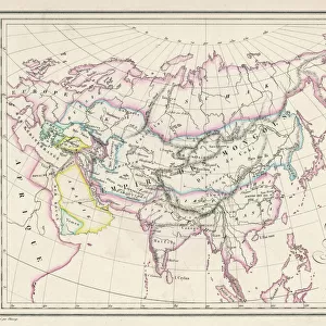
Jigsaw Puzzle : Map of ancient Egypt


![]()
Jigsaw Puzzles from North Wind
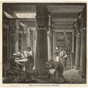
Map of ancient Egypt
Map of ancient Egypt.
Printed color lithograph
North Wind Picture Archives brings history to life with stock images and hand-colored illustrations
Media ID 5878047
© North Wind Picture Archives
Africa Alexandria Ancient Ancient Egypt Ancient Egyptian Ancient History Antiquity Civilization Classical Classical Civilization Classics Egypt Egyptian Nile Nile River North Africa Memphis Thebes
Jigsaw Puzzle (1014 Pieces)
Discover the mysteries of ancient Egypt with our captivating jigsaw puzzles from Media Storehouse. This intricately detailed puzzle, featuring a stunning print from North Wind Picture Archives, showcases a colorful and vividly accurate map of ancient Egypt. Immerse yourself in the rich history and culture of this fascinating civilization as you piece together the intricacies of this beautiful puzzle. Perfect for puzzle enthusiasts and history buffs alike, this challenging and rewarding puzzle is sure to provide hours of enjoyable entertainment.
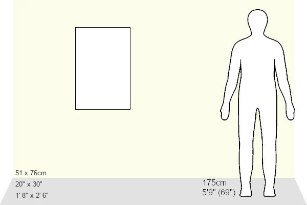
Made in the USA, 1014-piece puzzles measure 20" x 30" (50.8 x 76.2 cm). Every puzzle is meticulously printed on glossy photo paper, which has a strong 1.33 mm thickness. Delivered in a black storage cardboard box, these puzzles are both stylish and practical. (Note: puzzles contain small parts and are not suitable for children under 3 years of age.)
Jigsaw Puzzles are an ideal gift for any occasion
Estimated Product Size is 50.8cm x 76cm (20" x 29.9")
These are individually made so all sizes are approximate
Artwork printed orientated as per the preview above, with portrait (vertical) orientation to match the source image.
FEATURES IN THESE COLLECTIONS
> Africa
> Egypt
> Alexandria
> Africa
> Egypt
> Related Images
> Arts
> Landscape paintings
> Waterfall and river artworks
> River artworks
> Historic
> Ancient civilizations
> Ancient Egypt
> Historic
> Ancient civilizations
> Maps and Charts
> Early Maps
> Maps and Charts
> Related Images
> North Wind Picture Archives
> Ancient history
> North Wind Picture Archives
> Maps
EDITORS COMMENTS
This print showcases a beautifully detailed "Map of ancient Egypt". With its vibrant printed color lithograph, the image transports us back in time to the classical era of this historic civilization. The map encompasses various significant landmarks and cities, such as Alexandria, Memphis, and Thebes, which were once thriving centers of culture and power along the mighty Nile River. The illustration not only captures the geographical layout of ancient Egypt but also offers a glimpse into its rich history. From the majestic pyramids that dot the landscape to intricate hieroglyphics adorning temples and tombs, every element on this map tells a story of an advanced civilization that flourished thousands of years ago. As we explore this vintage artwork, we are reminded of Africa's profound influence on human history. Ancient Egypt stands as a testament to mankind's ability to create enduring legacies through art, architecture, and innovation. This print from North Wind Picture Archives serves as both an educational tool for enthusiasts studying ancient history or classics and a visually stunning piece for those who appreciate art with historical significance. It invites viewers to immerse themselves in the wonders of ancient Egyptian culture while marveling at their remarkable achievements that continue to captivate our imagination today.
MADE IN THE USA
Safe Shipping with 30 Day Money Back Guarantee
FREE PERSONALISATION*
We are proud to offer a range of customisation features including Personalised Captions, Color Filters and Picture Zoom Tools
SECURE PAYMENTS
We happily accept a wide range of payment options so you can pay for the things you need in the way that is most convenient for you
* Options may vary by product and licensing agreement. Zoomed Pictures can be adjusted in the Cart.