Home > South America > Paraguay > Maps
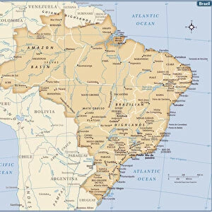
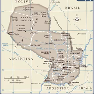
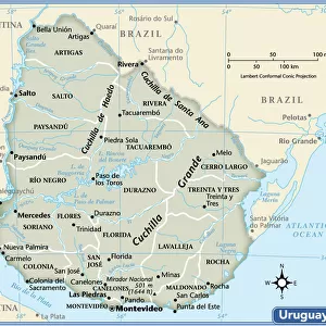
1862, Johnson Map of Brazil, Paraguay, Uruguay and Argentina, topography, cartography

![]()
Wall Art and Photo Gifts from Liszt Collection
1862, Johnson Map of Brazil, Paraguay, Uruguay and Argentina, topography, cartography
1862, Johnson Map of Brazil, Paraguay, Uruguay and Argentina
Liszt Collection of nineteenth-century engravings and images to browse and enjoy
Media ID 14005946
© Artokoloro Quint Lox Limited
1862 Antique Map Atlas Chart Geographic Latitude Longitude Mappa Mundi Old Antique Plan Old Antique View Old Map Ols Antique Map Paraguay Rare Old Maps Topo
FEATURES IN THESE COLLECTIONS
> Maps and Charts
> Early Maps
> Maps and Charts
> World
> South America
> Argentina
> Maps
> South America
> Brazil
> Maps
> South America
> Paraguay
> Maps
> South America
> Uruguay
> Maps
EDITORS COMMENTS
This print showcases a remarkable piece of history - the 1862 Johnson Map of Brazil, Paraguay, Uruguay, and Argentina. A true masterpiece in topography and cartography, this map offers a fascinating glimpse into the geographical landscape of these South American countries during that era. The intricate details depicted on this vintage map are truly awe-inspiring. From the carefully drawn lines representing latitude and longitude to the meticulously illustrated topographic features, every element has been skillfully crafted. This artistic representation not only serves as a navigational tool but also as an exquisite work of art. As we gaze upon this aged treasure, we can't help but be transported back in time to an era when exploration and discovery were at their peak. The historical significance embedded within its paper is palpable - it tells tales of ancient civilizations, long-forgotten journeys, and the rich tapestry of human existence. With its decorative borders and elegant design, this rare old map adds a touch of sophistication to any space it graces. It invites us to embark on our own personal journey through time as we explore the regions it encompasses. Whether you are an avid collector or simply appreciate the beauty found in historical artifacts like this one, owning a print of the 1862 Johnson Map is sure to ignite your sense of wonder for both geography and history alike.
MADE IN THE USA
Safe Shipping with 30 Day Money Back Guarantee
FREE PERSONALISATION*
We are proud to offer a range of customisation features including Personalised Captions, Color Filters and Picture Zoom Tools
SECURE PAYMENTS
We happily accept a wide range of payment options so you can pay for the things you need in the way that is most convenient for you
* Options may vary by product and licensing agreement. Zoomed Pictures can be adjusted in the Cart.