Home > Animals > Insects > Hemiptera > Rose Scale
Sea chart island Sardinia part coast North Africa Passport map

![]()
Wall Art and Photo Gifts from Liszt Collection
Sea chart island Sardinia part coast North Africa Passport map
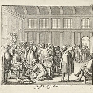
Sea chart of the island of Sardinia and a part of the coast of North Africa Passport map of the sea coasts of the eyland Sardinia with the coast of Barbaria, between the sea C. de Ferro and C. Bona. (title on object), Sea chart of the island of Sardinia and part of the coast of North Africa with an inset map of the island of Tabarca, with three compass roses. Above left the cartouche with the title, flanked by two women with a palm branch and a trumpet. In the center the address of the publisher and the scale, shown in German, Spanish and English or French miles (scale: c. 1: 900 000), armillary sphere, skeleton celestial globe, horn, trumpet, cornet, trombone, tuba, Sardinia, Barbaria, Jan Luyken (rejected attribution), Amsterdam, 1682 - 1803, paper, etching, h 512 mm × w 591 mm
Liszt Collection of nineteenth-century engravings and images to browse and enjoy
Media ID 19539771
© Artokoloro
1682 1803 Address Armillary Sphere Cartouche Center Coast Cornet Flanked French Miles Horn Island Jan Luyken North Africa Palm Branch Rejected Attribution Sardinia Scale Sea Chart Sea Coasts Shown Skeleton Celestial Globe Spanish Three Compass Roses Title Trombone Trumpet Tuba Two Women Bona Publisher
FEATURES IN THESE COLLECTIONS
> Animals
> Fishes
> T
> Trumpeter
> Animals
> Insects
> Hemiptera
> Rose Scale
> Arts
> Artists
> L
> Jan Luyken
> Europe
> Italy
> Sardinia
> Related Images
EDITORS COMMENTS
This print showcases a sea chart of the enchanting island of Sardinia and a portion of the North African coast. The intricate details on this passport map highlight the sea coasts, including Barbaria, between C. de Ferro and C. Bona. The title on the object is written in bold letters, accompanied by an exquisite cartouche flanked by two women holding a palm branch and a trumpet. The publisher's address and scale are prominently displayed at the center, providing measurements in German, Spanish, and English or French miles (scale: approximately 1:900 000). Three compass roses add to the navigational elements depicted on this historic map. Intriguingly, an inset map of Tabarca Island can be found within this larger composition. The attention to detail extends beyond geography as various musical instruments such as horns, trumpets, cornets, trombones, and tubas are intricately etched into the design. Although initially attributed to Jan Luyken but later rejected due to conflicting evidence from Amsterdam between 1682-1803; this remarkable piece is printed on high-quality paper using etching techniques. Measuring approximately 512mm in height and 591mm in width; it beautifully captures both landmasses with precision. This stunning print from Liszt Collection offers viewers a glimpse into history while showcasing the beauty of Sardinia's coastline intertwined with its connection to North Africa's shores.
MADE IN THE USA
Safe Shipping with 30 Day Money Back Guarantee
FREE PERSONALISATION*
We are proud to offer a range of customisation features including Personalised Captions, Color Filters and Picture Zoom Tools
SECURE PAYMENTS
We happily accept a wide range of payment options so you can pay for the things you need in the way that is most convenient for you
* Options may vary by product and licensing agreement. Zoomed Pictures can be adjusted in the Cart.