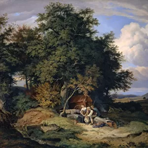
Home > Arts > Artists > W > George White
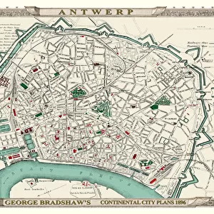
George Bradshaws Plan of Brussels, Belgium 1896

![]()
Wall Art and Photo Gifts from MapSeeker
George Bradshaws Plan of Brussels, Belgium 1896
This is a detailed Plan of Brussels showing the streets, canals, principal buildings, railways and railway stations. The walled inner city is differentiated from the outer part of the city. There is a numbered key to principal buildings and places of interest. It has been meticulously recreated in colour and republished without and fold creases by Mapseeker, from a rare antique original black and white fold up tourist city map. The 29 that were originally published as fold up maps featuring the principal cities of Europe are now rare, yet popular at their time among those who could then explore Europe by railway for the first time
Welcome to the Mapseeker Image library and enter an historic gateway to one of the largest on-line collections of Historic Maps, Nostalgic Views, Vista's and Panorama's from a World gone by.
Media ID 20347985
© Mapseeker Publishing Ltd
Bradshaw City Map Bradshaw City Plan Bradshaw Map Europe City Europe City Plan European City Map European City Plan Historic Map Old Town Plan Brussels
FEATURES IN THESE COLLECTIONS
> Arts
> Artists
> W
> George White
> Arts
> Modern art pieces
> Pop art
> Street art
> Arts
> Photorealistic artworks
> Detailed art pieces
> Masterful detailing in art
> Arts
> Photorealistic artworks
> Meticulous attention to detail
> Detailed artwork
> Arts
> Photorealistic artworks
> Meticulous attention to detail
> Fine art
> MapSeeker
> Maps of Europe
> Maps of Belgium PORTFOLIO
EDITORS COMMENTS
This stunning print showcases George Bradshaw's Plan of Brussels, Belgium from 1896. A true masterpiece of cartography, this detailed plan provides a comprehensive view of the city's streets, canals, principal buildings, railways, and railway stations. The map ingeniously distinguishes the walled inner city from its outer part, offering a glimpse into Brussels' historical layout. Meticulously recreated in vibrant color and free from any fold creases by Mapseeker Publishing Ltd. , this reproduction breathes new life into an antique original black and white fold-up tourist city map. Originally published as one of only 29 fold-up maps featuring Europe's principal cities, these rare gems were highly sought after during their time - especially by those fortunate enough to embark on Europe's first railway adventures. The attention to detail is remarkable; each building and place of interest is numbered for easy reference using a key provided on the map. This piece not only serves as a valuable historical artifact but also offers a fascinating window into Brussels' past. Whether you are an avid collector of historic maps or simply captivated by the charm of old-world cartography, this George Bradshaw creation is sure to transport you back in time to discover the enchanting beauty of Brussels in 1896.
MADE IN THE USA
Safe Shipping with 30 Day Money Back Guarantee
FREE PERSONALISATION*
We are proud to offer a range of customisation features including Personalised Captions, Color Filters and Picture Zoom Tools
SECURE PAYMENTS
We happily accept a wide range of payment options so you can pay for the things you need in the way that is most convenient for you
* Options may vary by product and licensing agreement. Zoomed Pictures can be adjusted in the Cart.