Home > South America > Paraguay > Maps
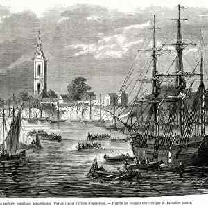
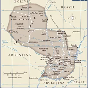
Map of the Paraguayan War 1868

![]()
Wall Art and Photo Gifts from Mary Evans Picture Library
Map of the Paraguayan War 1868
A map of allies positions along the Parana river, up until the capture of Humayta. Date: 1868
Mary Evans Picture Library makes available wonderful images created for people to enjoy over the centuries
Media ID 23089312
© Mary Evans Picture Library
1868 Alliance Allies Argentine Battles Capture Movements Paraguay Paraguayan Parana Positions Triple
FEATURES IN THESE COLLECTIONS
> Historic
> Battles
> Related Images
> Mary Evans Prints Online
> New Images August 2021
> South America
> Paraguay
> Maps
EDITORS COMMENTS
This historic map print, dated 1868, provides a detailed view of the strategic positions of the allied forces during the pivotal moments of the Paraguayan War. The map focuses on the area along the Parana River, highlighting the positions of the Argentine Republic, the Brazilian Empire, and the Uruguayan State, who formed the Triple Alliance to challenge the military rule of Paraguay under the command of Marshal Francisco Solano Lopez. The map illustrates the intricate movements and battles that took place during this protracted conflict, which lasted from 1864 to 1870. The allied forces, seeking to weaken Paraguay's military might, launched a series of offensives along the Parana River, culminating in the capture of the crucial stronghold of Humaita in 1868. The fortress, located on an island in the Parana River, had been a major obstacle for the allied forces, as it controlled access to the river and allowed Paraguay to launch devastating counter-attacks. The map offers valuable insights into the military strategies employed by the allied forces during the Paraguayan War. The intricate details of the map, including the locations of key battle sites, camps, and fortifications, provide a tangible connection to this significant period in South American history. The map is a testament to the complex geopolitical landscape of the region during the late 19th century and the determination of the Triple Alliance to bring an end to Paraguay's military rule. This map print is a valuable addition to any collection of historical maps or South American studies, offering a unique perspective on the military campaigns and strategic maneuvers that shaped the outcome of the Paraguayan War. The intricate details and historical significance make it a must-have for scholars, educators, and history enthusiasts alike.
MADE IN THE USA
Safe Shipping with 30 Day Money Back Guarantee
FREE PERSONALISATION*
We are proud to offer a range of customisation features including Personalised Captions, Color Filters and Picture Zoom Tools
SECURE PAYMENTS
We happily accept a wide range of payment options so you can pay for the things you need in the way that is most convenient for you
* Options may vary by product and licensing agreement. Zoomed Pictures can be adjusted in the Cart.