Metal Print > North America > Dominican Republic > Maps
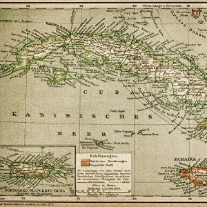
Metal Print : Map Of The Dominican Republic Circa. 1760. From "Atlas De Toutes Les Parties Connues Du Globe Terrestre "By Cartographer Rigobert Bonne. Published Geneva Circa. 1760


![]()
Metal Prints from Design Pics
Map Of The Dominican Republic Circa. 1760. From "Atlas De Toutes Les Parties Connues Du Globe Terrestre "By Cartographer Rigobert Bonne. Published Geneva Circa. 1760
Map Of The Dominican Republic Circa. 1760. From " Atlas De Toutes Les Parties Connues Du Globe Terrestre " By Cartographer Rigobert Bonne. Published Geneva Circa. 1760
Design Pics offers Distinctively Different Imagery representing over 1,500 contributors
Media ID 18186461
© Ken Welsh / Design Pics
Cartography Dominican Geography Mapmaking Plate Republic
16"x24" (61x41cm) Metal Print
Step back in time with our exquisite Metal Print of the Map of the Dominican Republic from the "Atlas De Toutes Les Parties Connues Du Globe Terrestre," published in Geneva circa 1760. This beautiful vintage map, created by renowned cartographer Rigobert Bonne, showcases intricate detail and historical accuracy. The Map of the Dominican Republic during this era is a must-have for history enthusiasts, geography aficionados, and those who appreciate the beauty of antique cartography. Our high-quality Metal Print preserves the intricate lines, colors, and text of the original map, making it a stunning addition to any home or office decor. Bring a piece of the past into your present with our authentic and captivating Metal Print.
Made with durable metal and luxurious printing techniques, our metal photo prints go beyond traditional canvases, adding a cool, modern touch to your space. Wall mount on back. Eco-friendly 100% post-consumer recycled ChromaLuxe aluminum surface. The thickness of the print is 0.045". Featuring a Scratch-resistant surface and Rounded corners. Backing hangers are attached to the back of the print and float the print 1/2-inch off the wall when hung, the choice of hanger may vary depending on size and International orders will come with Float Mount hangers only. Finished with a brilliant white high gloss surface for unsurpassed detail and vibrance. Printed using Dye-Sublimation and for best care we recommend a non-ammonia glass cleaner, water, or isopropyl (rubbing) alcohol to prevent harming the print surface. We recommend using a clean, lint-free cloth to wipe off the print. The ultra-hard surface is scratch-resistant, waterproof and weatherproof. Avoid direct sunlight exposure.
Made with durable metal and luxurious printing techniques, metal prints bring images to life and add a modern touch to any space
Estimated Product Size is 61.5cm x 41.2cm (24.2" x 16.2")
These are individually made so all sizes are approximate
Artwork printed orientated as per the preview above, with landscape (horizontal) orientation to match the source image.
FEATURES IN THESE COLLECTIONS
> Maps and Charts
> Related Images
> North America
> Dominican Republic
> Maps
> North America
> Dominican Republic
> Related Images
EDITORS COMMENTS
This print showcases a remarkable piece of history - the Map of the Dominican Republic circa 1760. Crafted by renowned cartographer Rigobert Bonne and published in Geneva around the same time, this map is a testament to the artistry and precision of early mapmaking. The vibrant colors and intricate details bring this historical artifact to life, offering a glimpse into what was known about the Dominican Republic during that era. The engraving technique used adds depth and texture to each contour line, making it an exquisite work of art. As you explore this horizontal illustration, you can't help but marvel at how geography was depicted without modern technology. This map serves as a reminder of how far we've come in our understanding of our planet's landscapes. Whether you're a history enthusiast or simply appreciate fine craftsmanship, this print is sure to captivate your imagination. It would make for an intriguing addition to any collection or serve as an educational tool for those interested in studying cartography. Ken Welsh has expertly captured every detail with his lens, allowing us all to admire and appreciate this stunning piece from "Atlas De Toutes Les Parties Connues Du Globe Terrestre". So take a moment to immerse yourself in history with this extraordinary print.
MADE IN THE USA
Safe Shipping with 30 Day Money Back Guarantee
FREE PERSONALISATION*
We are proud to offer a range of customisation features including Personalised Captions, Color Filters and Picture Zoom Tools
SECURE PAYMENTS
We happily accept a wide range of payment options so you can pay for the things you need in the way that is most convenient for you
* Options may vary by product and licensing agreement. Zoomed Pictures can be adjusted in the Cart.