Poster Print > North America > Dominican Republic > Maps
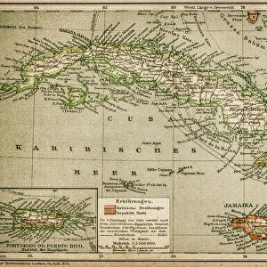
Poster Print : Map Of The Dominican Republic Circa. 1760. From "Atlas De Toutes Les Parties Connues Du Globe Terrestre "By Cartographer Rigobert Bonne. Published Geneva Circa. 1760


![]()
Poster Prints from Design Pics
Map Of The Dominican Republic Circa. 1760. From "Atlas De Toutes Les Parties Connues Du Globe Terrestre "By Cartographer Rigobert Bonne. Published Geneva Circa. 1760
Map Of The Dominican Republic Circa. 1760. From " Atlas De Toutes Les Parties Connues Du Globe Terrestre " By Cartographer Rigobert Bonne. Published Geneva Circa. 1760
Design Pics offers Distinctively Different Imagery representing over 1,500 contributors
Media ID 18186461
© Ken Welsh / Design Pics
Cartography Dominican Geography Mapmaking Plate Republic
18x24 inch Poster Print
Step back in time with our vintage Map of the Dominican Republic from the "Atlas De Toutes Les Parties Connues Du Globe Terrestre" by renowned cartographer Rigobert Bonne. Published in Geneva circa 1760, this antique print showcases intricate detail and historical accuracy. Bring a touch of history and world exploration into your home or office with this beautiful and authentic poster print from Media Storehouse.
Poster prints are budget friendly enlarged prints in standard poster paper sizes. Printed on 150 gsm Matte Paper for a natural feel and supplied rolled in a tube. Great for framing and should last many years. To clean wipe with a microfiber, non-abrasive cloth or napkin. Our Archival Quality Photo Prints and Fine Art Paper Prints are printed on higher quality paper and the choice of which largely depends on your budget.
Poster prints are budget friendly enlarged prints in standard poster paper sizes (A0, A1, A2, A3 etc). Whilst poster paper is sometimes thinner and less durable than our other paper types, they are still ok for framing and should last many years. Our Archival Quality Photo Prints and Fine Art Paper Prints are printed on higher quality paper and the choice of which largely depends on your budget.
Estimated Product Size is 61.6cm x 46.3cm (24.3" x 18.2")
These are individually made so all sizes are approximate
Artwork printed orientated as per the preview above, with landscape (horizontal) orientation to match the source image.
FEATURES IN THESE COLLECTIONS
> Maps and Charts
> Related Images
> North America
> Dominican Republic
> Maps
> North America
> Dominican Republic
> Related Images
EDITORS COMMENTS
This print showcases a remarkable piece of history - the Map of the Dominican Republic circa 1760. Crafted by renowned cartographer Rigobert Bonne and published in Geneva around the same time, this map is a testament to the artistry and precision of early mapmaking. The vibrant colors and intricate details bring this historical artifact to life, offering a glimpse into what was known about the Dominican Republic during that era. The engraving technique used adds depth and texture to each contour line, making it an exquisite work of art. As you explore this horizontal illustration, you can't help but marvel at how geography was depicted without modern technology. This map serves as a reminder of how far we've come in our understanding of our planet's landscapes. Whether you're a history enthusiast or simply appreciate fine craftsmanship, this print is sure to captivate your imagination. It would make for an intriguing addition to any collection or serve as an educational tool for those interested in studying cartography. Ken Welsh has expertly captured every detail with his lens, allowing us all to admire and appreciate this stunning piece from "Atlas De Toutes Les Parties Connues Du Globe Terrestre". So take a moment to immerse yourself in history with this extraordinary print.
MADE IN THE USA
Safe Shipping with 30 Day Money Back Guarantee
FREE PERSONALISATION*
We are proud to offer a range of customisation features including Personalised Captions, Color Filters and Picture Zoom Tools
SECURE PAYMENTS
We happily accept a wide range of payment options so you can pay for the things you need in the way that is most convenient for you
* Options may vary by product and licensing agreement. Zoomed Pictures can be adjusted in the Cart.