Metal Print > Arts > Artists > B > Willem Blaeu
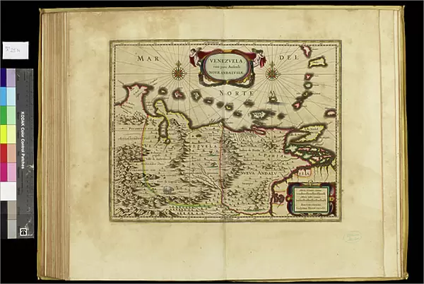
Metal Print : Geography map: representation of Venezuela in South America from an Atlas made by cartographer Willem Janszoon Blaeu (1571-1638), approximately 1630 Biblioteca Angelica, Rome
, approximately 1630 Biblioteca Angelica, Rome")

![]()
Metal Prints from Fine Art Finder
Geography map: representation of Venezuela in South America from an Atlas made by cartographer Willem Janszoon Blaeu (1571-1638), approximately 1630 Biblioteca Angelica, Rome
VEN5030346 Geography map: representation of Venezuela in South America from an Atlas made by cartographer Willem Janszoon Blaeu (1571-1638), approximately 1630 Biblioteca Angelica, Rome; (add.info.: Geography map: representation of Venezuela in South America from an Atlas made by cartographer Willem Janszoon Blaeu (1571-1638), approximately 1630 Biblioteca Angelica, Rome); © Marage Photos
Media ID 38350288
© © Marage Photos / Bridgeman Images
17eme Siecle Amerique Du Nord Amerique Du Sud Carte Geographique Etats Unis Geographie Latin America Stockravenna Venezuela Venezuelan 17th Centuries Etats Unis Etats Unis Usa United States Geographical Map Latine America
16"x24" (61x41cm) Metal Print
Step into the past with our Metal Prints, featuring stunning historical maps like this rare representation of Venezuela in South America from an Atlas made by cartographer Willem Janszoon Blaeu. Printed on high-quality metal for a sleek and modern look, these prints are perfect for history buffs and anyone who loves vintage design. Bring a touch of the past into your home or office with our Media Storehouse range.
Made with durable metal and luxurious printing techniques, our metal photo prints go beyond traditional canvases, adding a cool, modern touch to your space. Wall mount on back. Eco-friendly 100% post-consumer recycled ChromaLuxe aluminum surface. The thickness of the print is 0.045". Featuring a Scratch-resistant surface and Rounded corners. Backing hangers are attached to the back of the print and float the print 1/2-inch off the wall when hung, the choice of hanger may vary depending on size and International orders will come with Float Mount hangers only. Finished with a brilliant white high gloss surface for unsurpassed detail and vibrance. Printed using Dye-Sublimation and for best care we recommend a non-ammonia glass cleaner, water, or isopropyl (rubbing) alcohol to prevent harming the print surface. We recommend using a clean, lint-free cloth to wipe off the print. The ultra-hard surface is scratch-resistant, waterproof and weatherproof. Avoid direct sunlight exposure.
Made with durable metal and luxurious printing techniques, metal prints bring images to life and add a modern touch to any space
Estimated Product Size is 61.5cm x 41.2cm (24.2" x 16.2")
These are individually made so all sizes are approximate
Artwork printed orientated as per the preview above, with landscape (horizontal) orientation to match the source image.
FEATURES IN THESE COLLECTIONS
> Fine Art Finder
> Artists
> Francois Xavier Fabre
> Arts
> Artists
> B
> Willem Blaeu
> Maps and Charts
> Early Maps
> North America
> United States of America
> Maps
> South America
> Related Images
> South America
> Venezuela
> Maps
> South America
> Venezuela
> Related Images
EDITORS COMMENTS
This stunning print captures a detailed geography map of Venezuela in South America, created by the renowned cartographer Willem Janszoon Blaeu in approximately 1630. The intricate details and accuracy of this representation showcase the skill and expertise of Blaeu, who was known for his exceptional cartographic work during the 17th century.
The map is part of an Atlas housed in the Biblioteca Angelica in Rome, providing a glimpse into historical geographical knowledge and exploration from that time period. The rich colors and fine lines used to depict Venezuela highlight the beauty and complexity of this South American country.
As we study this map, we are transported back in time to an era when cartographers meticulously charted unknown territories, expanding our understanding of the world around us. The inclusion of Venezuela within this atlas serves as a reminder of the importance of geography in shaping our perceptions and interactions with different regions.
Overall, this print not only showcases a piece of history but also invites us to appreciate the artistry and dedication that went into creating such detailed maps centuries ago. It is a testament to human curiosity and ingenuity that continues to inspire exploration and discovery today.
MADE IN THE USA
Safe Shipping with 30 Day Money Back Guarantee
FREE PERSONALISATION*
We are proud to offer a range of customisation features including Personalised Captions, Color Filters and Picture Zoom Tools
SECURE PAYMENTS
We happily accept a wide range of payment options so you can pay for the things you need in the way that is most convenient for you
* Options may vary by product and licensing agreement. Zoomed Pictures can be adjusted in the Cart.