Metal Print > Europe > France > Maps
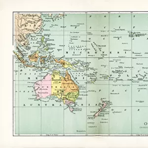
Metal Print : Map showing the principal world trade shipping routes, 1912 (colour litho)
")


![]()
Metal Prints from Fine Art Finder
Map showing the principal world trade shipping routes, 1912 (colour litho)
CHT277054 Map showing the principal world trade shipping routes, 1912 (colour litho) by French School, (20th century); Private Collection; (add.info.: Planisphere Commercial; economic history; Atlas du Cours Moyen; from a geography school text book for primary schools; ); eArchives Charmet; French, out of copyright
Media ID 23379292
© Archives Charmet / Bridgeman Images
16"x24" (61x41cm) Metal Print
Discover the rich history of global trade with our stunning Metal Print of a 1912 World Trade Shipping Routes Map. This captivating coloured lithograph, hailing from the French School of the 20th century, showcases the principal shipping routes that once connected the world. A beautiful addition to any home or office, this Metal Print from Media Storehouse, featuring the Bridgeman Images from Fine Art Finder (CHT277054), is not only an exquisite piece of art but also a testament to the enduring legacy of international commerce. Bring the past to life with this unique and intriguing display.
Made with durable metal and luxurious printing techniques, our metal photo prints go beyond traditional canvases, adding a cool, modern touch to your space. Wall mount on back. Eco-friendly 100% post-consumer recycled ChromaLuxe aluminum surface. The thickness of the print is 0.045". Featuring a Scratch-resistant surface and Rounded corners. Backing hangers are attached to the back of the print and float the print 1/2-inch off the wall when hung, the choice of hanger may vary depending on size and International orders will come with Float Mount hangers only. Finished with a brilliant white high gloss surface for unsurpassed detail and vibrance. Printed using Dye-Sublimation and for best care we recommend a non-ammonia glass cleaner, water, or isopropyl (rubbing) alcohol to prevent harming the print surface. We recommend using a clean, lint-free cloth to wipe off the print. The ultra-hard surface is scratch-resistant, waterproof and weatherproof. Avoid direct sunlight exposure.
Made with durable metal and luxurious printing techniques, metal prints bring images to life and add a modern touch to any space
Estimated Product Size is 61.5cm x 41.2cm (24.2" x 16.2")
These are individually made so all sizes are approximate
Artwork printed orientated as per the preview above, with landscape (horizontal) orientation to match the source image.
FEATURES IN THESE COLLECTIONS
> Fine Art Finder
> Artists
> French School
> Fine Art Finder
> Maps (celestial & Terrestrial)
> Maps and Charts
> Related Images
> Maps and Charts
> World
EDITORS COMMENTS
This print titled "Map showing the principal world trade shipping routes, 1912" takes us back in time to a crucial period in global commerce and economic history. Created by the French School in the early 20th century, this colourful lithograph offers a glimpse into the intricate web of international trade during that era. The map, known as Planisphere Commercial, was originally featured in a geography school textbook for primary schools called Atlas du Cours Moyen. It showcases the major shipping routes that connected various ports around the world at that time. With meticulous detail and vibrant hues, it highlights how ships played an instrumental role in facilitating global trade and shaping economies. As we study this remarkable piece of art, we are reminded of the immense significance of maritime transportation in fostering economic growth and intercontinental connections. The map not only serves as a historical document but also sparks curiosity about how these routes have evolved over time. Displayed here from a private collection with permission from eArchives Charmet, this image is now part of public domain due to its age. It stands as a testament to human ingenuity and ambition when it comes to expanding commercial horizons across vast oceans. Whether you're interested in ships or fascinated by global economics and industry, this print captures an essential chapter in our shared history – one where nations were interconnected through bustling ports and thriving trade networks.
MADE IN THE USA
Safe Shipping with 30 Day Money Back Guarantee
FREE PERSONALISATION*
We are proud to offer a range of customisation features including Personalised Captions, Color Filters and Picture Zoom Tools
SECURE PAYMENTS
We happily accept a wide range of payment options so you can pay for the things you need in the way that is most convenient for you
* Options may vary by product and licensing agreement. Zoomed Pictures can be adjusted in the Cart.