Photographic Print > Europe > France > Maps
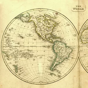
Photographic Print : Map showing the principal world trade shipping routes, 1912 (colour litho)
")

![]()
Photo Prints from Fine Art Finder
Map showing the principal world trade shipping routes, 1912 (colour litho)
CHT277054 Map showing the principal world trade shipping routes, 1912 (colour litho) by French School, (20th century); Private Collection; (add.info.: Planisphere Commercial; economic history; Atlas du Cours Moyen; from a geography school text book for primary schools; ); eArchives Charmet; French, out of copyright
Media ID 23379292
© Archives Charmet / Bridgeman Images
11"x8.5" Photo Print
Step back in time with our exquisite Map showing the principal world trade shipping routes, 1912 (CHT277054) by Bridgeman Images from Fine Art Finder. This stunning, color lithograph by the French School depicts the intricate web of global maritime trade routes during the early 20th century. Add an air of historical sophistication to your home or office with this captivating piece of art, a window into the past that tells a story of global connections and economic history.
Photo prints are produced on Kodak professional photo paper resulting in timeless and breath-taking prints which are also ideal for framing. The colors produced are rich and vivid, with accurate blacks and pristine whites, resulting in prints that are truly timeless and magnificent. Whether you're looking to display your prints in your home, office, or gallery, our range of photographic prints are sure to impress. Dimensions refers to the size of the paper in inches.
Our Photo Prints are in a large range of sizes and are printed on Archival Quality Paper for excellent colour reproduction and longevity. They are ideal for framing (our Framed Prints use these) at a reasonable cost. Alternatives include cheaper Poster Prints and higher quality Fine Art Paper, the choice of which is largely dependant on your budget.
Estimated Image Size (if not cropped) is 27.9cm x 15.7cm (11" x 6.2")
Estimated Product Size is 27.9cm x 21.6cm (11" x 8.5")
These are individually made so all sizes are approximate
Artwork printed orientated as per the preview above, with landscape (horizontal) orientation to match the source image.
FEATURES IN THESE COLLECTIONS
> Fine Art Finder
> Artists
> French School
> Fine Art Finder
> Maps (celestial & Terrestrial)
> Maps and Charts
> Related Images
> Maps and Charts
> World
EDITORS COMMENTS
This print titled "Map showing the principal world trade shipping routes, 1912" takes us back in time to a crucial period in global commerce and economic history. Created by the French School in the early 20th century, this colourful lithograph offers a glimpse into the intricate web of international trade during that era. The map, known as Planisphere Commercial, was originally featured in a geography school textbook for primary schools called Atlas du Cours Moyen. It showcases the major shipping routes that connected various ports around the world at that time. With meticulous detail and vibrant hues, it highlights how ships played an instrumental role in facilitating global trade and shaping economies. As we study this remarkable piece of art, we are reminded of the immense significance of maritime transportation in fostering economic growth and intercontinental connections. The map not only serves as a historical document but also sparks curiosity about how these routes have evolved over time. Displayed here from a private collection with permission from eArchives Charmet, this image is now part of public domain due to its age. It stands as a testament to human ingenuity and ambition when it comes to expanding commercial horizons across vast oceans. Whether you're interested in ships or fascinated by global economics and industry, this print captures an essential chapter in our shared history – one where nations were interconnected through bustling ports and thriving trade networks.
MADE IN THE USA
Safe Shipping with 30 Day Money Back Guarantee
FREE PERSONALISATION*
We are proud to offer a range of customisation features including Personalised Captions, Color Filters and Picture Zoom Tools
SECURE PAYMENTS
We happily accept a wide range of payment options so you can pay for the things you need in the way that is most convenient for you
* Options may vary by product and licensing agreement. Zoomed Pictures can be adjusted in the Cart.