Metal Print > Africa > South Africa > Maps
Metal Print : French map of the Transvaal at the outbreak of the Boer War in South Africa, 1899


![]()
Metal Prints from Fine Art Finder
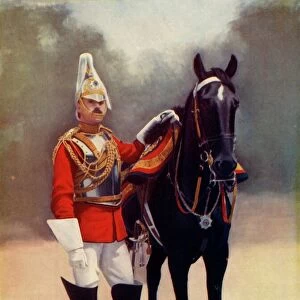
French map of the Transvaal at the outbreak of the Boer War in South Africa, 1899
3479681 French map of the Transvaal at the outbreak of the Boer War in South Africa, 1899; Universal History Archive/UIG
Media ID 38473394
© Universal History Archive/UIG / Bridgeman Images
Boer War Contagion Disease Epidemic Illness Outbreak Pandemic Second Boer War Sick Sickness South African Wars Transvaal
16"x20" (51x41cm) Metal Print
Step into history with our Media Storehouse range of Metal Prints! This stunning piece features a vintage map from Bridgeman Images' Fine Art Finder collection, showcasing "French Map of the Transvaal at the Outbreak of the Boer War in South Africa, 1899". With its intricate details and rich colors, this metal print is sure to be a conversation starter. Perfect for history buffs, art enthusiasts, or anyone looking to add a touch of nostalgia to their space.
Made with durable metal and luxurious printing techniques, our metal photo prints go beyond traditional canvases, adding a cool, modern touch to your space. Wall mount on back. Eco-friendly 100% post-consumer recycled ChromaLuxe aluminum surface. The thickness of the print is 0.045". Featuring a Scratch-resistant surface and Rounded corners. Backing hangers are attached to the back of the print and float the print 1/2-inch off the wall when hung, the choice of hanger may vary depending on size and International orders will come with Float Mount hangers only. Finished with a brilliant white high gloss surface for unsurpassed detail and vibrance. Printed using Dye-Sublimation and for best care we recommend a non-ammonia glass cleaner, water, or isopropyl (rubbing) alcohol to prevent harming the print surface. We recommend using a clean, lint-free cloth to wipe off the print. The ultra-hard surface is scratch-resistant, waterproof and weatherproof. Avoid direct sunlight exposure.
Made with durable metal and luxurious printing techniques, metal prints bring images to life and add a modern touch to any space
Estimated Image Size (if not cropped) is 40.6cm x 50.8cm (16" x 20")
Estimated Product Size is 41.2cm x 51.4cm (16.2" x 20.2")
These are individually made so all sizes are approximate
Artwork printed orientated as per the preview above, with portrait (vertical) orientation to match the source image.
FEATURES IN THESE COLLECTIONS
> Fine Art Finder
> Artists
> Unknown photographer
> Africa
> South Africa
> Maps
> Africa
> South Africa
> Related Images
> Maps and Charts
> Early Maps
> Maps and Charts
> Related Images
EDITORS COMMENTS
This French map of the Transvaal at the outbreak of the Boer War in South Africa, 1899, offers a glimpse into a tumultuous period in history. The intricate details and historical significance captured in this print transport us back to a time of conflict and upheaval.
As we study the map closely, we can imagine the strategic maneuvers and battles that took place during the Boer War. The lines and markings on the map tell a story of power struggles, territorial disputes, and political tensions that defined this era.
The outbreak of war is symbolized by the bold lines and shaded areas on the map, highlighting key locations where significant events unfolded. It serves as a reminder of the human cost of conflict and war, as well as the complex geopolitical dynamics at play during this time.
Through this visual representation, we are reminded of how maps not only serve as navigational tools but also as historical artifacts that document important moments in time. This French map is not just a piece of paper; it is a window into an era marked by turmoil and change.
MADE IN THE USA
Safe Shipping with 30 Day Money Back Guarantee
FREE PERSONALISATION*
We are proud to offer a range of customisation features including Personalised Captions, Color Filters and Picture Zoom Tools
SECURE PAYMENTS
We happily accept a wide range of payment options so you can pay for the things you need in the way that is most convenient for you
* Options may vary by product and licensing agreement. Zoomed Pictures can be adjusted in the Cart.