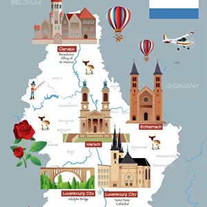
Metal Print > Europe > Poland > Maps
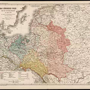
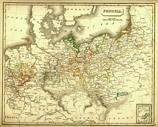
Metal Print : Antquie Map of Prussia


![]()
Metal Prints from Fine Art Storehouse
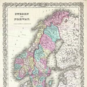
Antquie Map of Prussia
Vintage map of Prussia from 1837
Unleash your creativity and transform your space into a visual masterpiece!
duncan1890
Media ID 13597643
© duncan1890
1830 1839 Baltic Sea Bavaria Berlin Central Europe Chart Denmark Eastern Europe Equipment European Culture Geographical Locations German Culture German North Sea Region Hanover Historical Geopolitical Location Image Created 1830 1839 Image Date Manufactured Object Navigational Equipment Nordic Countries North Sea Northern Europe Objects Equipment Past Poland Pomerania Prussia Retro Revival Saxony Scandinavia Silesia Styles Traditional Culture Berlin Germany Hannover Image Created 19th Century Obsolete Retro Styled Scandinavian Peninsula Victorian Style
16"x20" (51x41cm) Metal Print
Step back in time with our exquisite Metal Print of an Antique Map of Prussia, skillfully crafted by duncan1890 from the Fine Art Storehouse. This vintage map, originally published in 1837, showcases the historical territories and borders of Prussia in intricate detail. The high-quality Metal Print process enhances the rich colors and textures of the map, making it a stunning addition to any room. Preserve history and add a touch of elegance to your space with this unique and captivating piece.
Made with durable metal and luxurious printing techniques, our metal photo prints go beyond traditional canvases, adding a cool, modern touch to your space. Wall mount on back. Eco-friendly 100% post-consumer recycled ChromaLuxe aluminum surface. The thickness of the print is 0.045". Featuring a Scratch-resistant surface and Rounded corners. Backing hangers are attached to the back of the print and float the print 1/2-inch off the wall when hung, the choice of hanger may vary depending on size and International orders will come with Float Mount hangers only. Finished with a brilliant white high gloss surface for unsurpassed detail and vibrance. Printed using Dye-Sublimation and for best care we recommend a non-ammonia glass cleaner, water, or isopropyl (rubbing) alcohol to prevent harming the print surface. We recommend using a clean, lint-free cloth to wipe off the print. The ultra-hard surface is scratch-resistant, waterproof and weatherproof. Avoid direct sunlight exposure.
Made with durable metal and luxurious printing techniques, metal prints bring images to life and add a modern touch to any space
Estimated Image Size (if not cropped) is 50.8cm x 40.6cm (20" x 16")
Estimated Product Size is 51.4cm x 41.2cm (20.2" x 16.2")
These are individually made so all sizes are approximate
Artwork printed orientated as per the preview above, with landscape (horizontal) orientation to match the source image.
FEATURES IN THESE COLLECTIONS
> Fine Art Storehouse
> Map
> Denmark Maps
> Fine Art Storehouse
> Map
> Historical Maps
> Europe
> Denmark
> Related Images
> Europe
> Germany
> Related Images
EDITORS COMMENTS
This print showcases an exquisite "Antique Map of Prussia" dating back to 1837. A true gem from the past, this vintage map offers a glimpse into the historical geopolitical location of Prussia during the 19th century. The intricate cartography highlights various regions such as Dolnoslaskie Province, Silesia, and even extends to Nordic countries like Denmark and Scandinavia. With its Victorian-style design and retro revival aesthetic, this image transports us back in time to an era when navigational equipment relied on beautifully crafted charts like these. The detailed depiction of Baltic Sea and North Sea regions adds depth to our understanding of European culture at that time. As we explore this antique piece further, we discover capital cities like Berlin and Hanover along with other prominent German regions including Bavaria and Saxony. It is fascinating how this map captures not only the geographical locations but also reflects the traditional cultures prevalent in Eastern Europe during that period. Manufactured objects like this hold immense historical value, reminding us of a bygone era where photography was still in its infancy. This horizontal composition evokes nostalgia for a time when maps were indispensable tools for exploration and navigation. Intriguingly devoid of people, Duncan1890's photograph allows us to focus solely on the beauty and significance of this 19th-century relic. Whether you are a history enthusiast or simply appreciate fine art pieces that transport you through time, this print is sure to captivate your imagination with its rich cultural heritage
MADE IN THE USA
Safe Shipping with 30 Day Money Back Guarantee
FREE PERSONALISATION*
We are proud to offer a range of customisation features including Personalised Captions, Color Filters and Picture Zoom Tools
SECURE PAYMENTS
We happily accept a wide range of payment options so you can pay for the things you need in the way that is most convenient for you
* Options may vary by product and licensing agreement. Zoomed Pictures can be adjusted in the Cart.