Metal Print > Asia > Palestine > Maps
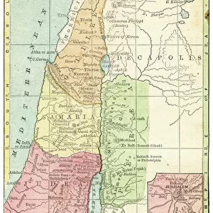
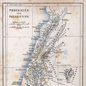
Metal Print : Map of Palestine 1889


![]()
Metal Prints from Fine Art Storehouse
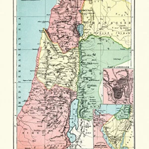
Map of Palestine 1889
Comprehensive Geography by James Monteith - American Book Company 1882, 1889
Unleash your creativity and transform your space into a visual masterpiece!
THEPALMER
Media ID 18357319
16"x24" (61x41cm) Metal Print
Discover the historical depth of this intriguing Map of Palestine from 1889, meticulously reproduced as a stunning Metal Print from Media Storehouse. Originally published in Comprehensive Geography by James Monteith from the American Book Company, this rare and captivating map is now transformed into a contemporary work of art. The high-quality metal print process ensures vibrant colors and sharp details, bringing the intricacies of this historical map to life. Add a touch of history and geography to your space with this unique and beautiful piece.
Made with durable metal and luxurious printing techniques, our metal photo prints go beyond traditional canvases, adding a cool, modern touch to your space. Wall mount on back. Eco-friendly 100% post-consumer recycled ChromaLuxe aluminum surface. The thickness of the print is 0.045". Featuring a Scratch-resistant surface and Rounded corners. Backing hangers are attached to the back of the print and float the print 1/2-inch off the wall when hung, the choice of hanger may vary depending on size and International orders will come with Float Mount hangers only. Finished with a brilliant white high gloss surface for unsurpassed detail and vibrance. Printed using Dye-Sublimation and for best care we recommend a non-ammonia glass cleaner, water, or isopropyl (rubbing) alcohol to prevent harming the print surface. We recommend using a clean, lint-free cloth to wipe off the print. The ultra-hard surface is scratch-resistant, waterproof and weatherproof. Avoid direct sunlight exposure.
Made with durable metal and luxurious printing techniques, metal prints bring images to life and add a modern touch to any space
Estimated Product Size is 41.2cm x 61.5cm (16.2" x 24.2")
These are individually made so all sizes are approximate
Artwork printed orientated as per the preview above, with portrait (vertical) orientation to match the source image.
FEATURES IN THESE COLLECTIONS
> Fine Art Storehouse
> Map
> Historical Maps
> Asia
> Palestine
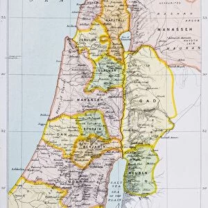
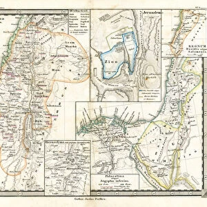
> Related Images
> Maps and Charts
> Related Images
EDITORS COMMENTS
In this print titled "Map of Palestine 1889" we are transported back in time to the late 19th century, immersing ourselves in an era where cartography was both a science and an art form. The image showcases a meticulously detailed map from James Monteith's renowned book "Comprehensive Geography" published by the American Book Company in 1882 and updated in 1889. The map itself is a testament to the immense knowledge and dedication of its creator, as it offers us a comprehensive view of Palestine during that period. Every contour, river, city, and border has been intricately etched onto paper with utmost precision. It serves as a window into history, allowing us to explore the geopolitical landscape of Palestine at that specific point in time. As we gaze upon this remarkable piece from THEPALMER collection at Fine Art Storehouse, our curiosity is piqued by the countless stories waiting to be discovered within these ancient borders. We can almost imagine explorers poring over similar maps during their expeditions or scholars using them as reference material for their academic pursuits. This print not only captures the beauty and historical significance of cartographic art but also invites us to reflect on how our understanding of geography has evolved over time. It reminds us that maps are not merely tools for navigation; they hold within them layers of cultural heritage and human experiences that shape our perception of the world around us.
MADE IN THE USA
Safe Shipping with 30 Day Money Back Guarantee
FREE PERSONALISATION*
We are proud to offer a range of customisation features including Personalised Captions, Color Filters and Picture Zoom Tools
SECURE PAYMENTS
We happily accept a wide range of payment options so you can pay for the things you need in the way that is most convenient for you
* Options may vary by product and licensing agreement. Zoomed Pictures can be adjusted in the Cart.