Photographic Print > Asia > Palestine > Maps
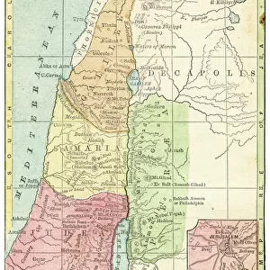
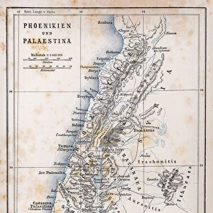
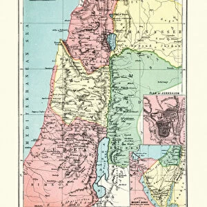
Photographic Print : Map of Palestine 1889


![]()
Photo Prints from Fine Art Storehouse
Map of Palestine 1889
Comprehensive Geography by James Monteith - American Book Company 1882, 1889
Unleash your creativity and transform your space into a visual masterpiece!
THEPALMER
Media ID 18357319
12"x8" Photo Print
Step back in time with our exquisite 'Map of Palestine 1889' print from ThePalmer's Comprehensive Geography, published by the American Book Company in 1889. This captivating historical art piece showcases an intricate and detailed representation of the geography of Palestine during that era. Perfect for history enthusiasts, geography collectors, or anyone seeking to add a touch of the past to their decor. The high-quality photographic print brings the rich history of Palestine to life, making it a treasure for any home or office.
Photo prints are produced on Kodak professional photo paper resulting in timeless and breath-taking prints which are also ideal for framing. The colors produced are rich and vivid, with accurate blacks and pristine whites, resulting in prints that are truly timeless and magnificent. Whether you're looking to display your prints in your home, office, or gallery, our range of photographic prints are sure to impress. Dimensions refers to the size of the paper in inches.
Our Photo Prints are in a large range of sizes and are printed on Archival Quality Paper for excellent colour reproduction and longevity. They are ideal for framing (our Framed Prints use these) at a reasonable cost. Alternatives include cheaper Poster Prints and higher quality Fine Art Paper, the choice of which is largely dependant on your budget.
Estimated Product Size is 20.3cm x 30.5cm (8" x 12")
These are individually made so all sizes are approximate
Artwork printed orientated as per the preview above, with portrait (vertical) orientation to match the source image.
FEATURES IN THESE COLLECTIONS
> Fine Art Storehouse
> Map
> Historical Maps
> Asia
> Palestine
> Related Images
> Maps and Charts
> Related Images
EDITORS COMMENTS
In this print titled "Map of Palestine 1889" we are transported back in time to the late 19th century, immersing ourselves in an era where cartography was both a science and an art form. The image showcases a meticulously detailed map from James Monteith's renowned book "Comprehensive Geography" published by the American Book Company in 1882 and updated in 1889. The map itself is a testament to the immense knowledge and dedication of its creator, as it offers us a comprehensive view of Palestine during that period. Every contour, river, city, and border has been intricately etched onto paper with utmost precision. It serves as a window into history, allowing us to explore the geopolitical landscape of Palestine at that specific point in time. As we gaze upon this remarkable piece from THEPALMER collection at Fine Art Storehouse, our curiosity is piqued by the countless stories waiting to be discovered within these ancient borders. We can almost imagine explorers poring over similar maps during their expeditions or scholars using them as reference material for their academic pursuits. This print not only captures the beauty and historical significance of cartographic art but also invites us to reflect on how our understanding of geography has evolved over time. It reminds us that maps are not merely tools for navigation; they hold within them layers of cultural heritage and human experiences that shape our perception of the world around us.
MADE IN THE USA
Safe Shipping with 30 Day Money Back Guarantee
FREE PERSONALISATION*
We are proud to offer a range of customisation features including Personalised Captions, Color Filters and Picture Zoom Tools
SECURE PAYMENTS
We happily accept a wide range of payment options so you can pay for the things you need in the way that is most convenient for you
* Options may vary by product and licensing agreement. Zoomed Pictures can be adjusted in the Cart.