Metal Print > Fine Art Storehouse > Map > Reference Maps
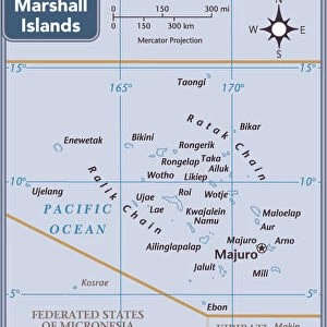
Metal Print : Kiribati country map


Please select a smaller print size for this image
![]()
from Fine Art Storehouse
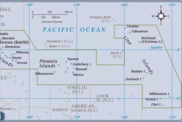
Kiribati country map
2011 edition
Unleash your creativity and transform your space into a visual masterpiece!
Media ID 14432439
16"x24" (61x41cm) Metal Print
Made with durable metal and luxurious printing techniques, our metal photo prints go beyond traditional canvases, adding a cool, modern touch to your space. Wall mount on back. Eco-friendly 100% post-consumer recycled ChromaLuxe aluminum surface. The thickness of the print is 0.045". Featuring a Scratch-resistant surface and Rounded corners. Backing hangers are attached to the back of the print and float the print 1/2-inch off the wall when hung, the choice of hanger may vary depending on size and International orders will come with Float Mount hangers only. Finished with a brilliant white high gloss surface for unsurpassed detail and vibrance. Printed using Dye-Sublimation and for best care we recommend a non-ammonia glass cleaner, water, or isopropyl (rubbing) alcohol to prevent harming the print surface. We recommend using a clean, lint-free cloth to wipe off the print. The ultra-hard surface is scratch-resistant, waterproof and weatherproof. Avoid direct sunlight exposure.
Made with durable metal and luxurious printing techniques, metal prints bring images to life and add a modern touch to any space
Estimated Product Size is 61.5cm x 41.2cm (24.2" x 16.2")
These are individually made so all sizes are approximate
Artwork printed orientated as per the preview above, with landscape (horizontal) orientation to match the source image.
EDITORS COMMENTS
This print showcases the Kiribati country map, specifically the 2011 edition. The vibrant colors and intricate details of this artwork make it a stunning addition to any space. The map depicts the beautiful archipelago of Kiribati, an island nation located in the central Pacific Ocean. With its turquoise waters and lush greenery, Kiribati is truly a tropical paradise. This print allows you to explore and appreciate the unique geography of this remote destination. From Tarawa Atoll to Kiritimati Island (also known as Christmas Island), every atoll and island is meticulously illustrated on this map. It not only serves as a visual representation but also provides valuable information about major cities, towns, and geographical features within Kiribati. Whether you have a personal connection to this enchanting country or simply admire its natural beauty, this print will transport you straight into its idyllic landscapes. Hang it in your living room or office space for a daily reminder of the world's diverse wonders.
MADE IN THE USA
Safe Shipping with 30 Day Money Back Guarantee
FREE PERSONALISATION*
We are proud to offer a range of customisation features including Personalised Captions, Color Filters and Picture Zoom Tools
SECURE PAYMENTS
We happily accept a wide range of payment options so you can pay for the things you need in the way that is most convenient for you
* Options may vary by product and licensing agreement. Zoomed Pictures can be adjusted in the Cart.