Metal Print > Arts > Contemporary art > Digital artwork > Street art
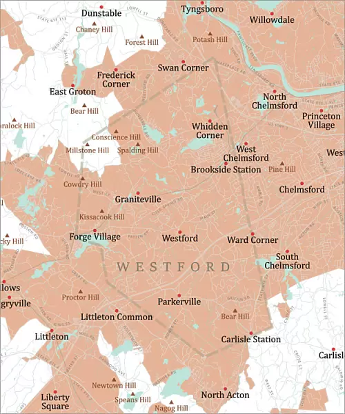
Metal Print : MA Middlesex Westford Vector Road Map

![]()
Metal Prints from Fine Art Storehouse
MA Middlesex Westford Vector Road Map
MA Middlesex Westford Vector Road Map. All source data is in the public domain. U.S. Census Bureau Census Tiger. Used Layers: areawater, linearwater, roads, rails, cousub, pointlm, uac10
Unleash your creativity and transform your space into a visual masterpiece!
Frank Ramspott
Media ID 20691055
© Frank Ramspott, all rights reserved
City Map Computer Graphic County Digital Composite District Geographical Border Massachusetts Middlesex Road Map Text Vector Carlisle Chelmsford Digitally Generated Image Littleton
20"x24" (61x51cm) Metal Print
Discover the unique blend of art and functionality with our Media Storehouse Metal Prints featuring the MA Middlesex Westford Vector Road Map by Frank Ramspott from Fine Art Storehouse. This stunning piece is not just a map, but a work of art, meticulously crafted from public domain data including roads, rails, and waterways. Each metal print is printed directly onto a high-quality aluminum sheet, ensuring vibrant colors and exceptional durability. Bring the intricacies of Middlesex, Westford's road network into your home or office, and add a touch of modern, industrial style to your space. Order yours today and enjoy the beauty of art and the practicality of a map in perfect harmony.
Made with durable metal and luxurious printing techniques, our metal photo prints go beyond traditional canvases, adding a cool, modern touch to your space. Wall mount on back. Eco-friendly 100% post-consumer recycled ChromaLuxe aluminum surface. The thickness of the print is 0.045". Featuring a Scratch-resistant surface and Rounded corners. Backing hangers are attached to the back of the print and float the print 1/2-inch off the wall when hung, the choice of hanger may vary depending on size and International orders will come with Float Mount hangers only. Finished with a brilliant white high gloss surface for unsurpassed detail and vibrance. Printed using Dye-Sublimation and for best care we recommend a non-ammonia glass cleaner, water, or isopropyl (rubbing) alcohol to prevent harming the print surface. We recommend using a clean, lint-free cloth to wipe off the print. The ultra-hard surface is scratch-resistant, waterproof and weatherproof. Avoid direct sunlight exposure.
Made with durable metal and luxurious printing techniques, metal prints bring images to life and add a modern touch to any space
Estimated Image Size (if not cropped) is 50.8cm x 60.9cm (20" x 24")
Estimated Product Size is 51.4cm x 61.5cm (20.2" x 24.2")
These are individually made so all sizes are approximate
Artwork printed orientated as per the preview above, with portrait (vertical) orientation to match the source image.
FEATURES IN THESE COLLECTIONS
> Fine Art Storehouse
> Map
> Reference Maps
> Animals
> Mammals
> Cats (Wild)
> Tiger
> Animals
> Mammals
> Muridae
> Water Mouse
> Arts
> Contemporary art
> Digital artwork
> Street art
> Arts
> Landscape paintings
> Waterfall and river artworks
> River artworks
> Arts
> Portraits
> Pop art gallery
> Street art portraits
> Arts
> Street art graffiti
> Digital art
> Digital paintings
> Europe
> United Kingdom
> England
> Middlesex
> Related Images
> Maps and Charts
> Related Images
> Popular Themes
> Lake District
EDITORS COMMENTS
This vibrant and detailed print captures the essence of the MA Middlesex Westford Vector Road Map. Created by Frank Ramspott, this digitally generated image showcases a stunning cartography design that is both visually appealing and informative. The map encompasses various layers including areawater, linearwater, roads, rails, cousub, pointlm, and uac10. All source data used in its creation is from the public domain U. S. Census Bureau Census Tiger database. With no people present in the picture, the focus solely lies on the intricate details of this colorful city map. The vector format ensures sharpness and clarity while highlighting geographical borders with precision. From bustling cities to serene lakes and rivers, every element has been meticulously rendered to provide an accurate representation of Middlesex County's towns such as Westford, Graniteville, Chelmsford, Forge Village, Parkerville, Littleton, and Carlisle. This computer graphic composition serves as a valuable tool for navigation or simply appreciating Massachusetts' physical geography. The inclusion of text aids in identifying streets and landmarks throughout the region. Displayed in full color with exceptional attention to detail, this print offers a visually captivating experience for anyone interested in exploring Middlesex County's roadways and natural features. It is a testament to Frank Ramspott's talent as a skilled cartographer who seamlessly blends artistry with functionality.
MADE IN THE USA
Safe Shipping with 30 Day Money Back Guarantee
FREE PERSONALISATION*
We are proud to offer a range of customisation features including Personalised Captions, Color Filters and Picture Zoom Tools
SECURE PAYMENTS
We happily accept a wide range of payment options so you can pay for the things you need in the way that is most convenient for you
* Options may vary by product and licensing agreement. Zoomed Pictures can be adjusted in the Cart.