Photographic Print > Arts > Contemporary art > Digital artwork > Street art
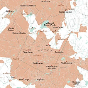
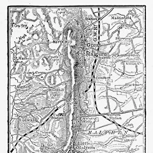
Photographic Print : MA Middlesex Westford Vector Road Map


![]()
Photo Prints from Fine Art Storehouse
MA Middlesex Westford Vector Road Map
MA Middlesex Westford Vector Road Map. All source data is in the public domain. U.S. Census Bureau Census Tiger. Used Layers: areawater, linearwater, roads, rails, cousub, pointlm, uac10
Unleash your creativity and transform your space into a visual masterpiece!
Frank Ramspott
Media ID 20691055
© Frank Ramspott, all rights reserved
City Map Computer Graphic County Digital Composite District Geographical Border Massachusetts Middlesex Road Map Text Vector Carlisle Chelmsford Digitally Generated Image Littleton
10"x10" Photo Print
Discover the unique fusion of art and cartography with our MA Middlesex Westford Vector Road Map print from the Media Storehouse Fine Art Collection. This stunning piece, created by Frank Ramspott, showcases the Middlesex area of Massachusetts in intricate detail. Each line, point, and shape represents source data from the U.S. Census Bureau Census Tiger, skillfully transformed into captivating visual art. Bring historical accuracy and aesthetic appeal to your home or office with this one-of-a-kind, vector-based photographic print.
Photo prints are produced on Kodak professional photo paper resulting in timeless and breath-taking prints which are also ideal for framing. The colors produced are rich and vivid, with accurate blacks and pristine whites, resulting in prints that are truly timeless and magnificent. Whether you're looking to display your prints in your home, office, or gallery, our range of photographic prints are sure to impress. Dimensions refers to the size of the paper in inches.
Our Photo Prints are in a large range of sizes and are printed on Archival Quality Paper for excellent colour reproduction and longevity. They are ideal for framing (our Framed Prints use these) at a reasonable cost. Alternatives include cheaper Poster Prints and higher quality Fine Art Paper, the choice of which is largely dependant on your budget.
Estimated Product Size is 25.4cm x 25.4cm (10" x 10")
These are individually made so all sizes are approximate
Artwork printed orientated as per the preview above, with landscape (horizontal) or portrait (vertical) orientation to match the source image.
FEATURES IN THESE COLLECTIONS
> Fine Art Storehouse
> Map
> Reference Maps
> Animals
> Mammals
> Cats (Wild)
> Tiger
> Animals
> Mammals
> Muridae
> Water Mouse
> Arts
> Contemporary art
> Digital artwork
> Street art
> Arts
> Landscape paintings
> Waterfall and river artworks
> River artworks
> Arts
> Portraits
> Pop art gallery
> Street art portraits
> Arts
> Street art graffiti
> Digital art
> Digital paintings
> Europe
> United Kingdom
> England
> Middlesex
> Related Images
> Maps and Charts
> Related Images
> Popular Themes
> Lake District
EDITORS COMMENTS
This vibrant and detailed print captures the essence of the MA Middlesex Westford Vector Road Map. Created by Frank Ramspott, this digitally generated image showcases a stunning cartography design that is both visually appealing and informative. The map encompasses various layers including areawater, linearwater, roads, rails, cousub, pointlm, and uac10. All source data used in its creation is from the public domain U. S. Census Bureau Census Tiger database. With no people present in the picture, the focus solely lies on the intricate details of this colorful city map. The vector format ensures sharpness and clarity while highlighting geographical borders with precision. From bustling cities to serene lakes and rivers, every element has been meticulously rendered to provide an accurate representation of Middlesex County's towns such as Westford, Graniteville, Chelmsford, Forge Village, Parkerville, Littleton, and Carlisle. This computer graphic composition serves as a valuable tool for navigation or simply appreciating Massachusetts' physical geography. The inclusion of text aids in identifying streets and landmarks throughout the region. Displayed in full color with exceptional attention to detail, this print offers a visually captivating experience for anyone interested in exploring Middlesex County's roadways and natural features. It is a testament to Frank Ramspott's talent as a skilled cartographer who seamlessly blends artistry with functionality.
MADE IN THE USA
Safe Shipping with 30 Day Money Back Guarantee
FREE PERSONALISATION*
We are proud to offer a range of customisation features including Personalised Captions, Color Filters and Picture Zoom Tools
SECURE PAYMENTS
We happily accept a wide range of payment options so you can pay for the things you need in the way that is most convenient for you
* Options may vary by product and licensing agreement. Zoomed Pictures can be adjusted in the Cart.