Metal Print > North America > United States of America > New York > New York > Maps
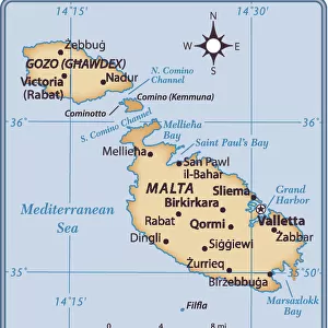
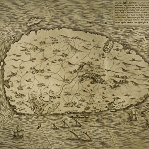
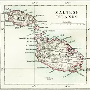
Metal Print : Maltese islands map 1883


![]()
Metal Prints from Fine Art Storehouse
Maltese islands map 1883
Encyclopedia Britannica 9th Edition New York Samuel L. Hall 1883 Vol XV
Unleash your creativity and transform your space into a visual masterpiece!
THEPALMER
Media ID 14713795
© This content is subject to copyright
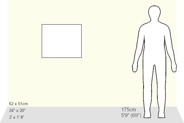
20"x24" (61x51cm) Metal Print
Discover the rich history of the Maltese archipelago with our stunning Metal Print of the 1883 Maltese Islands map from THEPALMER, available at Media Storehouse. This exquisite piece, originally published in the Encyclopedia Britannica 9th Edition, New York, Samuel L. Hall, showcases intricate detail and vintage charm. The high-quality metal print process ensures vibrant colors and a sleek, modern look that adds an elegant touch to any room. Bring a piece of historical cartography into your home and transport yourself to the shores of this beautiful Mediterranean destination.
Made with durable metal and luxurious printing techniques, our metal photo prints go beyond traditional canvases, adding a cool, modern touch to your space. Wall mount on back. Eco-friendly 100% post-consumer recycled ChromaLuxe aluminum surface. The thickness of the print is 0.045". Featuring a Scratch-resistant surface and Rounded corners. Backing hangers are attached to the back of the print and float the print 1/2-inch off the wall when hung, the choice of hanger may vary depending on size and International orders will come with Float Mount hangers only. Finished with a brilliant white high gloss surface for unsurpassed detail and vibrance. Printed using Dye-Sublimation and for best care we recommend a non-ammonia glass cleaner, water, or isopropyl (rubbing) alcohol to prevent harming the print surface. We recommend using a clean, lint-free cloth to wipe off the print. The ultra-hard surface is scratch-resistant, waterproof and weatherproof. Avoid direct sunlight exposure.
Made with durable metal and luxurious printing techniques, metal prints bring images to life and add a modern touch to any space
Estimated Image Size (if not cropped) is 60.9cm x 50.8cm (24" x 20")
Estimated Product Size is 61.5cm x 51.4cm (24.2" x 20.2")
These are individually made so all sizes are approximate
Artwork printed orientated as per the preview above, with landscape (horizontal) orientation to match the source image.
FEATURES IN THESE COLLECTIONS
> Fine Art Storehouse
> Map
> Historical Maps
> Fine Art Storehouse
> Top Sellers - Art Prints
> Fine Art Storehouse
> Travel Imagery
> Travel Destinations
> Malta Through Time
> Europe
> Malta
> Related Images
> Maps and Charts
> Malta
> Maps and Charts
> Related Images
> North America
> United States of America
> New York
> New York
> Maps
> North America
> United States of America
> New York
> Related Images
EDITORS COMMENTS
This print showcases a rare gem from the past, a meticulously detailed map of the Maltese islands dating back to 1883. Taken from the esteemed Encyclopedia Britannica 9th Edition, New York publication by Samuel L. Hall, this vintage piece offers a fascinating glimpse into the historical cartography of Malta and its surrounding regions. The intricate lines and delicate shading on this map beautifully depict Gozo, Malta, Valetta, and other significant locations within these enchanting Mediterranean isles. Every curve and contour tells a story of centuries-old civilizations that have left their mark on this archipelago. Expertly captured by THEPALMER for Fine Art Storehouse, this print transports us back in time to an era when exploration was at its peak. The attention to detail in every inch of this artwork is truly mesmerizing; it invites viewers to immerse themselves in the rich history and cultural heritage of these stunning islands. Whether you are an avid collector or simply appreciate the beauty of antique maps, this exquisite print will undoubtedly become a cherished addition to any space. Let your imagination wander as you trace ancient trade routes or envision yourself strolling through bustling streets frozen in time. Embrace nostalgia with "Maltese Islands Map 1883" - an extraordinary piece that captures both artistry and history within its carefully preserved contours.
MADE IN THE USA
Safe Shipping with 30 Day Money Back Guarantee
FREE PERSONALISATION*
We are proud to offer a range of customisation features including Personalised Captions, Color Filters and Picture Zoom Tools
SECURE PAYMENTS
We happily accept a wide range of payment options so you can pay for the things you need in the way that is most convenient for you
* Options may vary by product and licensing agreement. Zoomed Pictures can be adjusted in the Cart.