Metal Print > Arts > Artists > S > Walter Smalling
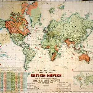
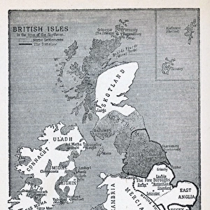
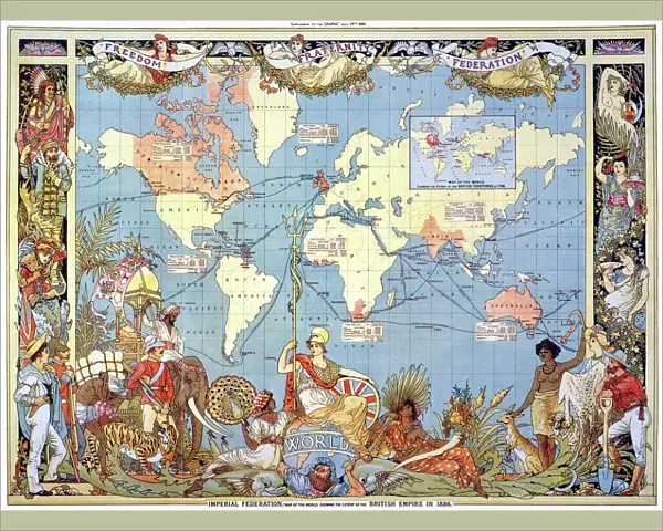
Metal Print : MAP: BRITISH EMPIRE, 1886. Map, 1886, of the British Empire by Walter Crane


Metal Prints from Granger
MAP: BRITISH EMPIRE, 1886. Map, 1886, of the British Empire by Walter Crane
MAP: BRITISH EMPIRE, 1886. Map, 1886, of the British Empire by Walter Crane. The small insert shows, in red, the extent of the British territories in 1786
Granger holds millions of images spanning more than 25,000 years of world history, from before the Stone Age to the dawn of the Space Age
Media ID 6620137
1886 Arts And Crafts Movement British Empire Colonialism Crane Walter World
16"x20" (51x41cm) Metal Print
Step back in time with our stunning Metal Print of the 1886 British Empire Map by Walter Crane, available through Media Storehouse and Granger Art on Demand. This intricately detailed map showcases the vast expanse of the British Empire at the height of its power, with the red insert illustrating the territories held in 1786. Bring history into your home or office with this beautiful and unique piece of art, expertly printed onto high-quality metal for a vibrant, long-lasting display.
Made with durable metal and luxurious printing techniques, our metal photo prints go beyond traditional canvases, adding a cool, modern touch to your space. Wall mount on back. Eco-friendly 100% post-consumer recycled ChromaLuxe aluminum surface. The thickness of the print is 0.045". Featuring a Scratch-resistant surface and Rounded corners. Backing hangers are attached to the back of the print and float the print 1/2-inch off the wall when hung, the choice of hanger may vary depending on size and International orders will come with Float Mount hangers only. Finished with a brilliant white high gloss surface for unsurpassed detail and vibrance. Printed using Dye-Sublimation and for best care we recommend a non-ammonia glass cleaner, water, or isopropyl (rubbing) alcohol to prevent harming the print surface. We recommend using a clean, lint-free cloth to wipe off the print. The ultra-hard surface is scratch-resistant, waterproof and weatherproof. Avoid direct sunlight exposure.
Made with durable metal and luxurious printing techniques, metal prints bring images to life and add a modern touch to any space
Estimated Image Size (if not cropped) is 50.8cm x 37.5cm (20" x 14.8")
Estimated Product Size is 51.4cm x 41.2cm (20.2" x 16.2")
These are individually made so all sizes are approximate
Artwork printed orientated as per the preview above, with landscape (horizontal) orientation to match the source image.
FEATURES IN THESE COLLECTIONS
> Granger Art on Demand
> Maps
> Arts
> Artists
> C
> Walter Crane
> Arts
> Artists
> S
> Walter Smalling
> Maps and Charts
> British Empire Maps
> Maps and Charts
> Popular Maps
> Maps and Charts
> Related Images
> Maps and Charts
> World
EDITORS COMMENTS
This print showcases a historical map of the British Empire in 1886, masterfully created by Walter Crane. The intricate details and vibrant colors bring to life the vast expanse of territories under British rule during this era. As one explores the map, it becomes evident that the empire spanned across continents and oceans, leaving an indelible mark on world history. Walter Crane's artistic prowess is evident in this piece as he skillfully captures not only geographical accuracy but also conveys a sense of grandeur and power associated with colonialism. The inclusion of a small insert highlighting the extent of British territories in 1786 adds depth to our understanding of how much the empire expanded over time. This artwork serves as a poignant reminder of the late colonial period when Britain held significant global influence. It encapsulates an important chapter in world history, shedding light on both the achievements and controversies surrounding imperialism. As part of the Arts and Crafts movement, Walter Crane's work embodies his commitment to combining aesthetics with social commentary. This particular map print stands as a testament to his talent for merging artistry with education. The Granger Collection has once again curated an exceptional piece that invites viewers to delve into history through visual storytelling. Whether displayed at home or in educational settings, this print is sure to spark curiosity and ignite conversations about past empires' legacies.
MADE IN THE USA
Safe Shipping with 30 Day Money Back Guarantee
FREE PERSONALISATION*
We are proud to offer a range of customisation features including Personalised Captions, Color Filters and Picture Zoom Tools
SECURE PAYMENTS
We happily accept a wide range of payment options so you can pay for the things you need in the way that is most convenient for you
* Options may vary by product and licensing agreement. Zoomed Pictures can be adjusted in the Cart.